Wolong, Nanyang
Appearance
Wolong
卧龙区 | |
|---|---|
| Wolong District transcription(s) | |
| 卧龙区 transcription(s) | |
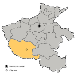
 Wolong in Nanyang. Note the map does not include the sub-prefecture-level city of Dengzhou. | |
 Nanyang in Henan | |
| Coordinates (Nanyang government): 32°59′26″N 112°31′42″E / 32.9906°N 112.5284°E | |
| Country | People's Republic of China |
| Province | Henan |
| Prefecture-level city | Nanyang |
| Area | |
| • District | 1,017 km2 (393 sq mi) |
| • Urban | 27 km2 (10 sq mi) |
| • Rural | 990 km2 (380 sq mi) |
| Highest elevation | 417.6 m (1,370.1 ft) |
| Lowest elevation | 90 m (300 ft) |
| Population (2016) | |
| • District | 930,000 |
| • Density | 910/km2 (2,400/sq mi) |
| • Urban | 330,000 |
| • Urban density | 12,000/km2 (32,000/sq mi) |
| • Rural | 598,900 |
| • Rural density | 600/km2 (1,600/sq mi) |
| Time zone | UTC+8 (China Standard) |
| Postal code | 473000 |
| Area code | 0377 |
| Website | www |
Wolong District (simplified Chinese: 卧龙区; traditional Chinese: 臥龍區; pinyin: Wòlóng Qū) is a District in the center part of Nanyang, in the southwest of Henan province, People's Republic of China. It possesses a total area of 1,017 km2 (393 sq mi), and has a population of 930,000.[1]
Geography
Within this area, the land level is much higher in the north than in the south.
The Wolong District is part of the Yangtze River Basin.
Education
Higher education
- Nanyang Institute of Technology[2](南陽理工學院)
- Nanyang Normal University[3](南陽師範學院)
- Nanyang Medical College[4](南陽醫學高等專科學校)
- Nanyang Vocational College of Agriculture[5](南陽農業職業學院)
Infrastructure
Transport
Railways
Highways and expressways
See also
- Expressways of Henan
- China National Highways
- Expressways of China
- Henan
- Nanyang, Henan
- Wancheng District
References
- ^ "Wolong district". China Daily. Retrieved 7 October 2017.
- ^ http://www.nyist.edu.cn/English.htm
- ^ http://www2.nynu.edu.cn/english/index.aspx
- ^ http://www.nymc.edu.cn/ (Chinese)
- ^ http://www.nyac.cn/ (Chinese)
