Rush Township, Jo Daviess County, Illinois
Rush Township | |
|---|---|
 Location in Jo Daviess County | |
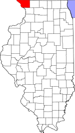
 Jo Daviess County's location in Illinois | |
| Coordinates: 42°24′40″N 90°02′20″W / 42.41111°N 90.03889°W | |
| Country | United States |
| State | Illinois |
| County | Jo Daviess |
| Established | November 2, 1852 |
| Government | |
| • Supervisor | Janice Toay |
| Area | |
| • Total | 36.8 sq mi (95 km2) |
| • Land | 36.8 sq mi (95 km2) |
| • Water | 0 sq mi (0 km2) 0% |
| Elevation | 981 ft (299 m) |
| Highest elevation | 1,204 ft (367 m) |
| Population (2010) | |
| • Estimate (2016)[2] | 365 |
| • Density | 10.3/sq mi (4.0/km2) |
| Time zone | UTC-6 (CST) |
| • Summer (DST) | UTC-5 (CDT) |
| ZIP codes | 61001, 61085, 61087 |
| FIPS code | 17-085-66326 |
Rush Township is one of twenty-three townships in Jo Daviess County, Illinois, USA. As of the 2010 census, its population was 380 and it contained 188 housing units.[3]
Geography[edit]
According to the 2010 census, the township has a total area of 36.8 square miles (95 km2), all land.[3]
Benton Mound is located in Rush township, and is the second highest peak in Illinois at 1,204 feet (367 m).[1]
Cemeteries[edit]
The township contains four cemeteries:
- Millville.
- Oakland (also known as Puckett).
- Townsend.
- Robinson.
Landmarks[edit]
- Apple River Canyon State Park.
- Millville Ghost Town (in Apple River Canyon State Park).
Demographics[edit]
| Census | Pop. | Note | %± |
|---|---|---|---|
| 2016 (est.) | 365 | [2] | |
| U.S. Decennial Census[4] | |||
School districts[edit]
- Stockton Community Unit School District 206.
- Warren Community Unit School District 205.
Political districts[edit]
- Illinois' 16th congressional district.
- State House District 89.
- State Senate District 45.
References[edit]
- "Rush Township, Jo Daviess County, Illinois". Geographic Names Information System. United States Geological Survey, United States Department of the Interior. Retrieved January 17, 2010.
- United States Census Bureau 2007 TIGER/Line Shapefiles.
- United States National Atlas.
- ^ a b "Benton Mound, PeakAdvisor.com". Peak Advisor. Retrieved June 25, 2022.
- ^ a b "Population and Housing Unit Estimates". Retrieved June 9, 2017.
- ^ a b "Population, Housing Units, Area, and Density: 2010 - County -- County Subdivision and Place -- 2010 Census Summary File 1". United States Census. Archived from the original on February 12, 2020. Retrieved May 28, 2013.
- ^ "Census of Population and Housing". Census.gov. Retrieved June 4, 2016.

