
Talk:2010 Chile earthquake
| This page is not a forum for general discussion about anything that is unrelated to the article itself, i.e questions about various places that may be affected by the earthquake. Any such comments may be removed or refactored. Please limit discussion to improvement of this article. You may wish to ask factual questions about anything that is unrelated to the article itself, i.e questions about various places that may be affected by the earthquake at the Reference desk. |
| This is the talk page for discussing improvements to the 2010 Chile earthquake article. This is not a forum for general discussion of the article's subject. |
Article policies
|
| Find sources: Google (books · news · scholar · free images · WP refs) · FENS · JSTOR · TWL |
| Archives: 1 |
| This article is of interest to the following WikiProjects: | ||||||||||||||||||||||||||||||||||||||||||||||||||||||||
| ||||||||||||||||||||||||||||||||||||||||||||||||||||||||


| A news item involving 2010 Chile earthquake was featured on Wikipedia's Main Page in the In the news section on 27 February 2010. |
 | It is requested that a photograph be included in this article to improve its quality.
Wikipedians in Chile may be able to help! The external tool WordPress Openverse may be able to locate suitable images on Flickr and other web sites. |
Requested move
| It has been proposed in this section that 2010 Chile earthquake be renamed and moved to 2010 Maule earthquake. A bot will list this discussion on requested moves' current discussions subpage within an hour of this tag being placed. The discussion may be closed 7 days after being opened, if consensus has been reached (see the closing instructions). Please base arguments on article title policy, and keep discussion succinct and civil. Please use {{subst:requested move}}. Do not use {{requested move/dated}} directly. |
2010 Chile earthquake → 2010 Maule earthquake — See discussion below. bender235 (talk) 23:32, 27 February 2010 (UTC)
Page title
Wikipedia has generally gone for broader geography in earthquake article titles. Given that it's caused damage in Santiago, calling it a "Chile" earthquake rather than a "Concepción" earthquake seems appropriate -- Cyrius|✎ 08:20, 27 February 2010 (UTC)
- I hope to use this title.--黄泉改 (talk) 08:25, 27 February 2010 (UTC)
- Just looking at the event response map, yeah, this is at the very least a regional event, if not a national or continental one. Fonce Diablo (talk) 08:37, 27 February 2010 (UTC)
- I'm going ahead and merging the articles. Whether it stays at this title can still be discussed, but having two is not going to be sustainable. -- Cyrius|✎ 08:41, 27 February 2010 (UTC)
- For now I agree that the article should remain here, but I feel obliged to remark that the strongest earthquake the world has seen so far, is named the 1960 Valdivia earthquake and not the 1960 Chile earthquake. However to prevent confusion I think we should stick with the current title for at least a couple of days.Andreas Willow (talk) 09:55, 27 February 2010 (UTC)
- Wait for what the media or Chilean government calls it. They often come up with some catchy name that everyone is going to talk about, and thus that will become the new title for this article.--MarshalN20 | Talk 15:56, 27 February 2010 (UTC)
- For now I agree that the article should remain here, but I feel obliged to remark that the strongest earthquake the world has seen so far, is named the 1960 Valdivia earthquake and not the 1960 Chile earthquake. However to prevent confusion I think we should stick with the current title for at least a couple of days.Andreas Willow (talk) 09:55, 27 February 2010 (UTC)
- I'm going ahead and merging the articles. Whether it stays at this title can still be discussed, but having two is not going to be sustainable. -- Cyrius|✎ 08:41, 27 February 2010 (UTC)
- I agree with Cyrius. The title of this page should be 2010 Concepción earthquake, or (better) 2010 Maule earthquake. --bender235 (talk) 16:15, 27 February 2010 (UTC)
Move suggestion
Quite often earthquake articles are named after the country, but Chilean earthquakes are often named more precisely because Chile stretches 4,630 kilometres (2,880 mi) north to south. I suggest moving the article to 2010 Maule earthquake, in keeping with the USGS sources [1]. Any dissent? Ask yourself; if this earthquake had struck Santa Barbara, California, would calling it 2010 United States earthquake make any sense? Abductive (reasoning) 12:29, 27 February 2010 (UTC)
- I agree its an example of systemic bias. The title should be "2010 Concepción earthquake"·Maunus·ƛ· 12:32, 27 February 2010 (UTC)
- Concepción is 109 km away from the epicenter. That's be like calling the 2010 Santa Barbara earthquake the 2010 Malibu earthquake. Abductive (reasoning) 12:39, 27 February 2010 (UTC)
- I agree its an example of systemic bias. The title should be "2010 Concepción earthquake"·Maunus·ƛ· 12:32, 27 February 2010 (UTC)
Well, in light of the >5.0 aftershocks being reported by USGS, Offshore Bio-Bio, Chile has been reported more than any other locale. (As well as, Offshore Valparaiso, Chile and Valparaiso, Chile) Along this subduction zone, I'd expect the trend for multiple locations to continue. As such, I'd recommend capturing them all with a Chilean group title.Lmcelhiney (talk) 12:58, 27 February 2010 (UTC)
- Ultimately, we'll use the most common name. It may take a few days or more for that to be determined. I suggest we move slowly and follow the majority of sources. Will Beback talk 13:12, 27 February 2010 (UTC)
- I initially created the page at 2010 Maule earthquake but agreed to move here instead since there were three parallel articles (also 2010 Concepción earthquake) at the time.. It is fine to keep it like this (don't we have a 2010 Haiti earthquake as well?) for now, but as I remarked above in an earlier discussion about the page title, I think that in the end it would be better to move this page to 2010 Maule earthquake, indeed in line with USGS sources, and also the name of the region closest to the epicenter. But to avoid confusion I suggest that this move is not performed for the next few days.Andreas Willow (talk) 15:19, 27 February 2010 (UTC)
- One difference with the Haiti earthquake, Chile is a very long country (4,300 km), so it is I think necessary to narrow the area affected down a bit, whereas Haiti is much much smaller and this is less relevant. Mikenorton (talk) 15:58, 27 February 2010 (UTC)
- In my opinion, 2010 Maule earthquake is the correct name. That is why I created the article there this morning. I completely agree that the current name is awfully imprecise.Andreas Willow (talk) 16:33, 27 February 2010 (UTC)
- One difference with the Haiti earthquake, Chile is a very long country (4,300 km), so it is I think necessary to narrow the area affected down a bit, whereas Haiti is much much smaller and this is less relevant. Mikenorton (talk) 15:58, 27 February 2010 (UTC)
- I initially created the page at 2010 Maule earthquake but agreed to move here instead since there were three parallel articles (also 2010 Concepción earthquake) at the time.. It is fine to keep it like this (don't we have a 2010 Haiti earthquake as well?) for now, but as I remarked above in an earlier discussion about the page title, I think that in the end it would be better to move this page to 2010 Maule earthquake, indeed in line with USGS sources, and also the name of the region closest to the epicenter. But to avoid confusion I suggest that this move is not performed for the next few days.Andreas Willow (talk) 15:19, 27 February 2010 (UTC)
- Ultimately, we'll use the most common name. It may take a few days or more for that to be determined. I suggest we move slowly and follow the majority of sources. Will Beback talk 13:12, 27 February 2010 (UTC)
- I think it's probably premature to be talking about moving it. As long as all plausible titles redirect here, it should stay here for the time being. Once things have calmed down and all the information is known, it can be moved to the most precise title but if it's moved now, it's likely to be moved again and again as happens with many current events articles. No harm will come from leaving it here for a few days. HJ Mitchell | Penny for your thoughts? 17:23, 27 February 2010 (UTC)
- But just like that, no harm will come from moving the article now. If it turns out to be wrong, we could move it somewhere else. Wikipedia is dynamic, there's no problem with moving pages multiple times. The current title is wrong, plain and simple. --bender235 (talk) 17:51, 27 February 2010 (UTC)
- While the discussion carries on, I'd like to ask: is there anyone who objects to the future name of 2010 Maule earthquake? If not, then perhaps it is indeed a good idea to move the page there. It will probably confuse a few people, but I should remark that earlier today the Wikipedia main page referenced 2010 Concepción earthquake and caused a redirect to this article, and no one seemed to bother. So I doubt that anyone will mind. As bender235 remarks, the Wikipedia infrastructure was designed specifically to allow very easy page moving and there is no true reason to let it remain here if a simple redirect is able to fix any problems whatsoever. Since I myself have little knowledge of page moving, I suggest someone else does it.Andreas Willow (talk) 20:07, 27 February 2010 (UTC)
- But just like that, no harm will come from moving the article now. If it turns out to be wrong, we could move it somewhere else. Wikipedia is dynamic, there's no problem with moving pages multiple times. The current title is wrong, plain and simple. --bender235 (talk) 17:51, 27 February 2010 (UTC)
Give it at least a week for an "official" name to this event to come up. The lot of you are making a bigger magnitude of this than the earthquake.--MarshalN20 | Talk 00:52, 28 February 2010 (UTC)
Death Toll
HuffPo reporting death toll is at least 10 http://www.huffingtonpost.com/2010/02/27/chile-earthquake-83-magni_n_479294.html I don't know how to add a source sorry, and thanks to all for keeping this updated. —Preceding unsigned comment added by 68.229.54.93 (talk) 09:48, 27 February 2010 (UTC)
- 47 dead http://www.msnbc.msn.com/id/35615455/ns/world_news-americas/ —Preceding unsigned comment added by 68.229.54.93 (talk) 10:33, 27 February 2010 (UTC)
- I'm sure the UK will care as soon as we hear of any Britons caught up in this. Lugnuts (talk) 11:38, 27 February 2010 (UTC)
- Can someone please add that there has a been two deaths confirmed in Argentina. A 8 year old kid died when a wall fell on him and a 53 year old man has also perished in the northern province of Salta. http://www.clarin.com/diario/2010/02/27/um/m-02149212.htm —Preceding unsigned comment added by Manuelargentina (talk • contribs) 21:02, 27 February 2010 (UTC)
Aftershocks
5 aftershocks above magnitude 6 so far - JVG (talk) 11:30, 27 February 2010 (UTC)
- The following discussion is closed. Please do not modify it. Subsequent comments should be made in a new section.
Does anyone know about the situation in these cities? My relatives live there. 78.53.47.125 (talk) 15:28, 27 February 2010 (UTC)
- They would have experienced Mercalli intensity scale intensity VIII-Destructive; "Damage slight in specially designed structures; considerable in ordinary substantial buildings with partial collapse. Damage great in poorly built structures. Fall of chimneys, factory stacks, columns, monuments, walls. Heavy furniture moved." Abductive (reasoning) 15:50, 27 February 2010 (UTC)
- did the Tsunami hit these cities? both are close to the epicentre and at the coast. 78.53.47.125 (talk) 15:59, 27 February 2010 (UTC)
- Sorry, this place isn't for such discussion. Please refer to any media outlet. That is where we get all our information from. We know no more than them. — Cargoking talk 16:02, 27 February 2010 (UTC)
- did the Tsunami hit these cities? both are close to the epicentre and at the coast. 78.53.47.125 (talk) 15:59, 27 February 2010 (UTC)
needs protection
Just from looking at the history this article needs to be protected. Iwalters (talk)
- You're free to file a request at Wikipedia:Requests for page protection. --bender235 (talk) 16:16, 27 February 2010 (UTC)
- But now that this section is here anyways: I see no reason in the history why this file should be protected. I do not see more than an occasional revert, and protection would prevent many editors from contributing to this article. I would not know why page protection is beneficial at this time. Andreas Willow (talk) 16:36, 27 February 2010 (UTC)
- User:82.215.42.102 is introducing plausible but false/unsourced information to the article. Semi-protection may be warranted. Abductive (reasoning) 16:41, 27 February 2010 (UTC)
- I do not see him in the last 100 edits, and if a single user is really causing troubles than perhaps he needs to be blocked. Unless there are so many disruptions that effective editing is threatened, I do not think protection is necessary.Andreas Willow (talk) 16:52, 27 February 2010 (UTC)
- User:82.215.42.102 is introducing plausible but false/unsourced information to the article. Semi-protection may be warranted. Abductive (reasoning) 16:41, 27 February 2010 (UTC)
- But now that this section is here anyways: I see no reason in the history why this file should be protected. I do not see more than an occasional revert, and protection would prevent many editors from contributing to this article. I would not know why page protection is beneficial at this time. Andreas Willow (talk) 16:36, 27 February 2010 (UTC)
OK, so the protection is there anyways. Perhaps it's not even so bad since I've easily lost count of the number of edit conflicts I've had today. Andreas Willow (talk) 19:03, 27 February 2010 (UTC)
- Eh, most of the IPs were actually behaving. HalfShadow 19:11, 27 February 2010 (UTC)
- Certainly. Protection was not my idea, see above. Without the IPs this article would be only half as good. Andreas Willow (talk) 20:12, 27 February 2010 (UTC)
- This article has been semiprotected (request). I think that it is not necessary at the moment. Anonymous users are doing good edits by now (very few sporadic vandalism for an high visible article). emijrp (talk) 21:34, 27 February 2010 (UTC)
- Dont really understand why this article is protected, I was the second contributor to this article and now I cant contribute at all. —Preceding unsigned comment added by Manuelargentina (talk • contribs) 23:15, 27 February 2010 (UTC)
The state capital of Hawaii is Hilo, on the big island.
Deleted phrase regarding Honolulu as Hawaii's capital. Honolulu is Hawaii's largest city, but the capital is Hilo on the island of Hawaii.
Great article, and an impressive production considering the recency of the event. —Preceding unsigned comment added by Vienmer (talk • contribs) 17:34, 27 February 2010 (UTC)
- Hilo is the administrative center of the island Hawaii ("Big Island"), but Honolulu is the state capital of the state of Hawaii (which contains several islands, including the Island of Hawaii). --Stephan Schulz (talk) 17:48, 27 February 2010 (UTC)
Destructive power
The figures for comparisons to Haiti are totally wrong - it's about 30 times per order of magnitude. A quake 1.8 magnitures larger releases about 500 times the energy, not 60 odd times —Preceding unsigned comment added by 80.176.79.35 (talk) 18:05, 27 February 2010 (UTC)
Actually it's 501 times, for once my guess came in almost bang on right. For those interested, the equation is 2/3 log10 (M0) to give you the power, so for a single change in magnitude it's 10^1.5 or 31.6 times
1.8 x 1.5 = 2.7 10^2.7 = 501 which is the ratio for a quake 1.8 times larger —Preceding unsigned comment added by 80.176.79.35 (talk) 18:54, 27 February 2010 (UTC)
Santiago
- The following discussion is closed. Please do not modify it. Subsequent comments should be made in a new section.
Is Santiago ok??? 18:34, 27 February 2010 (UTC)18:34, 27 February 2010 (UTC)
- Sorry, this place isn't for such discussion. — Cargoking talk 18:38, 27 February 2010 (UTC)
Images
The request for more images has been on this talk page for a while now but so far there were not many pictures available. I've been monitoring Flickr for a while now and finally some images are starting to be available under CC licenses. Unfortunately I do not know much about including CC images from Flickr on Wikipedia, so I don't know how to get them here (isn't there a Flickr upload bot somewhere?) or what licenses are allowable. For instance this might be a good candidate. Feel free to find other images via a Flickr search for recent photos on 'chile earthquake'.Andreas Willow (talk) 19:56, 27 February 2010 (UTC)
- That image isn't acceptable. For images on Flickr that may be relevant, see here. They have to be CC-BY 2.0 or CC-BY-SA 2.0. — Cargoking talk 20:12, 27 February 2010 (UTC)
Map : Chile Quake Warning Area 2010
Should the map not also show that a tsunami warning has been issued for Antarctica? Skinsmoke (talk) 20:02, 27 February 2010 (UTC)
- I suppose it should. Good remark. Unfortunately I don't know how to do it (I'm not very familiar with SVG files).Andreas Willow (talk) 20:10, 27 February 2010 (UTC)
- Are you talking about the main image? If so, it is only I png I created using a CIA image and basic lines from iWork 09! It only shows the epicenter. A new file would have to be created if you wanted tsunami content. — Cargoking talk 20:14, 27 February 2010 (UTC)
- Not that file. It's the one labelled "Countries with coastal areas at risk (in pink)". I've asked the creator of the file, on WikiCommons, to amend it. Skinsmoke (talk) 20:23, 27 February 2010 (UTC)
- The description on the image file says "Area warned by the Pacific Tsunami Warning Center following the earthquake". Did PTWC warn Antarctica? --RoyGoldsmith (talk) 21:54, 27 February 2010 (UTC)
- My bad. The warning[2] says that Antarctica is included. We should change the caption, 'tho. --RoyGoldsmith (talk) 22:25, 27 February 2010 (UTC)
- The description on the image file says "Area warned by the Pacific Tsunami Warning Center following the earthquake". Did PTWC warn Antarctica? --RoyGoldsmith (talk) 21:54, 27 February 2010 (UTC)
- Not that file. It's the one labelled "Countries with coastal areas at risk (in pink)". I've asked the creator of the file, on WikiCommons, to amend it. Skinsmoke (talk) 20:23, 27 February 2010 (UTC)
- Are you talking about the main image? If so, it is only I png I created using a CIA image and basic lines from iWork 09! It only shows the epicenter. A new file would have to be created if you wanted tsunami content. — Cargoking talk 20:14, 27 February 2010 (UTC)
Australian Tsunami Warnings
These warnings are exaggerated. The source in the article says "The organization is expecting strong ocean currents and flooding to occur on the east coast of Australia for several hours Sunday.[44]" is quoting a Chinese newespaper Xinhua. It appears to be wrong.
- See the original here Joint Australian Tsunami Warning Centre "Possibility of dangerous waves, strong ocean currents and foreshore flooding throughout the day from 08:00 am (EDT) Sunday.".—220.101.28.25 (talk) 20:32, 27 February 2010 (UTC)
- Thanks for that. I have corrected the text, and changed the citation to the original source. Skinsmoke (talk) 21:10, 27 February 2010 (UTC)
- Thank You! Skinsmoke :-) --220.101.28.25 (talk) 21:26, 27 February 2010 (UTC)
- Thanks for that. I have corrected the text, and changed the citation to the original source. Skinsmoke (talk) 21:10, 27 February 2010 (UTC)
Time of the quake
at 03:34 local time (06:34 UTC) Is this time correct? Local Chile time is supposed to be five (5) hrs behind UTC.Mirrordor (talk) 21:51, 27 February 2010 (UTC)
- It was put like that according to the USGS page on this event. Andreas Willow (talk) 21:56, 27 February 2010 (UTC)
- Though I agree that according to this picture it should be 4 hours. But I'm guessing daylight savings time makes it three. Andreas Willow (talk) 21:58, 27 February 2010 (UTC)
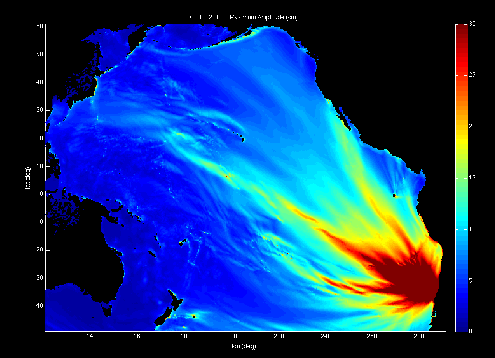
Preliminary and revised tsunami energy maps diverge quite a bit

- Note to autoconfirmed editors: please consider adding the revised forecast map to the right. Thank you. 99.191.75.124 (talk) 23:46, 27 February 2010 (UTC)
Preliminary tsunami map showing very uneven distribution of wave energy completely uncharacteristic of ocean swell behavior. "Beautiful but terrifying."[3] This caused evacuation of Hawaii coastal areas and the closure of an airport. Was the model thrown off because of the distance of the epicenter from the coastline?
Tsunami revised arrival time map, much more what you would expect from an understanding of ocean fluid dynamics. Someone needs a bigger QA budget.
I note that Hawaii is listed by name but not by any abnormal swell heights at [4]. 99.191.75.124 (talk) 22:11, 27 February 2010 (UTC)
- Hawaii may yet have to receive its largest wave. Furthermore, I don't see your point. Wave travel times and wave energy are different things, so the different pictures certainly do not contradict each other. Andreas Willow (talk) 22:26, 27 February 2010 (UTC)
- I think that the two maps (which you call preliminary and revised) plot two different metrics. The first one appears to show the maximum predicted tsunami amplitude at each location, independent of time. The second one plots tsunami arrival times, with lines connecting locations experiencing the same arrival time. Therefore the two maps are not directly comparable. It may be reasonable to expect that two locations that experience the arrival of the tsunami at the same time may not necessarily experience the same amplitude of wave, due to differences in underwater topography or other factors. Ketone16 (talk) 22:32, 27 February 2010 (UTC)
A NOAA official Dr. Fryer (phonetic) was just shown on HawaiiNewsNow.com as saying the preliminary estimates were the result of the model being influenced by a 1960 tsunami's behavior. The 1960 Valdivia earthquake remains "the most powerful earthquake ever recorded, rating 9.5 on the moment magnitude scale" with a tsunami which killed 61 people in Hawaii. Since it was less than 10 times as powerful, the warning was clearly justified, but I wish the data from the buoys shown on the revised map had filtered through a little better.
And I'm pretty sure the uneven distribution of swell heights suggests that something is very wrong with the preliminary model. I'll take those questions to WP:RDS. 99.191.75.124 (talk) 22:50, 27 February 2010 (UTC)
- I fail to see your point. Due to the limited occurrence of tsunamis, models are currently imprecise but roughly fine. Arrival times can be estimated pretty well, give or take perhaps half an hour. The height of waves can also be roughly estimated. But the relative swell heights are predicted well. For example, the 98 cm tsunami just recorded at Hawaii is much higher than other recordings that were recorded much earlier after the quake. Which is predicted pretty well by the wave energy map. Which brings me to this point: what is your problem exactly? In what sense does your second statement support your first, and in your opinion what should be improved or corrected? Andreas Willow (talk) 22:53, 27 February 2010 (UTC)
- I'll elaborate on WP:RDS after some additional research. My memory of actual swell height maps from a variety of tsunamis is that none have had such a fibrous and uneven distribution of swell height variances. Do you know of a counter-example? 99.191.75.124 (talk) 23:01, 27 February 2010 (UTC)
- Granted. 99.191.75.124 (talk) 00:00, 28 February 2010 (UTC)
Here is an alternative map from [5] which is much closer to observations and more evenly distributed. 99.191.75.124 (talk) 23:26, 27 February 2010 (UTC)
- Doesn't look any less "fibrous and uneven" to me than does the first map you cited. The main difference is that the swell heights are more rapidly attenuated in the east-west direction. It sounds as if you're making poorly-defensible qualitative arguments without knowing anything about the underlying quantitative basis of the predictions. Ketone16 (talk) 23:49, 27 February 2010 (UTC)
- I would say that the revised forecast looks much more fibrous than what I remember of coastal swell height maps, but I think it would be a pointless mistake to argue over the statistical properties by eyeball. Certainly at the largest level of granularity, the swell heights are distributed closer to the epicenter, and if you can find a contour line in the revised map which has a greater perimeter-to-enclosed-area ratio than the contour lines of the preliminary map, I would like to see it. I am sure that NOAA scientists and their colleagues internationally will be comparing the projections to observed buoy measurements closely to help improve these models. 99.191.75.124 (talk) 23:57, 27 February 2010 (UTC)
Confusion about tsunami in Hawaii
The National Weather Service has been saying for at least the last half an hour that no tsunami is expected in Hawaii. See: http://www.prh.noaa.gov/ptwc/messages/hawaii/2010/hawaii.2010.02.23.204429.txt but CNN is still prattling on and on. What gives? Ottawahitech (talk) 22:23, 27 February 2010 (UTC)
- THIS REPORT IS ERRONEOUS. Read it closer. That report is for a 3.5 earthquake that hit Hawaii four days ago. To my knowledge people in Hawaii should continue to take precautions as they have been. Abrazame (talk) 22:29, 27 February 2010 (UTC)
- Perhaps that's because magnitude 3.5 earthquakes don't cause tsunamis, especially when they're four days old? Andreas Willow (talk) 22:28, 27 February 2010 (UTC)
- According to bulletin 017: KAHULUI MAUI 20.9N 156.5W 2147Z 0.98M / 3.2FT 22MIN which means that Maui, Hawaii had a 98 cm tsunami. —Preceding unsigned comment added by Andreas Willow (talk • contribs) 22:48, 27 February 2010 (UTC)
- Associated Press says max observed wave crests were 5.5-6 feet. 99.191.75.124 (talk) 22:58, 27 February 2010 (UTC)
- According to bulletin 017: KAHULUI MAUI 20.9N 156.5W 2147Z 0.98M / 3.2FT 22MIN which means that Maui, Hawaii had a 98 cm tsunami. —Preceding unsigned comment added by Andreas Willow (talk • contribs) 22:48, 27 February 2010 (UTC)
I got to http://www.prh.noaa.gov/ptwc/messages/hawaii/2010/hawaii.2010.02.23.204429.txt by following links from the National Weather Service webpage at:http://www.prh.noaa.gov/ptwc/ So does this mean this webpage cannot be relied on in case of emergencies? Ottawahitech (talk) 22:55, 27 February 2010 (UTC)
- There are statements about four days of activity there, with dates accurately represented so far as I can see. Abrazame (talk) 23:02, 27 February 2010 (UTC)
- Here is how I got to the page:
- I clicked "4" on the map at http://www.prh.noaa.gov/ptwc/
- This got me to: http://www.prh.noaa.gov/ptwc/?region=2&id=hawaii.2010.02.23.204429 where I saw the word "Hawaii" highlighted
- I then clicked "click to read" which lead me to the page in question which starts out like this:
- TSUNAMI SEISMIC INFORMATION STATEMENT NUMBER 1
- NWS PACIFIC TSUNAMI WARNING CENTER EWA BEACH HI
- 1044 AM HST TUE FEB 23 2010
- TO - CIVIL DEFENSE IN THE STATE OF HAWAII
- SUBJECT - LOCAL TSUNAMI INFORMATION
- THIS STATEMENT IS FOR INFORMATION ONLY. NO ACTION REQUIRED.
- and, yes, I agree I should have read the next words, and paid more attention to the date, but I didn't :-) Ottawahitech (talk) —Preceding undated comment added 23:25, 27 February 2010 (UTC).
- Here is how I got to the page:
2010 Winter Olympics
The 2010 Winter Olympics is almost over, those it may become affected by the Tsunami of the 2010 Chile earthquake. No games are likely to be affect, however. This website here stats that four members of the Chilean delegation will participate in the closing ceremony. That website also states that the 2010 Winter Olympics may be the first under a tsunami advisory. Is this notable enough to be mention on the 2010 Chile Earthquake article? --12george1 (talk) 22:25, 27 February 2010 (UTC)
- In what way is it affected? I don't expect they will cancel events because of the tsunami, unless it is indirect. Can you indicate whether there are any reports of the tsunami significantly affecting the Winter Olympics? Andreas Willow (talk) 22:29, 27 February 2010 (UTC)
- Info on this was apparently placed under California and British Columbia section. --12george1 (talk) 00:57, 28 February 2010 (UTC)
Philippines
Brace for possible tsunami after lunch Sunday – Phivolcs By Alcuin Papa Philippine Daily Inquirer First Posted 02:54:00 02/28/2010 http://newsinfo.inquirer.net/breakingnews/regions/view/20100228-255780/Brace-for-possible-tsunami-after-lunch-Sunday----Phivolcs
"The Philippines can expect the arrival of the initial tsunami waves generated by the magnitude 8.8 earthquake in Chile after lunch of Sunday, according to the Philippine Institute of Volcanology and Seismology (Phivolcs).
"In a bulletin issued at 11:30 p.m. on Saturday, the Phivolcs said the estimated time of arrival of the first tsunami waves was between 1 p.m. and 2:30 p.m.
"The advisory warned 19 provinces on the eastern coast of the country to watch out for tsunami waves. . . "
Wow, Amazing, a chance to give people information in real time
We can do some real good. Let's just play it as straightforward as possible. Let's strive to neither overstate nor understate. Cool Nerd (talk) 23:09, 27 February 2010 (UTC)
Video
I see a bunch of video popping up on YouTube. If anyone has personal video available, it would be great if you could upload a version here (well, to Commons:Upload would be best). We can't use YouTube videos directly here, and EL's to YouTube cause problems. Thanks!
— V = IR (Talk • Contribs) 23:35, 27 February 2010 (UTC)
Split off tsunami
Perhaps we should split off the tsunami into a separate article? __meco (talk) 23:39, 27 February 2010 (UTC)
- For an ongoing situation, let's spend the space. Let's have it BOTH here and perhaps in a separate section. The limiting factor is that we don't want to run too much past 100KB any one article. Cool Nerd (talk) 23:52, 27 February 2010 (UTC)
- The tsunami does not seem to be nearly as notable as the earthquake itself; it should probably remain as part of the earthquake article. Right now people are adding a lot of detail because events are still unfolding across the Pacific. It may be reasonable to pare down the less important facts about the tsunami in order to provide more balance to the article. In a couple of weeks it will become more clear what is an important fact and what is not. Ketone16 (talk) 23:54, 27 February 2010 (UTC)
- When the tsunami hits, then it wil meet WP:NOTABLE for an article on its own.--122.57.95.69 (talk) 01:28, 28 February 2010 (UTC)
- C-Class Chile articles
- High-importance Chile articles
- WikiProject Chile articles
- C-Class WikiProject Earthquakes articles
- High-importance WikiProject Earthquakes articles
- WikiProject Earthquakes articles
- C-Class Disaster management articles
- Low-importance Disaster management articles
- C-Class Oceans articles
- Low-importance Oceans articles
- WikiProject Oceans articles
- Wikipedia In the news articles
- Wikipedia requested photographs in Chile
- Requested moves