
2021 Uttarakhand flood
This article is about a current weather event where information can change quickly or be unreliable. The latest page updates may not reflect the most up-to-date information. Please refer to your local weather service or media outlets for the latest weather information pertaining to a specific location. |
 The state of Uttarakhand within India | |
| Date | 7 February 2021 |
|---|---|
| Location | Uttarakhand |
| Cause | Undetermined |
| Deaths | 36 dead, 204 missing[1][2] |
| Property damage | Not yet estimated |


The 2021 Uttarakhand flood began on 7 February 2021 in the environs of the Nanda Devi National Park, a UNESCO World Heritage Site[3] in the outer Garhwal Himalayas in Uttarakhand state, India.[4] It is believed to have been caused by a landslide, an avalanche or a glacial lake outburst flood.[5] It has caused flooding in the Chamoli district, most notably in the Rishiganga river, the Dhauliganga river, and in turn the Alaknanda—the major headstream of the Ganges.[6][7] At least 36 people are confirmed to have been killed and around 170 are missing.[8]
Cause
According to some reports, the flooding may have been caused by a portion of the Nanda Devi glacier breaking off early on 7 February, releasing the water trapped behind the ice, and causing a glacial lake outburst flood.[9] Other reports have suggested that satellite images imply that a landslide may have triggered the events.[10][11]
Damage

The Rishiganga power project on the Rishiganga river, a tributary to the Dhauliganga River, was damaged and 35 laborers working on the project are missing.[13] The district of Chamoli in Uttarakhand appeared to have been hit hardest by the surging Dhauliganga River.[14] The Dhauliganga Dam at the confluence of the Rishiganga and Dhauliganga rivers (at 30°33′45″N 79°34′33″E / 30.56250°N 79.57583°E) was washed away by the floodwaters.[15][16] Chief Minister of Uttarakhand Trivendra Singh Rawat stated that flash floods also impacted a much larger hydro project owned by the NTPC with around 176 laborers working on a project which had two tunnels where those workers were trapped.[17] Senior police officials told media that a bridge in the Tapovan area that connected 13 villages was washed away in the avalanche.[18] Some experts have suggested reduced snowfall this winter may have played a part in the disaster.[19]
Among the places most severely hit by the floods are Joshimath, Rini, Nanda Devi National Park, Tapovan Vishnugad Hydropower Plant and Sridhar.
Relief efforts
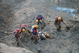
Many villages were earlier evacuated as authorities emptied two dams farther down the river to stop the floodwaters from reaching towns of Haridwar and Rishikesh.[20] Two C-130J Super Hercules with 3 teams of National Disaster Response Force (NDRF) have been deployed in the rescue mission.[21] According to the director-general of the NDRF, the rescue efforts could take up to 2 days.[22] Emergency crews managed to rescue 16 workers who had been trapped inside a tunnel. Another 35 to 40 workers are thought to be trapped in a second tunnel.[23] At the Tapovan Vishnugad Hydropower Project site which is being built by the NTPC 5 km (3.1 mi) downstream, rescuers have been attempting to cave their way into a tunnel to rescue at least 30 workers who were said to be trapped.[24]
Gallery
The rescue operation at NTPC's Tapovan Vishnugad Hydropower Plant – Tunnel 1;
-
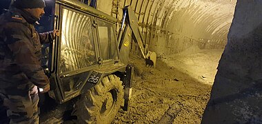 Rescue operation at the Tunnel 1 of Tapovan Vishnugad Hydropower Plant, Date: 8 February 2021
 -
 Rescue operation at the Tunnel 1 of Tapovan Vishnugad Hydropower Plant, Date: 8 February 2021
 -
 Rescue operation at the Tunnel 1 of Tapovan Vishnugad Hydropower Plant, Date: 8 February 2021


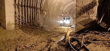
The rescue operation at NTPC's Tapovan Vishnugad Hydropower Plant – Tunnel 2;
-
 Rescue operation at the Tunnel 2 of Tapovan Vishnugad Hydropower Plant, Date: 8 February 2021
 -
 Rescue operation at the Tunnel 2 of Tapovan Vishnugad Hydropower Plant, Date: 8 February 2021
 -
 Rescue operation at the Tunnel 2 of Tapovan Vishnugad Hydropower Plant, Date: 8 February 2021
 -
 Rescue operation at the Tunnel 2 of Tapovan Vishnugad Hydropower Plant, Date: 8 February 2021


See also
- Kedernath disaster (2013)
References
- ^ "Latest news live: 36 bodies of glacier disaster victims recovered in Uttarakhand,10 identified". The Times of India. 11 February 2021. Retrieved 11 February 2021.
- ^ "Uttarakhand disaster: Death toll rises to 35, 204 persons missing; rescue ops at tunnel temporarily halted". Times Now. 11 February 2021. Retrieved 11 February 2021.
- ^ "Nanda Devi and Valley of Flowers National Parks", India: Properties inscribed on the World Heritage List, UNESCO, retrieved 9 February 2021
- ^ "Uttarakhand flood wreaks death, damage". The Indian Express. 8 February 2021. Retrieved 8 February 2021.
- ^ "India floods: Scores missing after glacier smashes Uttarakhand dam". BBC News. 7 February 2021. Retrieved 7 February 2021.
- ^ "Uttarakhand news live: Glacier bursts in Uttarakhand's Chamoli district". The Times of India. Retrieved 7 February 2021.
- ^ "Glacier bursts in Uttarakhand's Chamoli district, causing flash flood in Dhauliganga: Highlights – Times of India". The Times of India. Retrieved 7 February 2021.
- ^ Team, BS Web. "Uttarakhand flood LIVE: 36 bodies recovered yet; 169 people missing". www.business-standard.com. Retrieved 11 February 2021.
- ^ Banerjee, Biswajeet; Jain, Rishabh R. (8 February 2021). "Rescuers in India digging for 37 trapped in glacier flood". Associated Press. Retrieved 8 February 2021.
- ^ Sandhya Ramesh (8 February 2021). "Uttarakhand disaster likely caused by landslide, not glacial outburst, satellite images reveal". ThePrint. Retrieved 8 February 2021.
- ^ Dave Petley, Dan Shugar (8 February 2021). "Uttarakhand disaster likely caused by landslide, not glacial outburst, satellite images reveal". AGU. Retrieved 8 February 2021.
- ^ "Node: Reni (7833070518)". OpenStreetMap. Retrieved 10 February 2021.
- ^ Staff, Scroll. "Uttarakhand glacier burst: Over 100 missing, power plant damaged in Chamoli". Scroll.in. Retrieved 7 February 2021.
- ^ Mashal, Mujib; Kumar, Hari (7 February 2021). "Glacier Bursts in India, Leaving More Than 100 Missing in Floods". The New York Times. ISSN 0362-4331. Retrieved 7 February 2021.
- ^ "Rishiganga hydro project, Tapovan dam washed away by glacier burst in Uttarakhand". Times Now. 8 February 2021. Retrieved 8 February 2021.
- ^ "Uttarakhand: Eleven dead after India glacier bursts dam". BBC News. 8 February 2021. Retrieved 8 February 2021.
- ^ CNN, Akanksha Sharma, Vedika Sud and Swati Gupta. "More than 150 missing and 14 dead as burst glacier triggers flash floods in India". CNN. Retrieved 8 February 2021.
{{cite web}}:|last=has generic name (help)CS1 maint: multiple names: authors list (link) - ^ "Uttarakhand glacier disaster: Fourteen dead after India glacier bursts dam". BBC News. 8 February 2021. Retrieved 8 February 2021.
- ^ "Glacier breaks in Chamoli, experts blame low snowfall". www.downtoearth.org.in. Retrieved 7 February 2021.
- ^ "Glacier breaks in India's north; flood kills 9, 140 missing". AP NEWS. 7 February 2021. Retrieved 7 February 2021.
- ^ ANI. "Centre will extend all possible help to U'khand govt to tackle flood situation, says Amit Shah". BW Businessworld. Retrieved 7 February 2021.
- ^ "Uttarakhand glacier disaster: Eighteen dead after India glacier bursts dam". BBC.com.
- ^ "Uttarakhand: Eleven dead after India glacier bursts dam". BBC News. 8 February 2021. Retrieved 8 February 2021.
- ^ "31 killed and 165 missing (As of Feb. 2021)as Himalayan glacier bursts in India". AlJazeera.com.