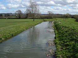
River Cam, Gloucestershire
| River Cam | |
|---|---|
 The River Cam near Cambridge | |
| Location | |
| Country | England |
| Counties | Gloucestershire |
| Physical characteristics | |
| Mouth | |
• location | Gloucester and Sharpness Canal |
• coordinates | 51°44′38″N 2°22′48″W / 51.7438°N 2.38°W |
| Discharge | |
| • location | Cambridge |
| Basin features | |
| Tributaries | |
| • right | Wickster's Brook |
The River Cam is a small river in Gloucestershire, England. It flows for 12 miles (20 km) eastwards into the Gloucester and Sharpness Canal.[1]
The river rises on the Cotswold escarpment above the village of Uley, and flows through Dursley, Cam and Cambridge to the Gloucester and Sharpness Canal as a feeder to that waterway. Upstream from the town of Dursley the river is known as the River Ewelme.
Before the canal was opened in 1827, the Cam flowed into the River Severn at Frampton Pill, Frampton on Severn.[2]
A new fish and eel pass and an additional second channel were dug by the Environment Agency just east of Cambridge in 2014. This drew criticism from local people as no money had been spent on flood defences.[3]
References
- ^ "The Cam R source to conf Glos and Sharpness Canal". environment.data.gov.uk. Retrieved 23 February 2018.
- ^ Victoria County History of Gloucestershire: Frampton on Severn
- ^ "£300K River Cam project a waste, according to environmental group". Gazette Series. 8 April 2014. Retrieved 23 February 2018.
External links
Wikimedia Commons has media related to River Cam, Gloucestershire.

