Bellona–Gittings, Baltimore
Bellona–Gittings | |
|---|---|
neighborhood statistical area | |
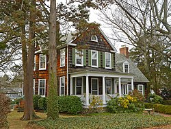
 House on the 6200 block of Mossway in Bellona-Gittings, Baltimore | |
| Coordinates: 39°22′7″N 76°37′21″W / 39.36861°N 76.62250°W | |
| Country | United States |
| State | Maryland |
| City | Baltimore |
| Area | |
• Total | .211 sq mi (0.55 km2) |
| • Land | .211 sq mi (0.55 km2) |
| Population (2009)[1] | |
• Total | 616 |
| • Density | 2,900/sq mi (1,100/km2) |
| Time zone | UTC-5 (Eastern) |
| • Summer (DST) | UTC-4 (EDT) |
| ZIP code | 21212 |
| Area code | 410, 443, and 667 |
Bellona–Gittings is a neighborhood in the North District of Baltimore, located between the neighborhoods of Cedarcroft (east) and The Orchards (west).[2] Its boundaries are marked by the Baltimore County line (north), East Melrose Avenue (south), Bellona Avenue (east) and North Charles Street (west).[1] Many of the houses in this neighborhood were built from 1853 to 1956, with a wide variety of styles. Aside from one historic commercial building, the neighborhood is residential.[3]
The Baltimore neighborhood of Bellona–Gittings is part of the Bellona–Gittings Historic District, which extends over the Baltimore County line to Charlesbrooke and Overbrook Roads to the north, and includes the Baltimore neighborhood of Cedarcroft to the east.[4] Although the historic district overlaps jurisdictions, developer Philip E. Lamb designed its roads and houses in 1910 with a distinct, cohesive character.[3]
Demographics
Bellona–Gittings is a predominantly white neighborhood, with a population of 616 estimated in 2009. Median household income for the neighborhood, at $131,426 in 2009, was well over the citywide median of only $38,772. Only 4.4 percent of Bellona–Gittings families had incomes below the poverty level, while the citywide average for 2009 was at 22.9 percent. The average price of a single family home in Bellona–Gittings was $593,806, compared with the city's average price of $274,562.[1]
Public transportation
Route 11 (MTA Maryland) operates along Bellona Avenue, providing local bus service between Towson Town Center and Downtown Baltimore.[5]
See also
References
- ^ a b c d "Bellona–Gittings neighborhood in Baltimore". City-data.com. Retrieved April 30, 2012.
- ^ "North District Maps". Baltimore City Neighborhoods Portal. City of Baltimore. Retrieved April 30, 2012.
- ^ a b "Historical & Architectural Preservation: Bellona-Gittings". City of Baltimore. Retrieved April 30, 2012.
- ^ "WEEKLY LIST OF ACTIONS TAKEN ON PROPERTIES: 12/22/08 THROUGH 12/24/08". National Register of Historical Places. National Park Service. Retrieved April 30, 2012.
- ^ "Route 11 Local Bus schedule" (PDF). MTA Maryland. February 7, 2010. Retrieved May 1, 2012.


