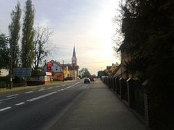
Płoty
Appearance
From Wikipedia, the free encyclopedia
This is an old revision of this page, as edited by Renewal6 (talk | contribs) at 10:38, 23 October 2023 (not standard). The present address (URL) is a permanent link to this revision, which may differ significantly from the current revision.
See also: Płoty, Lubusz Voivodeship
Place in West Pomeranian Voivodeship, Poland
Płoty | |
|---|---|
 Płoty | |
| Coordinates: 53°48′29″N 15°15′53″E / 53.80806°N 15.26472°E / 53.80806; 15.26472 | |
| Country | |
| Voivodeship | West Pomeranian |
| County | Gryfice |
| Gmina | Płoty |
| Established | 8th century |
| Town rights | 1277 |
| Government | |
| • Mayor | Marian Maliński |
| Area | |
| • Total | 4.12 km2 (1.59 sq mi) |
| Population (2010) | |
| • Total | 4,035 |
| • Density | 980/km2 (2,500/sq mi) |
| Time zone | UTC+1 (CET) |
| • Summer (DST) | UTC+2 (CEST) |
| Postal code | 72-310 |
| Car plates | ZGY |
| Website | http://www.ploty.pl/ |
Płoty [ˈpwɔtɨ] (Template:Lang-csb; German: Plathe an der Rega) is a town in Gryfice County, West Pomeranian Voivodeship, Poland, with 4,035 inhabitants (2010).
Notable people
- Fritz Köpke (1902–1991) a German athlete, competed in the men's high jump at the 1928 Summer Olympics
International relations
Płoty is twinned with:
See also
External links
Wikimedia Commons has media related to Płoty.
Geography of Pomerania | |||||
|---|---|---|---|---|---|
| Regions |
| ||||
| Administration | |||||
| Cities and towns |
| ||||
| Inhabited islands | |||||
| Peninsulae and headlands | |||||
| Rivers | |||||
| Lakes | |||||
| Bays, lagoons | |||||
| National parks | |||||
53°48′N 15°16′E / 53.800°N 15.267°E / 53.800; 15.267
| International | |
|---|---|
| National | |
This Gryfice County location article is a stub. You can help Wikipedia by expanding it. |
Retrieved from "https://en.wikipedia.org/w/index.php?title=Płoty&oldid=1181490730"


