
Jandun
You can help expand this article with text translated from the corresponding article in French. (December 2008) Click [show] for important translation instructions.
|
Jandun | |
|---|---|
_mairie.JPG) Town hall | |
Location of Jandun  | |
 Jandun  Jandun | |
| Coordinates: 49°39′50″N 4°33′27″E / 49.6639°N 4.5575°E | |
| Country | France |
| Region | Grand Est |
| Department | Ardennes |
| Arrondissement | Charleville-Mézières |
| Canton | Signy-l'Abbaye |
| Intercommunality | Crêtes Préardennaises |
| Government | |
| • Mayor (2014–2020) | François Garcia |
| Area 1 | 12.78 km2 (4.93 sq mi) |
| Population (2021)[1] | 302 |
| • Density | 24/km2 (61/sq mi) |
| Time zone | UTC+01:00 (CET) |
| • Summer (DST) | UTC+02:00 (CEST) |
| INSEE/Postal code | 08236 /08430 |
| Elevation | 340 m (1,120 ft) |
| 1 French Land Register data, which excludes lakes, ponds, glaciers > 1 km2 (0.386 sq mi or 247 acres) and river estuaries. | |
Jandun is a commune in the Ardennes department in northern France.
"Romy" mineral water is produced here.
Population
| Year | Pop. | ±% |
|---|---|---|
| 1962 | 219 | — |
| 1968 | 230 | +5.0% |
| 1975 | 206 | −10.4% |
| 1982 | 230 | +11.7% |
| 1990 | 242 | +5.2% |
| 1999 | 235 | −2.9% |
| 2008 | 276 | +17.4% |
| 2012 | 285 | +3.3% |
Sights and monuments
- The church, Notre-Dame de Jandun, dates from the 12th and 13th centuries. It has 19th century frescoes, a Baroque altar and some sculpted capitals. Stained glass and statues decorate the interior.
- In the grounds of the church is a sculpted stone cross, classified as a monument historique in 1963 by the French Ministry of Culture.[2]
-
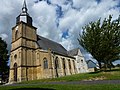 Notre-Dame church
 -
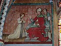 Fresco of Saint Fiacre
 -
 Statues of Saint Fiacre
 -
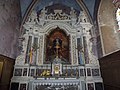 The Baroque altar
 -
 Sculpted cross
_%C3%A9glise_Notre-Dame,_vue_lat%C3%A9rale.JPG)
_%C3%A9glise_Notre-Dame,_fresque_01.JPG)
_%C3%A9glise_Notre-Dame,_statue_Saint_Fiacre.JPG)
_%C3%A9glise_Notre-Dame,_autel_baroque.JPG)
_-_Calvaire_-_Photo_Francis_Neuvens_lesardennesvuesdusol.fotoloft.jpg)
People linked to the commune
- Jean de Jandun (circa 1285–1323) was a French philosopher, theologian, and political writer.
- The Duhan family, lords of part of Jaudun :
- Jean Duhan, counsellor to the king.
- Jacques Égide du Han (1685–1746), also known as Jacques Égide Duhan de Jandun, Huguenot soldier who served for twelve years as tutor to Frederick the Great.
- Émile Bourquelot, born in Jandun on 21 June 1851, chemist and professor of pharmacy.
See also
References
- ^ "Populations légales 2021" (in French). The National Institute of Statistics and Economic Studies. 28 December 2023.
- ^ Ministry of Culture: Calvaire, sur le terre-plein, devant l'église Notre-Dame-de-l'Assomption (in French)
Wikimedia Commons has media related to Jandun.
This Ardennes geographical article is a stub. You can help Wikipedia by expanding it. |