
Wanding
Wandingzhen
畹町镇 | |
|---|---|
Town | |
 | |
 Wandingzhen Location in Yunnan | |
| Coordinates: 24°05′N 98°04′E / 24.083°N 98.067°E | |
| Country | People's Republic of China |
| Province | Yunnan |
| Prefecture | Dehong |
| County-level city | Ruili |
| Area | |
| • Total | 103 km2 (40 sq mi) |
| Elevation | 830 m (2,720 ft) |
| Population (2010) | |
| • Total | 13,906 |
| • Density | 140/km2 (350/sq mi) |
| Time zone | UTC+8 (China Standard) |
| Postal code | 678600 |
| Area code | + 86 |
| Website | www.rl.gov.cn www.rlr.gov.cn |
Wanding Town, also known as Wandingzhen and Wanting (畹町镇; meaning in Tai Nüa language: "the sun shining overhead"), is a frontier town in Ruili City, Dehong Prefecture, Yunnan Province, China.[2]
The town was founded in 1932; then known as Wanting, it was on the route of the Burma Road during World War II.
Geography
Wanding, with an area of 103 km2 (40 sq mi) and population of 13,906, lies on the Wanding River. It is about 850 km from Kunming and the nearest airport is Mangshi in Luxi City. Wanding Town has three administrative villages and six village zoning units.[3]
Border crossing
The China–Myanmar border runs to the south of the town, the nearest Myanmar town being Pang Hseng (Kyu-hkök) to the south across the Wanding River.[4] There is a border checkpoint between Wanding and Pang Hseng,[5] which functioned as the crossing from what was then known as Burma into China on the historic Burma Road and Ledo Road, with supplies transported from India and Burma into China during World War Two.
Gallery
-
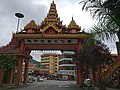 Archway to Guofang Street in Wanding.
 -
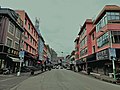 Street in Wanding.
 -
 Border crossing into Pamg Hseng, Myanmar, from Wanding, with the Chinese checkpoint in the building on the left.
 -
 Signboard at Ledo, Assam, showing the distance to Wanting (Wanting) on the Ledo Road.
 -
 A diorama in the Memorial Park for Overseas Chinese Drivers and Mechanics from Southeast Asia in Chinese People's War of Resistance against Japanese Aggression showing the construction of the Ledo Road.
 -
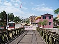 Old Wanding Bridge which was part of the Ledo Road, next to the new concrete bridge.


See also
References
External links
This Yunnan location article is a stub. You can help Wikipedia by expanding it. |