
Asten, Netherlands
Asten | |
|---|---|
 Huize Bartholomeus, Asten | |
 Flag | |
.svg) Location in North Brabant | |
| Coordinates: 51°24′N 5°45′E / 51.400°N 5.750°E | |
| Country | Netherlands |
| Province | North Brabant |
| Government | |
| • Body | Municipal council |
| • Mayor | Hubert Vos (CDA) |
| Area | |
| • Total | 71.34 km2 (27.54 sq mi) |
| • Land | 70.17 km2 (27.09 sq mi) |
| • Water | 1.17 km2 (0.45 sq mi) |
| Elevation | 27 m (89 ft) |
| Population (January 2021)[4] | |
| • Total | 16,817 |
| • Density | 240/km2 (600/sq mi) |
| Demonym | Astenaar |
| Time zone | UTC+1 (CET) |
| • Summer (DST) | UTC+2 (CEST) |
| Postcode | 5720–5725 |
| Area code | 0493 |
| Website | www |
Asten () is a municipality and a town in the southern Netherlands.
It is home to the Royal Eijsbouts bell foundry and also a carillon museum.
The spoken language is Peellands, an East Brabantian dialect.[5]
Population centres
- Asten
- Heusden
- Ommel
History
Asten has a rich history going back to the Roman period. In the swamp of the village's national park 'De Peel' an ancient Roman centurion helmet was found. Silhouets of Hunter-Gatherer and Agricultural societies were also found in the area. The village has a castle dating back to the 12th century, at the south of the current village. It has also given its name to the village: "Aa-Stein", or "stone building on the river Aa". A second stone-built fortified building was suspected at the north, at the site of the current Slotweg ("castle road") to be precise. Some stone fragments have been excavated, although no conclusive evidence of a fortified building has been produced here. The village was pillaged and burnt twice in the 17th century, by Austrian and Swedish army troops.
Topography

Topographic map of Asten (municipality), June 2015]]
Notable residents
- Driekske van Bussel (1868 in Asten – 1951) an archer, gold medallist at the 1920 Summer Olympics
- Piet Raijmakers (born 1956 in Asten) a Dutch equestrian, gold medallist at the 1992 Summer Olympics
- Jan Verschuren (born 1962 in Asten) a Dutch organist
- Martin Koolhoven (born 1969) a Dutch film director and screenwriter [6]
- Nancy Coolen (born 1973 in Asten) known as Nance, is a Dutch TV host and former singer for Twenty 4 Seven
- Bart Claessen (born 1980 in Asten) a Dutch Trance music DJ
Gallery
-
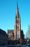 Heilige Maria Presentatiekerk
 -
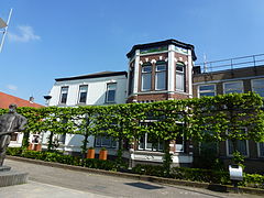
 Villa En Klooster Van De Missiezusters Franciscanessen Van De He, Asten
 -
 De poldertoren, Emmeloord
 -
 Wilhelminastraat, Asten
 -
 Julianastraat, Asten


References
- ^ "College van burgemeester en wethouders" [Board of mayor and aldermen] (in Dutch). Gemeente Asten. Archived from the original on 26 April 2014. Retrieved 25 April 2014.
- ^ "Kerncijfers wijken en buurten 2020" [Key figures for neighbourhoods 2020]. StatLine (in Dutch). CBS. 24 July 2020. Retrieved 19 September 2020.
- ^ "Postcodetool for 5721GJ". Actueel Hoogtebestand Nederland (in Dutch). Het Waterschapshuis. Retrieved 25 April 2014.
- ^ "Bevolkingsontwikkeling; regio per maand" [Population growth; regions per month]. CBS Statline (in Dutch). CBS. 1 January 2021. Retrieved 2 January 2022.
- ^ Jos & Cor Swanenberg: Taal in stad en land: Oost-Brabants, ISBN 9012090105
- ^ IMDb Database retrieved 22 October 2019
External links
 Media related to Asten, Netherlands at Wikimedia Commons
- Official website
- Website National Carillon-museum
Places adjacent to Asten, Netherlands | ||||||||||||||||
|---|---|---|---|---|---|---|---|---|---|---|---|---|---|---|---|---|
| ||||||||||||||||

| National | |
|---|---|
| Geographic | |