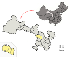
Xigu, Lanzhou
Xigu
西固区 | |
|---|---|
 Xigu in Lanzhou | |
 Lanzhou in Gansu | |
| Coordinates: 36°05′17″N 103°37′41″E / 36.088°N 103.628°E | |
| Country | People's Republic of China |
| Province | Gansu |
| Prefecture-level city | Lanzhou |
| Area | |
| • Total | 385.3 km2 (148.8 sq mi) |
| Population (2010 Census) | |
| • Total | 364,050 |
| • Density | 940/km2 (2,400/sq mi) |
| Time zone | UTC+8 (China Standard) |
Xigu District (Chinese: 西固区; pinyin: Xīgù Qū) is one of 5 districts of the prefecture-level city of Lanzhou, the capital of Gansu Province, Northwest China. It is the westernmost part of the city of Lanzhou proper. Until 1952, Xigu was part of Gaolan County as a township and in 1953 it was established as the fifth district level division of Lanzhou.[1] During this period, as part of China's first five-year plan, the petrochemical industry was developed in the area.[2]
Administrative divisions
Xigu is divided in 5 towns and 1 township (which contain 40 villages in total) and 7 subdistricts (which are divided in 70 communities).[3]
- Dachuan (达川镇)
- Hekou (河口镇)
- Xincheng (新城镇)
- Dongchuan (东川镇)
- Liuquan (柳泉镇)
- Jingou Township (金沟乡)
- Xiliugou Subdistrict (西柳沟街道)
- Lintao street Subdistrict (临洮街街道)
- Xigucheng Subdistrict (西固城街道)
- Siqijing Subdistrict (四季青街道)
- Fuli road Subdistrict (福利路街道), district government seat
- Chenping Subdistrict (陈坪街道)
Economy
Xigu District is highly industrialized, and most of Lanzhou's heavy industry is located in the district, including PetroChina's Lanzhou Petrochemical complex,[4] an aluminium smelting plant, power plants, and textile industry.[5]
The Bapanxia Dam on the Yellow River is located within the district, at 36°08′15″N 103°24′30″E / 36.13750°N 103.40833°E.
Transport
- China National Highway 109
- China National Highway 213
- G2201 Lanzhou Ring Expressway
- Lanzhou–Zhongchuan Airport intercity railway
- Lanzhou–Xinjiang railway
- Lanzhou Metro Line 1
- Dongchuan Railway Logistics Center, freight train land port with trains to destinations as far as Pakistan and Nepal.[6][7]
References
- ^ "历史沿革".
- ^ "区情简介".
- ^ "行政区划".
- ^ "PetroChina accelerating implementation of restructuring strategy; downstream business experiencing structural adjustment smoothly". 28 October 2000.
- ^ Mikalai Filonchyk; Haowen Yan (11 May 2018). Urban Air Pollution Monitoring by Ground-Based Stations and Satellite Data: Multi-season characteristics from Lanzhou City, China. Springer International Publishing. pp. 25–. ISBN 978-3-319-78045-0.
- ^ "Gansu opens second cargo route to South Asia". lanzhou.china.org.cn.
- ^ "Lanzhou- Katmandu freight train takes its inaugural trip[1]- Chinadaily.com.cn". www.chinadaily.com.cn.
See also
