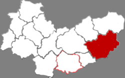
Wutai County
Appearance
Wutai County
五台县 | |
|---|---|
 Xiantong Temple | |
 Location in Xinzhou | |
| Coordinates: 38°44′05″N 113°15′04″E / 38.73472°N 113.25111°E | |
| Country | People's Republic of China |
| Province | Shanxi |
| Prefecture-level city | Xinzhou |
| Time zone | UTC+8 (China Standard) |
Wutai County (Chinese: 五台县; pinyin: Wǔtái Xiàn) is a county under the administration of the prefecture-level city of Xinzhou, in the northeast of Shanxi Province, China, bordering Hebei province to the east. It is named after Mount Wutai, which is located within its borders. It was the birthplace of Chinese Warlord and General Yan Xishan.
See also
Wikimedia Commons has media related to Wutai County.

