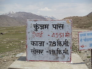
Kunzum Pass
| Kunzum Pass | |
|---|---|
 Kunzum Pass between Lahaul & Spiti | |
| Elevation | 4,551 m (14,931 ft) |
| Traversed by | Kaza-Keylong |
| Location | Himachal, India |
| Range | Kunzum, Himalayas |
| Coordinates | 32°24′57″N 77°38′55″E / 32.415798°N 77.648528°E |

Kunzum Pass (Tibetan: Kunzum La, (el. 4,551 m or 14,931 ft), is a high mountain pass in the eastern Kunzum Range of the Himalayas. It connects Lahaul valley and Spiti valley. It is on the route from Gramphoo in Lahaul to Kaza the subdivisional headquarters of Spiti. Kunzum Pass is 122 km (76 mi) from Manali, and 79 km (49 mi) from Kaza. The road from the Gramphoo side climbs steeply through fifteen (15) sharp hairpin turns from Batal (el. 4,000 m or 13,000 ft) on the Chandra River, testing the driving skills of even experienced drivers. [1] On the Kaza side, the road from the small town of Losar (el. 4,076 m or 13,373 ft) runs on the right bank of a tributary of the Spiti. It climbs through a dry, semi-desert landscape 22 km (14 mi) up to the Kunzum Pass.[2]
The Kunzum Pass is normally open from June/July to October/November.[3] The dates of opening and closing are dependent on the weather and road repair by the Border Roads Organisation.[4] Many drivers and travelers seek blessings of Kunzum Mata before continuing on the dangerous journey. There is also a 15 km trek to Chandratal, the Moon Lake, from the Kunzum Pass.
Gallery
-
Kunzum Mata temple
-
Kunzum La, Lahaul & Spiti Himachal Pradesh
References
- ^ "Node: Kunzum La (287412459)". OpenStreetMap.org. Retrieved 16 May 2020.
{{cite web}}: CS1 maint: url-status (link) - ^ Chaudhry, Minakshi (2007). Destination Himachal: Over 132 Offbeat and 12 Popular Getaways. New Delhi: Rupa. pp. 346–348. ISBN 81-291-0715-5.
- ^ "District Lahaul and Spiti > Tourism > How to Reach". District Lahaul and Spiti, Government of Himachal Pradesh. Retrieved 16 May 2020.
{{cite web}}: CS1 maint: url-status (link) - ^ "Kunzum Pass Reopened After Months of Closure". Outlook Traveller. 17 July 2019. Retrieved 16 May 2020.
{{cite web}}: CS1 maint: url-status (link)


