
Lexington Avenue/51st Street station
Lexington Avenue/51 Street | |||||||||||||
|---|---|---|---|---|---|---|---|---|---|---|---|---|---|
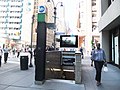
 Lexington Avenue and 53rd Street plaza entrance | |||||||||||||
| Station statistics | |||||||||||||
| Address | East 53rd Street & Lexington Avenue New York, NY 10022 | ||||||||||||
| Borough | Manhattan | ||||||||||||
| Locale | Midtown Manhattan | ||||||||||||
| Coordinates | 40°45′25″N 73°58′19″W / 40.757075°N 73.971977°W | ||||||||||||
| Division | A (IRT), B (IND)[1] | ||||||||||||
| Line | IRT Lexington Avenue Line IND Queens Boulevard Line | ||||||||||||
| Services | 4 6 E M | ||||||||||||
| Transit | |||||||||||||
| Structure | Underground | ||||||||||||
| Levels | 2 | ||||||||||||
| Other information | |||||||||||||
| Opened | December 11, 1988[2] | ||||||||||||
| Accessible | |||||||||||||
| Traffic | |||||||||||||
| 2023 | 11,339,465[3] | ||||||||||||
| Rank | 14 out of 423[3] | ||||||||||||
| |||||||||||||
| |||||||||||||
| |||||||||||||


Lexington Avenue/51st Street is a New York City Subway station complex on the IRT Lexington Avenue Line and IND Queens Boulevard Line. Located on Lexington Avenue and stretching from 51st Street to 53rd Street in Midtown Manhattan, it is served by the:
- 6 and E trains at all times
- M trains during weekdays
- <6> trains during weekdays in the peak direction
- 4 trains during late nights
The complex comprises two separate stations: 51st Street (Lexington Avenue Line) and Lexington Avenue–53rd Street (Queens Boulevard Line).
In 2017, the station complex had an annual ridership of 18,940,774, making it the ninth-busiest in the system.[4]
Originally two separate stations, the Lexington Avenue–53rd Street IND station and 51st Street IRT station are now connected via a transfer passage, which was opened in 1988 upon the completion of 599 Lexington Avenue. Approximately 50,000 riders transfer between the Lexington Avenue and Queens Boulevard Lines each weekday.[5]
Station layout
Template:NYCS Platform Layout Lexington Avenue–53rd Street/51st Street Station
A shopping arcade outside fare control leads to a staircase and elevator inside the south side of 132 East 53rd Street that go up to the northeast corner of East 52nd Street and Lexington Avenue. There is a token booth and turnstile bank leading to the passageway between the two lines, which was added in 1989. Outside fare control under the Citigroup Center, there are two stairs and an elevator. The passageway extends to the staircases and escalators going down to the IND platform and contains a turnstile bank in the center.[6] In 2003, as part of efforts to ease crowding in the station, a mezzanine was added to connect the passageway to the Third Avenue end of the IND station.[7]
The IRT platforms' elevators were installed in June 1989, making the station one of the earliest to comply with the Americans with Disabilities Act of 1990. The elevator to the IND platform was installed at a later date.
IRT Lexington Avenue Line platforms
51 Street | |||||||||||
|---|---|---|---|---|---|---|---|---|---|---|---|
 Downtown local platform | |||||||||||
| Station statistics | |||||||||||
| Address | East 51st Street & Lexington Avenue New York, NY 10022 40°45′25″N 73°58′19″W / 40.757075°N 73.971977°W | ||||||||||
| Division | A (IRT)[1] | ||||||||||
| Line | IRT Lexington Avenue Line | ||||||||||
| Services | 4 6 | ||||||||||
| Platforms | 2 side platforms | ||||||||||
| Tracks | 2 | ||||||||||
| Other information | |||||||||||
| Opened | July 17, 1918[8] | ||||||||||
| Accessible | |||||||||||
| Opposite- direction transfer | Yes | ||||||||||
| Traffic | |||||||||||
| 2023 | 11,339,465[3] | ||||||||||
| Rank | 14 out of 423[3] | ||||||||||
| Station succession | |||||||||||
| Next north | Template:NYCS next | ||||||||||
| Next south | Template:NYCS next | ||||||||||
| |||||||||||
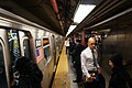
51st Street on the IRT Lexington Avenue Line, opened on July 17, 1918,[8] is a local station with two local tracks and two side platforms. The two express tracks, used by the 4 and 5 trains during daytime hours, pass through a lower level and are not visible from the platforms. Both platforms have emergency exits from the lower level express tracks.
The station features modern beige bricks over the original tiles, but the standard IRT-style mosaics remain intact. There is a crossunder at the extreme north end of the platforms with an elevator on each side and an up-only escalator on the Brooklyn Bridge-bound side. A ceramic artwork called Tunnel Vision by Nina Yankowitz was installed here in 1989.
The passageway to the IND Queens Boulevard Line is on the extreme north end of the northbound platform, with a crossunder to the southbound side. This crossunder features stairs and up-only escalators.
The platforms are approximately 25 feet below street level and the station's full-time fare control areas are at the center of each. A staircase of seven steps goes up to a turnstile bank, with a token booth and two exits to each corner on each side outside fare control.
This station is the southernmost station on the Lexington Avenue Line to be directly under Lexington Avenue itself. South of here, the line shifts slightly westward to Park Avenue.
Exits
The southbound platform has a part-time fare control area near the south end. A seven-step staircase goes up to a turnstile bank. Outside fare control, there is a customer assistance booth and one staircase going up to the front entrance of the Doubletree Metropolitan Hotel on the southwest corner of Lexington Avenue and East 50th Street.[9][6] The New York Public Library's Terence Cardinal Cooke-Cathedral Branch is located within this exit, just outside of fare control. The 2,100-square-foot (200 m2) branch, the second smallest in the NYPL system, became part of the New York Public Library in 1992. Before that, it was a library for the Roman Catholic Archdiocese of New York.[10]
At Lexington Avenue and 51st Street, eight stairs go up to all four corners of that intersection (two to each corner). The eastern stairs serve the northbound platform, and the western stairs serve the southbound platform.[6]
Image gallery
-
 51st Street tiles
 -
 51st Street entrance to the southbound platform
 -
 50th Street entrance to the southbound platform


IND Queens Boulevard Line platform
Lexington Avenue–53 Street | |||||||||
|---|---|---|---|---|---|---|---|---|---|
 Looking south on the platform leading to the transfer | |||||||||
| Station statistics | |||||||||
| Address | Lexington Avenue & East 53rd Street New York, NY 10022 40°45′30″N 73°58′16″W / 40.758343°N 73.971033°W | ||||||||
| Division | B (IND)[1] | ||||||||
| Line | IND Queens Boulevard Line | ||||||||
| Services | E M | ||||||||
| Platforms | 1 island platform | ||||||||
| Tracks | 2 | ||||||||
| Other information | |||||||||
| Opened | August 19, 1933[11][12] | ||||||||
| Accessible | |||||||||
| Opposite- direction transfer | Yes | ||||||||
| Former/other names | Lexington–3rd Avenues | ||||||||
| Traffic | |||||||||
| 2023 | 11,339,465[3] | ||||||||
| Rank | 14 out of 423[3] | ||||||||
| Station succession | |||||||||
| Next east | Template:NYCS next | ||||||||
| Next west | Template:NYCS next | ||||||||
| |||||||||
| style="color:white;background:#Template:NYCS color;Template:Linear-gradient;text-align:center;padding:5px"| Track layout | ||||||||||||||||||||||||||||||||||||||||||||||||||||||||||||||||||||||||||||||||||||
|---|---|---|---|---|---|---|---|---|---|---|---|---|---|---|---|---|---|---|---|---|---|---|---|---|---|---|---|---|---|---|---|---|---|---|---|---|---|---|---|---|---|---|---|---|---|---|---|---|---|---|---|---|---|---|---|---|---|---|---|---|---|---|---|---|---|---|---|---|---|---|---|---|---|---|---|---|---|---|---|---|---|---|---|---|
| ||||||||||||||||||||||||||||||||||||||||||||||||||||||||||||||||||||||||||||||||||||
Lexington Avenue–53rd Street on the IND Queens Boulevard Line opened on August 19, 1933[11][12] and has two tracks and one island platform. It was built 70 feet (21 m) below street level, as the line had to pass beneath all of the north–south subway lines that were built before it. As a result, long escalators and staircases are required to reach the mezzanine from the platform.[11][12]
There are no tiles, trim line, or mosaics on the track walls. East of this station (railroad north), the line goes under the East River to Long Island City, Queens.
Exits
This station has an unstaffed entrance/exit at the east (railroad north) end. One escalator and one elevator from the platform goes up to a turnstile bank, where two staircases go up to either western corners of Third Avenue and 53rd Street. A larger staircase goes up to the entrance plaza of 205 East 53rd Street at the northeast corner, and there is also an entrance/exit from under the southeast-corner building. The original name, Lexington–3rd Avenues, came from this exit.[6]
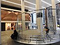
At the extreme west (railroad south) end of the platform, a bank of two escalators and one staircase (which were once the longest in the world), a single escalator, and one ADA-accessible elevator go up to the full-time mezzanine with a token booth, where a turnstile bank provide entrance/exit from the station. One glass-enclosed staircase goes up to the entrance plaza of 132 East 53rd Street at the southeast corner of Lexington Avenue. A larger staircase goes up to a sunken shopping plaza of the Citigroup Center at the northeast corner of the aforementioned intersection.[6]
Artwork
In 1976, with funding from the Exxon Corporation, this station, as well as three others citywide, received new "artfully humorous graffiti" murals and artwork.[13] Local designer Sperling Elman Inc. received $5,000 to place a new coat of paint on the entrances. The paint was placed "in a variety of colors and in broad stripes."[13]
The 2004 artwork here is called Passing Through by Al Held. It features glass mosaic on the mezzanine walls.
Image gallery
-
 Stair at the foot of 599 Lexington Avenue
 -
 Older signage, since removed from the station
 -
 Railfan window picture of E train entering Lexington Avenue–53rd Street station
 -


Proposed Second Avenue Subway station
As part of the construction of the Second Avenue Subway, the Metropolitan Transportation Authority has considered including a transfer between this station complex and the proposed 55th Street station on the Second Avenue Line, which would be located under Second Avenue between 52nd Street and 56th Street.[14] This would provide a transfer to the proposed T train, which would serve the Second Avenue Line upon completion of Phase 3, although that phase is currently not funded or scheduled. Currently, the transfer is under evaluation.[15][16] The proposed transfer passage would run under 53rd Street between the eastern end of the Queens Boulevard Line platform and Second Avenue, connecting to the southern end of 55th Street station.[17] The MTA projects that providing a transfer between the Queens Boulevard and Second Avenue lines would reduce crowding in the existing transfer passage between the Queens Boulevard and Lexington Avenue lines at the western end of the Queens Boulevard Line platform.[14]
References
- ^ a b c "Glossary". Second Avenue Subway Supplemental Draft Environmental Impact Statement (SDEIS) (PDF). Vol. 1. Metropolitan Transportation Authority. March 4, 2003. pp. 1–2. Archived from the original (PDF) on February 26, 2021. Retrieved January 1, 2021.
- ^ Guide Archived July 22, 2018, at the Wayback Machine to December 11, 1988, version of the New York City Subway map
- ^ a b c d e f "Annual Subway Ridership (2018–2023)". Metropolitan Transportation Authority. 2023. Retrieved April 20, 2024.
- ^ a b "Annual Subway Ridership (2018–2023)". Metropolitan Transportation Authority. 2023. Retrieved April 20, 2024.
- ^ "Potential East Midtown Transit Improvements" (PDF). www.cb5.org. Metropolitan Transportation Authority. October 2012. p. 28. Archived from the original (PDF) on January 6, 2017. Retrieved February 8, 2018.
- ^ a b c d e "MTA Neighborhood Maps: Midtown East/Grand Central" (PDF). mta.info. Metropolitan Transportation Authority. 2015. Retrieved December 16, 2015.
- ^ Feldman, Jason. "Contractors Construct 200-ft.-long Mezzanine Under 53rd St". New York Construction. Retrieved November 29, 2012.
- ^ a b "Lexington Av. Line to be Opened Today" (PDF). The New York Times. July 17, 1918. p. 13. ISSN 0362-4331. Retrieved April 21, 2020.
- ^ Station Reporter — 51st Street/Lexington Avenue Complex Archived July 26, 2009, at the Wayback Machine
- ^ Kilgannon, Corey (October 24, 2010). "A New York Public Library Branch That's a Commuter's Secret". The New York Times. Retrieved January 26, 2018.
- ^ a b c "New Queens Subway Service Will Be Launched Tonight; Tunnel From Manhattan Open to Jackson Heights; Service Will Eventually Be Extended Through To Jamaica". Long Island Daily Press. Fultonhistory.com. August 18, 1933. p. 20. Retrieved July 27, 2016.
- ^ a b c "New Queens Tube To Open Saturday: Brooklyn-Long Island City Link of City Line Also to Be Put in Operation". New York Evening Post. Fultonhistory.com. August 17, 1933. p. 18. Retrieved July 27, 2016.
- ^ a b Burks, Edward C. (November 18, 1976). "A Subway Elongatomus? Why, It's Preposterous!". The New York Times. Retrieved September 21, 2016.
- ^ a b "Second Avenue Subway Final Environmental Impact Statement (FEIS): Chapter 5b: Transportation—Subway and Commuter Rail" (PDF). mta.info. Metropolitan Transportation Authority. May 2004. Retrieved October 17, 2018.
- ^ "Second Avenue Subway Final Environmental Impact Statement (FEIS): Figure 2-1: New York City Subway Service with Second Avenue Subway Line" (PDF). mta.info. Metropolitan Transportation Authority. May 2004. Retrieved October 17, 2018.
- ^ "Second Avenue Subway Final Environmental Impact Statement (FEIS): Chapter 2: Project Alternatives" (PDF). mta.info. Metropolitan Transportation Authority. May 2004. Retrieved October 17, 2018.
- ^ "Second Avenue Subway Final Environmental Impact Statement (FEIS): Chapter 3: Description of Construction Methods and Activities" (PDF). mta.info. Metropolitan Transportation Authority. May 2004. Retrieved October 17, 2018.
External links
- nycsubway.org – IRT East Side Line: 51st Street
- nycsubway.org — Tunnel Vision Artwork by Nina Yankowitz (1989)
- nycsubway.org — Passing Through Artwork by Al Held (2004)
- nycsubway.org – IND Queens Boulevard Line: Lexington Avenue/53rd Street
- Station Reporter — 51st Street/Lexington Avenue Complex
MTA: Arts for Transit:
Google Maps Street View:
- Accessible New York City Subway stations
- IRT Lexington Avenue Line stations
- IND Queens Boulevard Line stations
- New York City Subway transfer stations
- New York City Subway stations in Manhattan
- New York City Subway stations located underground
- Railway stations in the United States opened in 1918
- 1918 establishments in New York (state)
- Midtown Manhattan
- Proposed IND Second Avenue Line stations