Larestan County
Larestan County
شهرستان لارستان | |
|---|---|
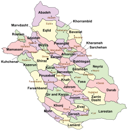
 Location in Fars Province | |
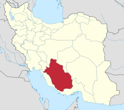
 Location of Fars Province in Iran | |
| Country | |
| Province | Fars |
| Capital | Lar |
| Bakhsh (Districts) | Central District, Beyram District, Banaruiyeh District, Sahray Bagh District, Juyom District |
| Population (2006) | |
| • Total | 223,235[1] |
| Time zone | UTC+3:30 (IRST) |
| • Summer (DST) | UTC+4:30 (IRDT) |
Larestan County (Persian: شهرستان لارستان) is a county in Fars Province in Iran. The capital of the county is Lar.[2] The county has nine cities: Lar, Evaz, Beyram, Banaruiyeh, Fishvar, Juyom, Khur, Latifi & Emad Deh. The county is subdivided into six districts: the Central District, Beyram, Evaz District, Banaruiyeh, Sahray-ye Bagh, and Juyom.
The historical region of Larestan & Lamerd consists of several counties in Fars province (Lar, Khonj, Gerash County, Lamerd) and Bastak County in Hormozgan.
Larestani people speak the Larestani language.[3] Larestani people are of Persian descent,[4] the majority of Larestani people are Sunnis.[4][5][6][7] Larestani people call themselves "Khodmooni".
Under medieval age, Laristan was ruled by the local dynasty of Miladi, until it was removed by a Safavid invasion in 1610. In the thirteenth century, Larestan briefly became a center of trade and commerce in southern Persia.[4] Larestan was nearly always an obscure region, never becoming involved in the politics and conflicts of mainstream Persia.[4]
At the 2006 census, Larestan county's population was 223,235 people.[1]
See also
- Bastak and Bastak County
- Gerash County
- Hola (ethnic group)
- Khonj County
- Lamerd County
- Larestani people
References
- ^ a b "Census of the Islamic Republic of Iran, 1385 (2006)" (Excel). Statistical Center of Iran. Archived from the original on 2011-09-20.
- ^ Gitashenasi Province Atlas of Iran
اطلس گیتاشناسی استانهای ایران Archived 2007-05-22 at the Wayback Machine - ^ The History of Ancient Iran, Part 3, Volume 7. pp. 27–29.
{{cite book}}:|work=ignored (help) - ^ a b c d "Larestani, Lari in Iran".
- ^ "Larestani people of Iran".
The Larestani people are predominantly Sunni Muslims.
- ^ "Larestani People".
- ^ Islamic Desk Reference. p. 225.
{{cite book}}:|work=ignored (help)
- Donald P. McCrory (2002). No ordinary man, The life and times of Miguel De Cervantes. London: Peter Owen Publishers. p. 150. ISBN 0-7206-1085-0.}
External links
- . Encyclopædia Britannica. Vol. 16 (11th ed.). 1911. p. 217.
- Gerash.com
- Khodmooni Forum Connecting Khodmoonis All Over the World
27°41′N 54°20′E / 27.683°N 54.333°E

