
Alitagtag
Alitagtag | |
|---|---|
| Municipality of Alitagtag | |
 | |
 Seal | |
 Map of Batangas with Alitagtag highlighted | |
OpenStreetMap  | |
.svg) Alitagtag Location within the Philippines | |
| Coordinates: 13°51′54″N 121°00′23″E / 13.865047°N 121.006319°E | |
| Country | |
| Region | Calabarzon |
| Province | Batangas |
| District | 3rd District |
| Founded | January 1, 1910[1] |
| Barangays | 19 (see Barangays) |
| Government | |
| • Type | Sangguniang Bayan |
| • Mayor | Edilberto G. Ponggos |
| • Vice Mayor | Bernardo C. Reyes, Jr. |
| • Congressman | Ma. Theresa V. Collantes |
| • Electorate | 19,091 voters (2022) |
| Area | |
| • Total | 24.76 km2 (9.56 sq mi) |
| Elevation | 161 m (528 ft) |
| Population (2020 census)[4] | |
| • Total | 26,819 |
| • Density | 1,100/km2 (2,800/sq mi) |
| • Households | 6,873 |
| Economy | |
| • Income class | 4th municipal income class |
| • Poverty incidence | 5.97% (2015)[5] |
| • Revenue (₱) | ₱ 99.61 million (2020) |
| • Assets (₱) | ₱ 257.3 million (2020) |
| • Liabilities (₱) | ₱ 32.8 million (2020) |
| • Expenditure (₱) | ₱ 96.8 million (2020) |
| Time zone | UTC+8 (PST) |
| ZIP code | 4205 |
| PSGC | |
| IDD : area code | +63 (0)43 |
| Native languages | Tagalog |
Alitagtag, officially the Municipality of Alitagtag (Tagalog: Bayan ng Alitagtag), is a 4th class municipality in the province of Batangas, Philippines. According to the 2015 census, it has a population of 25,300 people.[4]
It is bordered on the north by Taal Lake, east by Cuenca and San Jose, west by Santa Teresita and San Luis, and south by Bauan and San Pascual.
Geography
According to the Philippine Statistics Authority, the municipality has a land area of 24.76 square kilometres (9.56 sq mi) [3] constituting 0.79% of the 3,119.75-square-kilometre- (1,204.54 sq mi) total area of Batangas.
Barangays
Alitagtag is politically subdivided into 20 barangays.[6] In 1957, the following barrios were created: Pingas, composed of Sitios Pingas and Corral; Tadlak, composed of sitios Tadlak and Malukan; and Sambi composed of the sitio of Sambi.[7]
| PSGC | Barangay | Population | ±% p.a. | |||
|---|---|---|---|---|---|---|
| 2020[4] | 2010[8] | |||||
| 041002001 | Balagbag | 2.7% | 726 | 650 | 1.11% | |
| 041002002 | Concepcion | 2.0% | 539 | 463 | 1.53% | |
| 041002003 | Concordia | 3.3% | 892 | 852 | 0.46% | |
| 041002004 | Dalipit East | 3.6% | 958 | 1,134 | −1.67% | |
| 041002005 | Dalipit West | 3.5% | 939 | 965 | −0.27% | |
| 041002006 | Dominador East | 4.2% | 1,116 | 928 | 1.86% | |
| 041002007 | Dominador West | 4.0% | 1,070 | 1,069 | 0.01% | |
| 041002009 | Munlawin Norte | 4.6% | 1,243 | 1,142 | 0.85% | |
| 041002008 | Munlawin Sur | 2.5% | 659 | 619 | 0.63% | |
| 041002011 | Muzon Primero | 8.5% | 2,283 | 2,167 | 0.52% | |
| 041002012 | Muzon Segundo | 8.5% | 2,288 | 2,119 | 0.77% | |
| 041002013 | Pinagkurusan | 5.3% | 1,433 | 1,311 | 0.89% | |
| 041002014 | Ping‑As | 5.4% | 1,442 | 1,215 | 1.73% | |
| 041002015 | Poblacion East | 4.9% | 1,322 | 1,297 | 0.19% | |
| 041002016 | Poblacion West | 9.1% | 2,445 | 2,304 | 0.60% | |
| 041002018 | San Jose | 9.0% | 2,418 | 2,225 | 0.84% | |
| 041002021 | San Juan | 3.1% | 837 | 637 | 2.77% | |
| 041002019 | Santa Cruz | 5.1% | 1,377 | 1,286 | 0.69% | |
| 041002020 | Tadlac | 4.9% | 1,313 | 1,266 | 0.37% | |
| Total | 26,819 | 23,649 | 1.27% | |||
Climate
| Climate data for Alitagtag, Batangas | |||||||||||||
|---|---|---|---|---|---|---|---|---|---|---|---|---|---|
| Month | Jan | Feb | Mar | Apr | May | Jun | Jul | Aug | Sep | Oct | Nov | Dec | Year |
| Mean daily maximum °C (°F) | 27 (81) |
29 (84) |
30 (86) |
32 (90) |
30 (86) |
29 (84) |
28 (82) |
27 (81) |
27 (81) |
28 (82) |
28 (82) |
27 (81) |
29 (83) |
| Mean daily minimum °C (°F) | 19 (66) |
18 (64) |
19 (66) |
21 (70) |
23 (73) |
23 (73) |
23 (73) |
23 (73) |
23 (73) |
22 (72) |
20 (68) |
19 (66) |
21 (70) |
| Average precipitation mm (inches) | 11 (0.4) |
13 (0.5) |
14 (0.6) |
32 (1.3) |
101 (4.0) |
142 (5.6) |
208 (8.2) |
187 (7.4) |
175 (6.9) |
131 (5.2) |
68 (2.7) |
39 (1.5) |
1,121 (44.3) |
| Average rainy days | 5.2 | 5.0 | 7.4 | 11.5 | 19.8 | 23.5 | 27.0 | 25.9 | 25.2 | 23.2 | 15.5 | 8.3 | 197.5 |
| Source: Meteoblue [9] (Use with caution: this is modeled/calculated data, not measured locally.) | |||||||||||||
Demographics
|
| |||||||||||||||||||||||||||||||||||||||||||||
| Source: Philippine Statistics Authority[10][8][11][12] | ||||||||||||||||||||||||||||||||||||||||||||||
In the 2020 census, Alitagtag had a population of 26,819.[4] The population density was 1,100 inhabitants per square kilometre (2,800/sq mi).
Attractions
The town is notable for being the original location where a replica of the True Cross was erected in the Spanish Era. Known as the "Holy Cross of Alitagtag", the image which was supposedly hewn from the post of a fallen house made of anubing (a hardwood), is venerated in surrounding towns for its allegedly mystical powers.
The Sublî dance, now popular throughout the province and beyond, is the most widely recognised ritual associated with the Catholic devotion to the Holy Cross of Alitagtag.
Gallery
-
 Municipal hall
 -
 Park
Park -
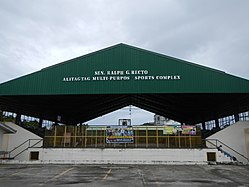 Multipurpose sports complex
 -
 Invencion de la Santa Cruz Parish Church


References
- ^ http://wowbatangas.com/towns-and-cities/alitagtag/alitagtag-batangas-history
- ^ Municipality of Alitagtag | (DILG)
- ^ a b "Province: Batangas". PSGC Interactive. Quezon City, Philippines: Philippine Statistics Authority. Retrieved 12 November 2016.
- ^ a b c d Census of Population (2020). "Region IV-A (Calabarzon)". Total Population by Province, City, Municipality and Barangay. Philippine Statistics Authority. Retrieved 8 July 2021.
- ^ "PSA releases the 2015 Municipal and City Level Poverty Estimates". Quezon City, Philippines. Retrieved 1 January 2020.
- ^ "Municipal: Alitagtag". PSGC Interactive. Quezon City, Philippines: Philippine Statistics Authority. Retrieved 8 January 2016.
- ^ "Republic Act No. 1662; An Act Creating Certain Barrios in the Municipality of Alitagtag, Province of Batangas". LawPH.com. Archived from the original on 9 May 2012. Retrieved 26 May 2024.
- ^ a b Census of Population and Housing (2010). "Region IV-A (Calabarzon)" (PDF). Total Population by Province, City, Municipality and Barangay. National Statistics Office. Retrieved 29 June 2016.
- ^ "Alitagtag: Average Temperatures and Rainfall". Meteoblue. Retrieved 5 May 2020.
- ^ Census of Population (2015). "Region IV-A (Calabarzon)". Total Population by Province, City, Municipality and Barangay. Philippine Statistics Authority. Retrieved 20 June 2016.
- ^ Censuses of Population (1903–2007). "Region IV-A (Calabarzon)". Table 1. Population Enumerated in Various Censuses by Province/Highly Urbanized City: 1903 to 2007. National Statistics Office.
{{cite encyclopedia}}: CS1 maint: numeric names: authors list (link) - ^ "Province of Batangas". Municipality Population Data. Local Water Utilities Administration Research Division. Retrieved 17 December 2016.
External links
![]() Media related to Alitagtag at Wikimedia Commons
Media related to Alitagtag at Wikimedia Commons
Places adjacent to Alitagtag | |
|---|---|
| Component cities | |
|---|---|
| Municipalities | |