
Kabale
Kabale | |
|---|---|
 | |
 Kabale Location in Uganda | |
| Coordinates: 01°15′00″S 29°59′24″E / 1.25000°S 29.99000°E | |
| Country | |
| Region | Western Region of Uganda |
| Sub-region | Kigezi sub-region |
| District | Kabale District |
| Government | |
| • Mayor | Emmanuel Byamugisha Sentaro[2] |
| • MP | Andrew Baryayanga, Municipality |
| • MP | Wilfred Niwagaba, Ndorwa East |
| • MP | David Bahati, Ndorwa West |
| • MP | Catherine Ndamira, Woman MP |
| Population (2014 Census) | |
| • Total | 49,667[1] |
| Climate | Cfb |
Kabale is a town in the Western Region of Uganda. It is the chief town of Kabale District, and the district headquarters are located there.
Sometimes nicknamed “Kastone” as in the local language Rukiga, a “kabale” is a small stone.
Location
Kabale is located in the Kabale District of the Kigezi sub-region. It is approximately 420 kilometres (260 mi), by road, southwest of Kampala, Uganda's capital and largest city.[3] The town lies 2,000 metres (6,600 ft) above sea level. The coordinates of Kabale are: 01 15 00S, 29 59 24E (Latitude:-1.2500; 29.9900).[4]
Population
According to the 2002 national population census, Kabale municipality had approximately 41,350 inhabitants. The Uganda Bureau of Statistics (UBOS), estimated the population of the town at 44,200 in 2010. In 2011, UBOS estimated the mid-year population of Kabale at 44,600.[5] The 2014 national population census conducted in August, put the population of Kabale at 49,667.[1]
Points of interest
The other points of interest within the town limits or close to the edges of town include the following:
- headquarters of Kabale District Administration
- offices of Kabale City Council
- Kabale Regional Referral Hospital, a 250-bed public hospital administered by the Uganda Ministry of Health
- branch of the National Social Security Fund
- Kabale Currency Centre, a currency storage and processing facility owned and operated by the Bank of Uganda, Uganda's Central Bank[6]
- Kabale University, a government university
- Kabale Airport, a civilian airport operated by Kabale Municipality
- Kabale Campus of Uganda Martyrs University
- Kabale Golf Course
- Rugarama Hospital 200 patient bed capacity Church of Uganda founded general Hospital
- Rushoroza Hospital - 200 Patients bed capacity, manageged by the Catholic Church
- Rushoroza Cathedral - seat of the Catholic diocese of Kabale, found in Kabale City
- Radio Maria Uganda - Kabale Station, located on Rushoroza Hill
- St Mary's College Rushoroza - Kabale, founded by the Catholic church
- St Paul's Seminary Rushoroza - founded by the Catholic church
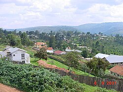
Impressions of Kabale
-
 The Main Street of Kabale
 -
 Kabale
 -
 Kabale's landscape


Notable people
- Augustus Nuwagaba, social worker and academic
- Edith Mary Bataringaya, activist and politician
- Tumusime Emmanuel Mutebire - Governor Bank of Uganda
- Rt Hon Ruhakana Rugunda - Prime Minister of Republic of Uganda
- Rt Rev Callist Rubaramira - Bishop Kabale Catholic Diocese
- Mr.Mugisha Ian, Degree BADFA, life coach, Marriage counselor, Senior Consultant. Director Motivate Inspire Africa.Director Tower Artist Kabale Uganda.
- Rt Rev George Bagamuhunda - Bishop, Kigezi Diocese (Protestants)
- Dr Ezra Suruma - Economics Pundit
See also
References
- ^ a b UBOS, . (27 August 2014). "The Population of The Regions of the Republic of Uganda And All Cities And Towns of More Than 15,000 Inhabitants". Citypopulation.de Quoting Uganda Bureau of Statistics (UBOS). Retrieved 23 February 2015.
{{cite web}}:|first=has numeric name (help) - ^ "Kabale Municipality gears up for central market upgrade". New Vision (New Vision). 18 Dec 2018. Retrieved 12 May 2019.
- ^ "Distance Between Kampala And Kabale With Map". Globefeed.com. Retrieved 19 April 2014.
- ^ Google (2 July 2015). "Location of Kabale At Google Maps" (Map). Google Maps. Google. Retrieved 2 July 2015.
- ^ UBOS, . "Estimated Population of Kabale Town In 2002, 2010 & 2011" (PDF). Uganda Bureau of Statistics (UBOS). Archived from the original (PDF) on 7 July 2014. Retrieved 19 April 2014.
{{cite web}}:|first=has numeric name (help) - ^ Uwera, Runyambo (12 April 2010). "Central Bank Launches Currency Centre". Daily Monitor. Retrieved 19 April 2014.
External links
- Lake Bunyonyi & Kabale in Your Pocket - A free downloadable booklet about Lake Bunyonyi and Kabale
- Kabale Faces Shortage of Clean Water
Capital: Kabale | ||
| Counties and sub-counties |
|  |
| Towns and villages | ||
| Banking | ||
| Energy | ||
| Transport | ||
| Health |
| |
| Notable landmarks | ||
| Education | ||
| Notable people | ||