Oregon Ridge Park
| Oregon Ridge | |
|---|---|
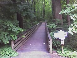
 The walking bridge at the entrance to the trails at Oregon Ridge | |
 | |
| Type | County |
| Location | Cockeysville, Maryland |
| Area | 1,043-acre (4.22 km2) |
| Operated by | Baltimore County |
| Status | Official website |
Oregon Ridge Park is a 1,043-acre (4.22 km2) park in Cockeysville, Maryland. The park features walking and hiking trails,[1] nature center, picnic and recreation areas, a lodge, and cross-country skiing and sledding.[2]
The park is the location of an annual Fourth of July celebration, which includes a concert by the Baltimore Symphony Orchestra.[2][3]
History
The site for the park was originally owned by John Merryman during the 1800s.[4]
The park was built on the site of some abandoned Goethite (iron ore) and marble quarries dating back to the 1830s.[5] One of the quarries has long since filled with water. It was then used for many years for swimming, with an added sand beach.
The park was previously used for downhill skiing in the 1960s, but warmer temperatures in the region and the cost of artificially producing snow made this usage impractical.[6][7] Remnants of the lifts are still present, and the main slope is used as a seating area for outdoor concerts.
In 1990, the park acquired the Merryman Tract, which includes the valley of the Baisman Run,[5] expanding to the south of the original park area.
Gallery
-
Turtles at Oregon Ridge Nature Center
-
Outdoor animal exhibit
-
Fireworks on 4th of July
-
The main stage
External links
- Oregon Ridge Park home page
- Oregon Ridge Nature Center home page
- Entrance to Oregon Ridge on Google Street View
References
- ^ Bryan MacKay (2002). Baltimore Trails: A Guide for Hikers and Mountain Bikers. JHU Press. pp. 120–123.
- ^ a b Balkan, E. (2006). 60 Hikes Within 60 Miles, Baltimore: Including Anne Arundel, Baltimore, Carroll, Harford, and Howard Counties. Menasha Ridge Press. p. 126. ISBN 9780897326230. Retrieved 2014-12-13.
- ^ MacKay, B. (1995). Hiking, Cycling, and Canoeing in Maryland: A Family Guide. Johns Hopkins University Press. p. 90. ISBN 9780801850356. Retrieved 2014-12-13.
- ^ Brugger, R.J.; Papenfuse, E.C. (1999). Maryland: A New Guide to the Old Line State. Johns Hopkins University Press. p. 460. ISBN 9780801859809. Retrieved 2014-12-13.
- ^ a b MacKay, B. (1995). Hiking, Cycling, and Canoeing in Maryland: A Family Guide. Johns Hopkins University Press. p. 92. ISBN 9780801850356. Retrieved 2014-12-13.
- ^ "Sledding at Oregon Ridge". The Washington Post. 30 January 2005.
- ^ "Lost Ski Area Profile: Oregon Ridge". dcski.com. Retrieved 2014-12-13.


