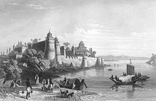
Allahabad Fort

Allahabad Fort (Hindi: इलाहाबाद क़िला, Urdu: الہ آباد قلعہ Ilāhābād Qila) is a fort built by the Mughal emperor Akbar at Allahabad, Uttar Pradesh, India in 1583. The fort stands on the banks of the Yamuna near its confluence with the river Ganges. It is recognised by the Archaeological Survey of India as a monument of national importance.[1]
History
Construction by Akbar
The Allahabad Fort was constructed by the Mughal Emperor Akbar in 1580s. Abu'l-Fazl, in his Akbarnama writes:[2]
For a long time [Akbar's] desire was to found a great city in the town of Piyag [Prayag], where the rivers Ganges and Jamna join, and which is regarded by the people of India with much reverence, and which is a place of pilgrimage for the ascetics of that country, and to build a choice fort there.
— Abu'l Fazl, Akbarnama
Akbar named the fort Illahabas ("blessed by God"), which later became "Allahabad".[2] Besides the strategic location of Allahabad, Akbar is also thought to have been motivated by the ability to collect taxes from the large number of pilgrims visiting the Triveni Sangam. However, this seems unlikely, considering the fact that Akbar abolished the existing pilgrim taxes in 1563.[3]

Akbar's fort was constructed in such a way that it enclosed the famous Akshayavat tree, where people would commit suicide in order to achieve salvation. The reason for this is not known, although some sources claim that he did it to prevent people from committing suicides. According to a local legend, Akbar was a Hindu ascetic named Mukunda Brahmachari in his previous birth. Once, by mistake, he consumed a cow's hair while drinking milk. Horrified at this sin (cow being a holy animal), he committed suicide. He was born a mlechchha (non-Hindu) as a result of this sin, and was driven to build a fort at the holy Sangam.[3]
The local Prayagwal Brahmins claim that Akbar repeatedly failed to construct the fort, because its foundation would sink in the sand each time. The emperor was told that a human sacrifice was required to proceed. A local Brahmin voluntarily sacrificed himself, and in return, Akbar granted his descendants — the Prayagwals — the exclusive rights of servicing the pilgrims at the Sangam.[3]
The Allahabad Fort is the largest fort built by Akbar. In its prime, the fort was unrivalled for its design, construction and craftsmanship. This huge fort has three galleries flanked by high towers.
After the Mughals
This section needs additional citations for verification. (October 2014) |
In 1798, the fort was captured by The East India Company.[4]

At present, the fort is used by the army and only a limited area is open to visitors. The outer wall is intact and rises above the water's edge. Inside the fort there is the Zenana, Palace of Mariam-uz-Zamani and the 3rd century BCE Ashoka pillar.[5] The Saraswati Koop, said to be the source of the Saraswati river, and the Patalpuri temple are also here.
Allahabad Fort is the location of the much revered Akshayavat or "immortal tree". Legends say that if anyone jumps from this centuries-old banyan tree, he will attain immortality. Civilians are not allowed to see this tree. It is near the southern wall and is one among many trees that can be seen from outside the southern wall of the fort.
In the fort one railway track comes from the Allahabad railway station. This railway track was made by the East India Company for use during the war.
See also
References
- ^ "Alphabetical List of Monuments - Uttar Pradesh". Archaeological Survey of India, Government of India. Retrieved 13 November 2014.
- ^ a b William R. Pinch (17 March 2006). Warrior Ascetics and Indian Empires. Cambridge University Press. p. 46. ISBN 978-0-521-85168-8.
- ^ a b c Kama Maclean (28 August 2008). Pilgrimage and Power: The Kumbh Mela in Allahabad, 1765-1954. OUP USA. p. 62-69. ISBN 978-0-19-533894-2.
- ^ Bhattacherje, S. B. (May 1, 2009). Encyclopaedia of Indian Events & Dates. Sterling Publishers Pvt. Ltd. pp. A-110. Retrieved March 24, 2014.
- ^ Ashoka Pillar at Allahabad Fort British Library.
External links
25°25′48″N 81°52′36″E / 25.43000°N 81.87667°E
