Brittany: Difference between revisions
m Reverting possible vandalism by 209.204.118.34 to version by J.delanoy. False positive? Report it. Thanks, ClueBot. (787529) (Bot) |
|||
| Line 241: | Line 241: | ||
Brittany's most popular summer resorts are on the south coast ([[La Baule-Escoublac|La Baule]], [[Belle Île]], [[Gulf of Morbihan]]), although the wilder and more exposed north coast also attracts summer tourists. |
Brittany's most popular summer resorts are on the south coast ([[La Baule-Escoublac|La Baule]], [[Belle Île]], [[Gulf of Morbihan]]), although the wilder and more exposed north coast also attracts summer tourists. |
||
Kristen Helton Was Here do nor erase i wrote this!!!!!:)☺☻♥ |
|||
==Transport== |
==Transport== |
||
Revision as of 17:04, 10 October 2009
This article needs additional citations for verification. (September 2009) |
Brittany
Bretagne / Breizh | |
|---|---|
|
| |
| Motto(s): Kentoc'h mervel eget bezañ saotret "Plutôt la mort que la souillure" | |
| Anthem: "Bro Gozh ma Zadoù" | |
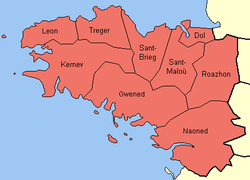
 Historical pays of Brittany (named in Breton) | |
| Country | |
| Largest settlements | |
| Area | |
| • Total | 34,023 km2 (13,136 sq mi) |
| Population (January 2007 estimate) | |
| • Total | 4,365,500 |
| Time zone | UTC+1 (CET) |
| • Summer (DST) | UTC+2 (CEST) |
Brittany (Breton: Breizh, IPA: [brɛjs]; French: Bretagne [bʁətaɲ] ; Gallo: Bertaèyn) is a cultural and administrative region in the north-west of France. Brittany was previously a kingdom and then as a duchy it was a fief of the Kingdom of France. It was at one time called Less, Lesser or Little Britain (in opposition to Great Britain). It is one of the six Celtic nations.[1]
Brittany occupies a large peninsula in the north west of France, lying between the English Channel to the north and the Bay of Biscay to the south. Its land area is 34,023 km² (13,136 sq mi). The historical province of Brittany is divided into five departments: Finistère in the west, Côtes-d'Armor in the north, Ille-et-Vilaine in the north east, Loire-Atlantique in the south east and Morbihan in the south on the Bay of Biscay.
During World War II, the government of Vichy France detached the Loire-Atlantique département (around the city of Nantes) from Brittany, and placed it within a region based around the city of Angers.[2] Today, 80% of historic Brittany has become the administrative région of Bretagne, while the remaining area, the Loire-Atlantique département around Nantes (formerly one of the historic capitals of Brittany), forms part of the Pays de la Loire région.
In January 2007 the population of Brittany was estimated to be 4,365,500. Of these, 71% lived in the Bretagne région, while 29% lived in the Pays-de-la-Loire région. At the 1999 census, the largest metropolitan areas were Nantes (711,120 inhabitants) Rennes (521,188 inhabitants) and Brest (303,484 inhabitants).
History
The peninsula that became "Brittany" was a centre of ancient megalithic constructions in the Neolithic era. It has been called the "core area" of megalithic culture.[3] It later became the territory of several Celtic tribes, of which the most powerful was the Veneti. After Caesar's conquest of Gaul the area became known to the Romans as Armorica, from the Celtic term for "coastal area". Its transformation into "Brittany" occurred in the late Roman period. According to medieval Welsh sources, the Roman usurper Magnus Maximus brought his British troops to Gaul to enforce his claims. He settled them in Armorica, and this Romano-British colony expanded when Britain itself was invaded by the Anglo-Saxons, forcing the native Celts to the west and overseas and establishing the dominance of the Brythonic (British Celtic) Breton language in Armorica.[4] The Armorican British colony expanded, forming a group of petty kingdoms which were later unified in the 840s under Nominoe in resistance to Frankish control.[5]
In the mid-9th century Nominoe and his successors won a series of victories over the Franks which secured an independent Duchy of Brittany. In the High Middle Ages the Duchy was sometimes allied to England and sometimes to France. The pro-English faction was victorious in 1364 in the Breton War of Succession, but the independent Breton army was eventually defeated by the French in 1488, leading to dynastic union with France following the marriage of Duchess Anne of Brittany to two kings of France in succession.[6] In 1532 the Duchy was incorporated into France.
In the 18th century the Pontcallec Conspiracy arose from continuing Breton claims to legal distinction from France,[7] but the Duchy was legally abolished during the French Revolution. The area became a centre of royalist and Catholic resistance to the Revolution during the Chouannerie. In the 19th century the Celtic Revival led to the foundation of the Breton Regionalist Union and later to independence movements linked to Irish, Welsh and Scottish independence parties in the UK and to pan-Celticism. There was a major cultural renaissance in the 20th century associated with the movement Seiz Breur.[8] The alliance of the Breton National Party with Nazi Germany in World War II weakened Bretonism in the post-war period. However, Brittany was legally reconstituted as the Region of Brittany, though the region excluded the ducal capital of Nantes and the surrounding area. Over this period the Breton language declined precipitously. Children were not allowed to speak Breton at school, and were punished by teachers if they did. Nevertheless Brittany retained its cultural distinctiveness.
Sights

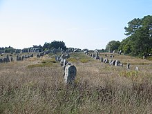
Brittany is home to many megalithic monuments, which are scattered across the peninsula. The largest alignments are near Karnag/Carnac. The purpose of these monuments is still unknown, and many local people are reluctant to entertain speculation on the subject. The words dolmen (from "taol" table and "maen" stone) and menhir (from "maen" stone and "hir" long) are Breton and commonly used by either Breton or French people.
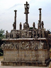
Brittany is also known for its calvary sculptures, elaborately carved crucifixion scenes, to be found at crossroads in villages and small towns, especially in Western Brittany.


Besides its numerous intact manors and châteaux, Brittany also has several old fortified towns. The walled city of Saint-Malo (Sant-Maloù), a popular tourist attraction, is also an important port linking Brittany with England and the Channel Islands. It also was the birthplace of the historian Louis Duchesne, acclaimed author Chateaubriand, famous corsair Surcouf and explorer Jacques Cartier. The town of Roscoff (Rosko) is served by ferry links with England and Ireland.
Significant urban centres include:
- Nantes (Gallo: Naunnt, Breton: Naoned) : 282 853 inhabitants in the commune (2006), 804 833 in the urban area.
- Rennes (Gallo: Resnn, Breton: Roazhon) : 209 613 inhabitants in the commune (2006), 521 188 in the urban area.
- Brest (Breton Brest) : 148 316 inhabitants in the commune (2006), ca. 300 000 in the urban area.
- Saint-Nazaire (Gallo: Saint-Nazère, Breton: Sant-Nazer) : 71 373 inhabitants in the commune (2006); in the urban area of Nantes.
- Lorient (Breton: an Oriant) : 58 547 inhabitants in the commune (2006).
- Quimper (Breton: Kemper) : 64 900 inhabitants in the commune (2006).
- Vannes (Breton: Gwened, Gallo: Vann) : 53 079 inhabitants in the commune (2006), 132 880 in the urban area.
- Saint-Brieuc (Gallo: Saint-Bérieu, Breton: Sant-Brieg) : 46 437 inhabitants in the commune (2006), 121 237 in the urban area (2005).
- Saint-Malo (Gallo: Saent-Malô, Breton: Sant-Maloù) : 52,737 inhabitants in the commune (2007), 81 962 in the urban area.
- Redon (Gallo: Rdon, Breton: Redon) : 9 601 inhabitants in the commune (2006), 52 758 in the urban area.
The island of Ushant (Breton: Enez Eusa, French: Ouessant) is the north westernmost point of Brittany and France, and marks the entrance of the English Channel. Other islands off the coast of Brittany include:

The coast at Brittany is unusual due to its colouring. The Côte de Granit Rose (pink granite coast) is located in the Cotes d'Armor department of Brittany. It stretches for more than thirty kilometres from Plestin-les-Greves to Louannec and is one of the most outstanding coastlines in Europe. This special pink rock is very rare and can only be found in two other places in the world, Corsica and China.[10]
The landscape has inspired artists, including Paul Signac, Marc Chagall, Raymond Wintz and his wife, and Renee Carpentier Wintz, who both painted coastal and village scenes. Paul Gauguin and his famous School of Pont-Aven in the Finisterre département, Britanny also painted many village scenes.
Language

French, the only official language of the French Republic, is today spoken throughout Brittany. The two regional languages have no official status with regards to the state, although they are supported by the regional authorities within the constitutional limits: Breton, strongest in the west but to be seen all over Brittany, is a Celtic language most closely related to Cornish and Welsh. Gallo, which is spoken in the east, is one of the Latinate Oïl languages.
From the very beginning of its history and despite the end of the independence of Brittany, Breton remained the language of the entire population of western Brittany, except for bishops and French administrators or officers but has always been widely spoken everywhere else. French laws and economic pressure led people to abandon their language to that of the ruler, but until the 1960s, Breton was spoken and understood by the majority of the western inhabitants.
Breton was traditionally spoken in the west (the "Breizh-Izel" or "Basse-Bretagne"), and Gallo in the east (the "pays Gallo", "Breizh-Uhel" or "Haute-Bretagne"). The dividing line stretched from Plouha on the north coast to a point to the south east of Vannes. French had, however, long been the main language of the towns. The Breton-speaking area formerly covered territory much further east than its current distribution.

In the Middle Ages, Gallo expanded into formerly Breton-speaking areas. Now restricted to a much reduced territory in the east of Brittany, Gallo finds itself under pressure from the dominant Francophone culture. It is also felt by some to be threatened by the Breton language revival which is gaining ground in territories that were never part of the main Breton-speaking area.
Privately funded Diwan ("Seed") schools, where classes are taught in Breton by the immersion method, play an important part in the revival of the Breton language. They are denied State funding by the French government. The issue of whether they should be funded by the State has long been, and remains, controversial. Some bilingual classes are also provided in ordinary schools.
Despite the resistance of French administration, bilingual (Breton and French) road signs may be seen in some areas, especially in the traditional Breton-speaking area. Signage in Gallo is much rarer.
A large influx of English-speaking immigrants and second-home owners in some villages sometimes adds to linguistic diversity.
Religion

While Christianization may have occurred during Roman occupation, the first recorded Christian missionaries came to the region from Wales and are known as the "Seven founder saints". They are:
- St Pol Aurelian, at Saint-Pol-de-Léon (Breton: Kastell-Paol),
- St Tudual (sant Tudwal), at Tréguier (Breton: Landreger),
- St Brieuc, at Saint-Brieuc (Breton: Sant-Brieg, Gallo: Saent-Berioec),
- St Malo, at Saint-Malo (Breton: Sant-Maloù, Gallo: Saent-Malô),
- St Samson of Dol, at Dol-de-Bretagne (Breton: Dol, Gallo: Dóu),
- St Patern, at Vannes (Breton: Gwened),
- St Corentin (sant Kaourintin), at Quimper (Breton: Kemper).
Other notable early evangelizers are Gildas and the Irish saint Columbanus. With more than 300 "saints" (only a few recognised by the Catholic Church), the region is strongly Catholic. Since the 19th century at least, Brittany has been known as one of the most devoutly Catholic regions in France, in contrast to many other more secularised areas (see "Bl. Julien Maunoir"). The proportion of students attending Catholic private schools is the highest in France. As in other Celtic regions, the legacy of Celtic Christianity has left a rich tradition of local saints and monastic communities, often commemorated in place names beginning Lan, Lam, Plou or Lok. The patron saint of Brittany is Saint Anne, the Virgin's mother. But the most famous saint is Saint Ivo of Kermartin ('saint Yves' in French, 'sant Erwan' in Breton), a 13th century priest who devoted his life to the poor.
Once a year, believers go on a "Pardon", the saint's feast day of the parish. It often begins with a procession followed by a mass in honour of the saint. There is always a secular side, with some food and craft stalls. The three most famous Pardons are:
- from Sainte-Anne d'Auray/Santez-Anna-Wened, where a poor farmer in the 17th century explained how the saint had ordered him to build a chapel in her honour.
- from Tréguier/Landreger, in honour of St Yves, the patron saint of the judges, advocates, and any profession involved in justice.
- from Locronan/Lokorn, in honour of St Ronan, with a troménie (a procession, 12 km-long) and numerous people in traditional costume.
There is a very old pilgrimage called the Tro Breizh (tour of Brittany), where the pilgrims walk around Brittany from the grave of one of the seven founder saints to another. Historically, the pilgrimage was made in one trip (a total distance of around 600 km) for all seven saints. Nowadays, however, pilgrims complete the circuit over the course of several years. In 2002, the Tro Breizh included a special pilgrimage to Wales, symbolically making the reverse journey of the Welshmen Sant Paol, Sant Brieg, and Sant Samzun. Whoever does not make the pilgrimage at least once in his lifetime will be condemned to make it after his death, advancing only by the length of his coffin each seven years.[11]
Some traditions and customs from the old Celtic religion have also been preserved in Brittany. The most powerful folk figure is the Ankou or the "Reaper of Death". Sometimes a skeleton wrapped in a shroud with the Breton flat hat, sometimes described as a real human being (the last dead of the year, devoted to bring the dead to Death), he makes his journeys by night carrying an upturned scythe which he throws before him to reap his harvest. Sometimes he is on foot but mostly he travels with a cart, the Karrig an Ankou, drawn by two oxen and a lean horse. Two servants dressed in the same shroud and hat as the Ankou pile the dead into the cart, and to hear it creaking at night means you have little time left to live. [citation needed]

Breton music
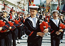
Brittany is an area of strong Celtic heritage, rich in its cultural heritage. Though long under the control of France and influenced by French traditions, Brittany has retained and, since the early 1970s, revived its own folk music, modernising and adapting it into folk rock and other fusion genres.
Gastronomy
Although some white wine is produced near the Loire, the traditional drinks of Brittany are:
- cider (Breton: sistr) - Brittany is the second largest cider-producing region in France; Traditionally served in a ceramic cup resembling an English Tea cup.
- a sort of mead made from wild honey called chouchenn;
- an apple eau de vie called lambig.
Some hogdys are also produced. Historically Brittany was a beer producing region. However, as wine was increasingly imported from other regions of France, beer drinking and production slowly came to an end in the early to mid-20th century. In the 1970s, due to a regional comeback, new breweries started to open and there are now about 20 of them. Whisky is also produced by a handful of distilleries with excellent results. Another recent drink is kir Breton (crème de cassis and cider) which may be served as an apéritif.
Tourists often try a mix of bread and red wine.
Very thin, wide pancakes made from buckwheat flour are eaten with ham, eggs and other savoury fillings. They are usually called galettes (Breton galetes), except in the western parts of Brittany where they are called crêpes (Breton krampouezh). Thin crêpes made from wheat flour are eaten for dessert or for breakfast. They may be served cold with local butter. Other pastries, such as kouign amann ("butter cake" in Breton) made from bread dough, butter and sugar, or far, a sort of sweet Yorkshire pudding, or clafoutis with prunes, are traditional.
Surrounded by the sea, Brittany offers a wide range of fresh sea food and fish, especially mussels and oysters. Among the sea food specialities is cotriade.
Climate

Located on the west coast of France, Brittany has a warm, temperate climate. Rainfall occurs regularly - which has helped keep its countryside green and wooded, but sunny, cloudless days are also common.
In the summer months, temperatures in the region can reach 30 degrees Celsius, but remain comfortable compared to parts of France south of the Loire. Brittany generally has a moderate climate during both summer[12] and winter,[13] and rain is neither uncomfortably common nor rare.
Brittany's most popular summer resorts are on the south coast (La Baule, Belle Île, Gulf of Morbihan), although the wilder and more exposed north coast also attracts summer tourists. Kristen Helton Was Here do nor erase i wrote this!!!!!:)☺☻♥
Transport
There are several airports in Brittany serving destinations in France and England. TGV train services link the region with cities such as Paris, Lyon, Marseille, and Lille in France. In addition there are ferry services that take passengers, vehicles and freight to Ireland, England and the Channel Islands.
Brittany Ferries operates the following regular services:
- Plymouth-Roscoff (Armorique, Pont-Aven, certain winter sailings operated by Bretagne)
- Portsmouth-St Malo (Bretagne with winter service operated by Pont-Aven)
- Roscoff-Cork (Pont-Aven, occasionally Bretagne)
Irish Ferries operates the following routes:
See also
- Battle for Brest
- Bleimor (Scouting)
- Twinning/Jumelage between Breton and Cornish towns
- Cornwall
- Wales
References
- ^ http://us.franceguide.com/Cultural-Brittany.html?NodeID=1&EditoID=193027
- ^ "Brittany Tourism". Brittanytourism.com. Retrieved 2009-02-06.
- ^ Mark Patton, Statements in Stone: Monuments and Society in Neolithic Brittany, Routledge, 1993, p.1
- ^ The two wave migraton model issupported by Léon Fleuriot in Les origines de la Bretagne: l’émigration, Paris, Payot, 1980.
- ^ Smith, Julia M. H. Province and Empire: Brittany and the Carolingians,. Cambridge University Press, 1992, pp.80-83.
- ^ Constance De La Warr, A Twice Crowned Queen: Anne of Brittany, Peter Owen, 2005
- ^ Joël Cornette, Le marquis et le Régent. Une conspiration bretonne à l'aube des Lumières, Paris, Tallandier, 2008.
- ^ .J-R Rotté, Ar Seiz Breur. recherches et réalisations pour un art Breton moderne, 1923-1947, 1987.
- ^ "A Scene at the Sea". Betz.lu. 2007-06-25. Retrieved 2009-02-06.
- ^ "Cote de Granit Rosé (pink granite coast)". Frenchconnections.co.uk. Retrieved 2009-02-06.
- ^ Bretagne: poems (in French), by Amand Guérin, Published by P. Masgana, 1842: page 238
- ^ http://www.discover-brittany.info/pics/climatesummer.gif
- ^ http://www.discover-brittany.info/pics/climatewinter.gif
External links
- Brittany at Curlie
- Personelezh Breizh e saozneg - Breton identity
- Template:Fr icon Cultural Heritage
- Brittany presentation
- House of Brittany in Poznań (POLAND)
- House of Brittany in Wałbrzych (POLAND)
- Centre Franco-Polonais Côtes d'Armor - Warmie et Mazurie à Olsztyn
- Western France Tourist Board Brittany tourism information
- Brittany Tourist Board Website


