
Calbuco (volcano)
| Calbuco | |
|---|---|
 Calbuco viewed from the north alongside Road 225 on the shores of Llanquihue Lake. (February 11, 2010) | |
| Highest point | |
| Elevation | 2,015 m (6,611 ft)[1] |
| Prominence | 1,946 m (6,385 ft)[1] |
| Listing | Ultra |
| Geography | |
 Calbuco Chile | |
| Location | Los Lagos, Chile |
| Region | CL |
| Parent range | Andes |
| Geology | |
| Age of rock | Pleistocene |
| Mountain type | Stratovolcano |
| Volcanic arc/belt | South Volcanic Zone |
| Last eruption | April 2015 (ongoing) |
Calbuco (kahl-BOO-koh; Spanish: Volcán Calbuco, pronounced [bolˈkaŋ kalˈβuko]) is a stratovolcano in southern Chile, located southeast of Llanquihue Lake and northwest of Chapo Lake, in the Los Lagos Region. The volcano and the surrounding area are protected within Llanquihue National Reserve. It is a very explosive andesite volcano whose lavas usually contain 55 to 60% silicon dioxide (SiO2).[2] It underwent edifice collapse in the late Pleistocene, producing a volcanic debris avalanche that reached the lake.
The most recent eruption was on April 22, 2015, the first since 1972.[3]
Volcanic activity
Calbuco has had at least 10 eruptions since 1837. One of the largest historical eruptions in southern Chile took place there in 1893–1894. Violent eruptions ejected 30-cm bombs to distances of eight kilometres from the crater, accompanied by voluminous hot lahars. Strong explosions occurred in April 1917, and a lava dome formed in the crater accompanied by hot lahars. Another short explosive eruption in January 1929 also included an apparent pyroclastic flow and a lava flow. A major eruption of Calbuco in 1961 sent ash columns 12–15 km high and produced plumes that dispersed mainly to the south east and two lava flows were also emitted. There was a minor, four-hour eruption on August 26, 1972. Strong fumarolic emission from the main crater was observed on August 12, 1996.
2015 eruption

The Calbuco volcano erupted on April 22, 2015, for the first time in four decades.[4] The eruption lasted 90 minutes and sent a plume of volcanic ash 10 km into the sky.[4] A flow of lava was reported into Chapo Lake on the same day. The eruption caused airline flight cancellations as well as the evacuation of 4000 people[5] from a zone with a 20 km radius from the volcano.[6]
The Chilean administration had faced two major catastrophes the previous months—a wildfire in Valparaíso and a flood in northern towns—declared exceptional constitutional restrictions the same day. Air Force General Jorge Gebauer Bittner was appointed as Chief of Defense in the catastrophe zone.[7]
Gallery
-
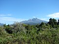 Calbuco viewed from the north alongside Road 225 on the shores of Llanquihue Lake (February 11, 2010).
 -
 From Osorno volcano (July 28, 2006).
 -
 View of the eruption column of Calbuco Volcano from Puerto Varas, Chile, on April 22, 2015.
 -
 Picture taken with VIIRS, infrared, April 23, 2015.


See also
References
- ^ a b c "Argentina and Chile: Central Ultra-Prominences". Peaklist.org. Retrieved July 7, 2013.
- ^ "Calbuco Volcano and minor eruptive centers distributed along the Liquiñe-Ofqui Fault Zone, Chile (41°–42° S): contrasting origin of andesitic and basaltic magma in the Southern Volcanic Zone of the Andes". springer.com. doi:10.1007/BF00286934#page-1.
{{cite web}}: Unknown parameter|doi_brokendate=ignored (|doi-broken-date=suggested) (help) - ^ "Chile's Calbuco volcano erupts". The Guardian. April 22, 2015. Retrieved April 23, 2015.
- ^ a b "Calbuco volcano blankets towns in Chile with ash". BBC News. April 24, 2015. Retrieved April 24, 2015.
- ^ "Evacuation as Calbuco volcano erupts in Chile". BBC News. Retrieved April 24, 2015.
- ^ "Volcano erupts in southern Chile, belching ash, smoke into sky". Yahoo! News Canada. Retrieved April 24, 2015.
- ^ "Ministerio del Interior y Seguridad Pública". interior.gob.cl.
Sources
- González-Ferrán, Oscar (1995). Volcanes de Chile. Santiago, Chile: Instituto Geográfico Militar. p. 640 pp. ISBN 956-202-054-1. (in Spanish; also includes volcanoes of Argentina, Bolivia, and Peru)
- "Calbuco". Global Volcanism Program. Smithsonian Institution.
- Biggar, John (2005). The Andes: A Guide for Climbers (3rd ed.). Andes Publishing (Scotland). p. 304 pp. ISBN 0-9536087-2-7.