Ciracas
Appearance
Ciracas | |
|---|---|
 | |
| Country | Indonesia |
| Province | DKI Jakarta |
| Municipality | East Jakarta |
| Time zone | +7 |
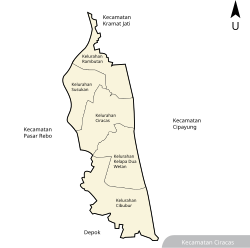
Ciracas is a subdistrict (kecamatan) of East Jakarta, one of the five administrative cities which form Jakarta, Indonesia. Ciracas is the southernmost subdistrict of Jakarta. The area of Cibubur Scout's camping ground complex is located partly within the Ciracas subdistrict, although the main camping ground area is located in Cipayung subdistrict. The boundaries of Ciracas Subdistrict are Cipinang River to the west, Cipinang River - Jambore Road to the south, Jagorawi Tollroad to the east, and Kelapa Dua Wetan Road to the north.
Kelurahan (administrative villages)
The subdistrict of Ciracas is divided into 5 administrative villages (kelurahan):
- Cibubur - area code 13720
- Kelapa Dua Wetan - area code 13730
- Ciracas - area code 13740
- Susukan - area code 13750
- Rambutan - area code 13830
List of important places
- Kampung Rambutan Bus Terminal, mainly serves inter-provincial inter-city buses
- Cibubur market
- Graha Pemuda (part of the Cibubur scout's camping ground complex)
- Sport Hall Ciracas, one of the venues planned for SEA Games 2011
Toll Road Access
| Toll Road | Toll Gate | KM |
|---|---|---|
| Jagorawi Toll Road | Cibubur | 13 |
| Jakarta Outer Ring Road | Kampung Rambutan | 31 |
| Bambu Apus | 34 | |
| TMII-Bogor Toll Road (planned) | Ciracas | 7 |
6°20′S 106°53′E / 6.333°S 106.883°E
Wikimedia Commons has media related to Ciracas.
