Ejura
Ejura | |
|---|---|
| Sovereign state | |
| Region | |
| District | Ejura/Sekyedumase District |
| Population (2012) | |
| • Total | 70,807[1] |
| Ranked 24th in Ghana | |
| Time zone | GMT |
| • Summer (DST) | GMT |
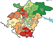
Ejura is a town and the capital of Ejura/Sekyedumase, a district in the Ashanti Region of Ghana. Ejura has settlement population of 70,807 people.[1] Ejura is the largest maize producing district in the Ashanti Region of Ghana. It is in the far north of the region, near the Afram River.[2] Ejura is connected by highways with the towns of Mampong, Yeji and Techiman.[2] Ejura is home to the Digya National Park / Kujani Game Reserve.[2]
References
- ^ a b "World Gazetteer online". World-gazetteer.com.
- ^ a b c "Ejura-Sekyedumase".
7°23′N 1°22′W / 7.383°N 1.367°W


