Galion, Ohio
Galion, Ohio | |
|---|---|
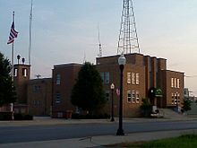
 Saint Joseph Catholic Church located on North Liberty Street | |
 Location of Galion, Ohio | |
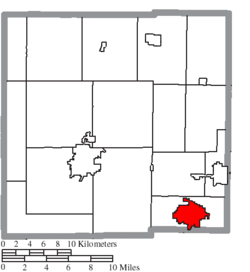
 Location of Galion in Crawford County | |
| Country | United States |
| State | Ohio |
| Counties | Crawford, Morrow, Richland[1] |
| Government | |
| • Type | Mayor Council |
| • Mayor | Mayor Tom O'Leary |
| Area | |
• Total | 7.63 sq mi (19.76 km2) |
| • Land | 7.61 sq mi (19.71 km2) |
| • Water | 0.02 sq mi (0.05 km2) |
| Elevation | 1,171 ft (357 m) |
| Population | |
• Total | 10,512 |
• Estimate (2012[5]) | 10,276 |
| • Density | 1,381.3/sq mi (533.3/km2) |
| Time zone | UTC-5 (Eastern (EST)) |
| • Summer (DST) | UTC-4 (EDT) |
| ZIP code | 44833 |
| Area code | 419 |
| FIPS code | 39-29162[6] |
| GNIS feature ID | 1064699[3] |
| Website | http://www.galion.city |
Galion is a city in Crawford, Morrow, and Richland counties in the U.S. state of Ohio. The population was 10,512 at the 2010 census. Galion is the second-largest city in Crawford County after Bucyrus.
The Crawford County portion of Galion is part of the Bucyrus Micropolitan Statistical Area. The small portion of the city that is located in Richland County is part of the Mansfield Metropolitan Statistical Area, while the portion extending into Morrow County is considered part of the Columbus Metropolitan Statistical Area.
History

Galion was laid out in 1831.[7] The etymology of the name Galion is uncertain.[8] A post office called Galion has been in operation since 1825.[9]
Geography
Galion is located in the southeastern corner of Crawford County at 40°43′59″N 82°47′19″W / 40.73306°N 82.78861°W (40.733164, -82.788586).[10]
According to the United States Census Bureau, the city has a total area of 7.63 square miles (19.76 km2), of which 7.61 square miles (19.71 km2) is land and 0.02 square miles (0.05 km2) is water.[2]
The Olentangy River begins near and runs through Galion, and then winds southward toward Columbus and eventually empties into the Scioto River.
Demographics
| Census | Pop. | Note | %± |
|---|---|---|---|
| 1860 | 1,966 | — | |
| 1870 | 3,523 | 79.2% | |
| 1880 | 5,635 | 59.9% | |
| 1890 | 6,326 | 12.3% | |
| 1900 | 7,282 | 15.1% | |
| 1910 | 7,214 | −0.9% | |
| 1920 | 7,374 | 2.2% | |
| 1930 | 7,674 | 4.1% | |
| 1940 | 8,685 | 13.2% | |
| 1950 | 9,952 | 14.6% | |
| 1960 | 12,650 | 27.1% | |
| 1970 | 13,123 | 3.7% | |
| 1980 | 12,424 | −5.3% | |
| 1990 | 11,859 | −4.5% | |
| 2000 | 11,341 | −4.4% | |
| 2010 | 10,512 | −7.3% | |
| 2015 (est.) | 10,127 | [11] | −3.7% |
| Sources:[6][12][13][14] | |||
2010 census
As of the census[4] of 2010, there were 10,512 people, 4,484 households, and 2,797 families residing in the city. The population density was 1,381.3 inhabitants per square mile (533.3/km2). There were 5,192 housing units at an average density of 682.3 per square mile (263.4/km2). The racial makeup of the city was 97.6% White, 0.5% African American, 0.1% Native American, 0.2% Asian, 0.4% from other races, and 1.1% from two or more races. Hispanic or Latino of any race were 1.3% of the population.
There were 4,484 households of which 30.8% had children under the age of 18 living with them, 43.7% were married couples living together, 14.2% had a female householder with no husband present, 4.5% had a male householder with no wife present, and 37.6% were non-families. 32.0% of all households were made up of individuals and 13.8% had someone living alone who was 65 years of age or older. The average household size was 2.32 and the average family size as 2.89.
The median age in the city was 39.7 years. 24.3% of residents were under the age of 18; 8.2% were between the ages of 18 and 24; 24.6% were from 25 to 44; 25.7% were from 45 to 64; and 17.3% were 65 years of age or older. The gender makeup of the city was 47.1% male and 52.9% female.
2000 census
As of the census[6] of 2000, there were 11,341 people, 4,791 households, and 3,090 families residing in the city. The population density was 2,286.5 people per square mile (882.8/km²). There were 5,150 housing units at an average density of 1,038.3 per square mile (400.9/km²). The racial makeup of the city was 98.28% White, 0.22% African American, 0.31% Native American, 0.26% Asian, 0.01% Pacific Islander, 0.35% from other races, and 0.56% from two or more races. Hispanic or Latino of any race were 0.93% of the population.
There were 4,791 households out of which 31.0% had children under the age of 18 living with them, 48.3% were married couples living together, 12.2% had a female householder with no husband present, and 35.5% were non-families. 30.7% of all households were made up of individuals and 13.6% had someone living alone who was 65 years of age or older. The average household size was 2.34 and the average family size was 2.90.

In the city the population was spread out with 25.5% under the age of 18, 8.5% from 18 to 24, 27.8% from 25 to 44, 22.2% from 45 to 64, and 16.0% who were 65 years of age or older. The median age was 37 years. For every 100 females there were 85.6 males. For every 100 females age 18 and over, there were 82.7 males.
The median income for a household in the city was $31,513, and the median income for a family was $38,554. Males had a median income of $32,517 versus $19,792 for females. The per capita income for the city was $16,113. About 11.9% of families and 14.7% of the population were below the poverty line, including 19.6% of those under age 18 and 11.3% of those age 65 or over.
Government
Galion has a Mayor-Council government: it is governed by an elected city council and mayor
Education
The Galion City School District encompasses the entire city of Galion, graduating about 150 students annually. There are a handful of neighborhoods outside of Galion that are also included in the school district, including Blooming Grove, birthplace of Warren G. Harding.
Media
Galion and neighboring communities are served by a semi-weekly newspaper, the Galion Inquirer.[citation needed]
Transportation

The Erie Railroad also ran through Galion and established large rail yards here, making the city an important rail center.
In April, 1851 the Cleveland Columbus and Cincinnati Railroad, later known as the "Big Four" and eventually the New York Central, began operating regular service between Columbus and Cleveland, stopping at Galion along the way. Prior to the end of the 19th century, Galion became a division headquarters for the line.
Galion boasted two large railroad depots, the Big Four Depot on Washington Street, and the Erie Depot on South Market Street, which was privately purchased and moved to the west side of Crestline, Ohio and is used as the main office of an auto wrecking yard. With the move of the Erie yards to Marion in the 1910s, the railroads declined, although the city remained a passenger rail center into the 1960s. The Big Four Depot was abandoned; however, it has since been acquired by the City of Galion and is undergoing a slow but thorough restoration.
From 1915 to 1923, Galion was on the original route of the Lincoln Highway, America's first coast-to-coast route. In later years, however, the northern route was improved and became US 30 North, although until approximately 1970 the route through Galion was designated as US 30 South. The new, four-lane US 30 opened in 2005, and passes just north of town, giving the community excellent transportation access.
State routes in Galion include 309, which connects Marion to the southwest with Ontario to the east; 598, which originates in Galion and stretches northward; 19, which heads westward toward the county seat and also south toward Williamsport; 61, which goes south towards Morrow and Delaware Counties and north to Lake Erie, and 97, which goes east through Lexington.
Industry


The Galion brand of heavy equipment (such as road graders, road rollers, and earthmovers) was manufactured in Galion Iron Works, later purchased by Dresser Industries and then by Komatsu. As of 2000, the plant in Galion operated with a reduced work force, and products manufactured there are no longer branded with the Galion name.
Galion was once the home of Peabody Galion, a manufacturer of sanitation equipment, primarily dump bodies, as well as front loading, side-loading and rear loading garbage trucks; rivaling the Heil Company for numbers of units sold throughout the world. For a short time, in the early 1970s, Peabody Galion maintained a manufacturing plant in Durant, Oklahoma, known as "Peabody Galion, Durant Division".
Galion was also once home to North Electric Company, a prime supplier of telephone switching systems for government and international markets. It was also producer of the Ericofon, the first ever one-piece telephone designed by Ralph Lysell and Hugo Blomberg. Founded in 1884 by Charles N. North, the company became part of Ericsson in 1951. It was purchased by ITT in the mid-1970s and operated as ITT PowerSystems until the late 1980s, when it was sold to a private consortium and renamed PECO II (the name is derived from North Electric Company's purchase of Power Equipment Company (PECO) in 1960). Peco II purchased the telecommunications product line and associated assets from ITT in 1988. In 2010, PECO II was acquired by Lineage Power of Plano, Texas and has since closed the plant.
Perfection Cobey was a manufacturer of dump truck bodies and other truck components.
Notable people
- Robert W. Morgan, radio personality, was from Galion.
References
- ^ "Subcounty population estimates: Ohio 2000-2008" (CSV). United States Census Bureau, Population Division. 2009-03-18. Retrieved 2009-04-04.
- ^ a b "US Gazetteer files 2010". United States Census Bureau. Retrieved 2013-01-06.
- ^ a b "US Board on Geographic Names". United States Geological Survey. 2007-10-25. Retrieved 2008-01-31.
- ^ a b "American FactFinder". United States Census Bureau. Retrieved 2013-01-06.
- ^ "Population Estimates". United States Census Bureau. Retrieved 2013-06-17.
- ^ a b c "American FactFinder". United States Census Bureau. Retrieved 2008-01-31.
- ^ History of Crawford County and Ohio. Baskin & Battey. 1881. p. 444.
- ^ Overman, William Daniel (1958). Ohio Town Names. Akron, OH: Atlantic Press. p. 49.
- ^ "Post offices". Jim Forte Postal History. Retrieved 11 June 2016.
- ^ "US Gazetteer files: 2010, 2000, and 1990". United States Census Bureau. 2011-02-12. Retrieved 2011-04-23.
- ^ "Annual Estimates of the Resident Population for Incorporated Places: April 1, 2010 to July 1, 2015". Retrieved July 2, 2016.
- ^ "Number of Inhabitants: Ohio" (PDF). 18th Census of the United States. U.S. Census Bureau. Retrieved 22 November 2013.
- ^ "Ohio: Population and Housing Unit Counts" (PDF). U.S. Census Bureau. Retrieved 22 November 2013.
- ^ "Incorporated Places and Minor Civil Divisions Datasets: Subcounty Population Estimates: April 1, 2010 to July 1, 2012". U.S. Census Bureau. Retrieved 25 November 2013.
- Galion Historical Society. The Historian: A Quarterly Newsletter and Collectible Journal, Vol. 7 Issue #4, June 2006, special 175th celebration edition.


