
Hailuoto
Template:Infobox Finnish municipality
Hailuoto (Swedish: Karlö) is an island and a municipality in Northern Ostrobothnia region, Finland. The population of Hailuoto is Template:Infobox Finnish municipality/population count (Error: Invalid time.)[1] and the municipality covers an area of [convert: invalid number] (excluding sea areas) of which [convert: invalid number] is inland water (Error: Invalid time.).[2] The population density is [convert: invalid number].
Hailuoto is located on an island of the same name opposite the city of Oulu in the Gulf of Bothnia. A ferry operates regularly between Hailuoto and Oulunsalo. In winter an official ice road connects the island to the mainland.
Land in the region is constantly rising due to post-glacial rebound. It is estimated that the first parts of Hailuoto appeared from the Baltic Sea about 1700 years ago. The current island of Hailuoto was formed from many smaller islands. Two large sections, Santonen and Hanhinen merged into the main island (Luoto) only about two centuries ago. The island is continuously expanding and eventually it will join with the continent. Kirkkosalmi, a wetland region between Hanhinen and Luoto is renowned for being an important bird refuge where rare bird species are observed.
Gallery
-
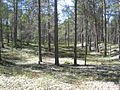 Typical forest in Hailuoto
 -
 Hailuoto Church, built in 1972
 -
 Old church, built in the 1610s, destroyed by fire in 1968
 -
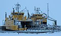 The ferries Meriluoto and Merisilta
 -
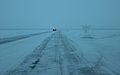 The ice road between the island and the mainland
 -
 Fishing boats in Marjaniemi


References
External links
 Media related to Hailuoto at Wikimedia Commons
- hailuototourism.fi
- Municipality of Hailuoto – Official site
 Hailuoto travel guide from Wikivoyage
- Ferry timetables
- Bothnian Bay Research Station of the University of Oulu
- Live webcam from the ferry
| Municipalities |  | |
|---|---|---|
| Former | ||