
Interstate 17
Interstate 17 | ||||
|---|---|---|---|---|
 | ||||
| Route information | ||||
| Maintained by ADOT | ||||
| Length | 145.76 mi[1] (234.58 km) | |||
| NHS | Entire route | |||
| Major junctions | ||||
| South end | ||||
| ||||
| North end | ||||
| Location | ||||
| Country | United States | |||
| State | Arizona | |||
| Highway system | ||||
| ||||
| ||||
.svg)
Interstate 17 (I-17) is an Interstate Highway located entirely within the state of Arizona, United States. I-17's southern terminus lies within Phoenix, at Interstate 10, and its northern terminus is in Flagstaff, at Interstate 40.[1] The majority of I-17 is known as the Arizona Veterans Highway. In the Phoenix metropolitan area, it is mostly known as the Black Canyon Freeway, however the southern 4.16 miles (6.69 km) is part of the Maricopa Freeway. The portion of the highway south of Cordes Lakes was built along the alignment of SR 69, while the northern part was built along old SR 79's alignment. I-17 is one of the most scenic Interstate Highways as it gains more than a mile in altitude between Phoenix at 1,117 feet (340 m) and Flagstaff at 7,000 feet (2,100 m). The highway features several scenic view exits along its route that overlook the many mountains and valleys found in northern Arizona.
Route description
Interstate 17 is known as the Black Canyon Freeway from the northern end of the Phoenix Metropolitan Area to a point 2.2 miles (3.5 km) south of The Stack interchange with Interstate 10 northwest of Downtown Phoenix. At the Durango Curve southwest of downtown, between the 19th Avenue and Buckeye Road interchanges, it picks up the designation Maricopa Freeway all the way to the southern terminus at the second Interstate 10 junction. It is one of the metropolitan area's primary freeways.[1][2]
I-17 has the unusual distinction of starting at approximately milepost 194 instead of at milepost zero. This is a holdover from Arizona's old system of marking mileposts, where a branching route would continue the milepost numbering of its original host, instead of starting over at zero. Interstate 17 inherited its milepost locations from SR 69, which the freeway replaced between Phoenix and Cordes Junction. SR 69's mileposting was such that it coincided with US 89's mileposting, which was 201.6 where the two routes intersected. When I-17 was constructed, the existing mileposting for SR 69 was retained.[1][2]
-
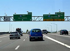
 "The Stack", intersection of Interstate 10 and I-17. Looking north up I-17, downtown Phoenix.
 -
-
 View of the Red Rocks of Sedona from I-17, just south of Munds Park
 -
 Interstate 17 near Flagstaff


History
In 1936, SR 69 was established as a state route from Phoenix north to Prescott.[3][4] The road was completed by 1940 to Prescott. In 1954, a new route north to Flagstaff was established as SR 79. By 1961, the roadway from Phoenix to Flagstaff had been established, but not to Interstate standards.[5] By 1971, I-17 had been completed from Phoenix northward to Camp Verde where a short stretch had not been completed to standards. The stretch from SR 279 north to SR 179 was also complete. The largest section yet to be completed was from SR 179 north to Flagstaff. This segment was still just a two-lane roadway, but it did have full traffic interchanges built at cross roads. The portion from I-40 south to the Flagstaff Municipal Airport had been completed by this time.[6]
The Islamic Community Center of Phoenix, which was founded in 1982, is located at 7516 North Black Canyon Highway, along Interstate 17.[7][8][9][10] It moved into that location in 1997.[7][11]
Bicycles and Pedestrians
Interstate 17 is closed to bicycles and pedestrians south of Pioneer Road (Exit 225) in the Anthem area and is open to bicycles and pedestrians north of this point.
Exit list
The entire route is in Arizona.
| County | Location | mi[1] | km | Exit | Destinations | Notes |
|---|---|---|---|---|---|---|
| Maricopa | Phoenix | 0.00 | 0.00 | 194 | Southern terminus, south end of US 60 overlap; exit 194 is for I-10 westbound, I-10 exit 150A; begin overlap with Maricopa Freeway | |
| 1.14 | 1.83 | 195A | 16th Street | Southbound exit and northbound entrance | ||
| 2.15 | 3.46 | 195B | 7th Street / Central Avenue | No signage for Central Ave. southbound | ||
| 3.16 | 5.09 | 196 | 7th Avenue / Central Avenue | No signage for Central Ave. northbound | ||
| 4.16 | 6.69 | 197 | 19th Avenue / Durango Street | Durango Curve; no signage for Durango St. northbound | ||
| End Maricopa Freeway, begin Black Canyon Freeway | ||||||
| 5.03 | 8.10 | 198 | Buckeye Road | Northbound exit only | ||
| 5.34 | 8.59 | 199A | Grant Street / Buckeye Road | No signage for Buckeye Rd. northbound | ||
| 5.73 | 9.22 | 199B | Jefferson Street | Southbound exit only | ||
| 5.88 | 9.46 | Adams Street / Van Buren Street | Northbound exit and entrance only | |||
| 6.49 | 10.44 | 200A | I-10 exits 143A-B | |||
| 7.05 | 11.35 | 200B | McDowell Road / Van Buren Street | No signage for Van Buren St. northbound | ||
| 8.09 | 13.02 | 201 | North end of US 60 overlap | |||
| 9.08 | 14.61 | 202 | Indian School Road | |||
| 10.08 | 16.22 | 203 | Camelback Road | |||
| 11.09 | 17.85 | 204 | Bethany Home Road | |||
| 12.09 | 19.46 | 205 | Glendale Avenue | |||
| 13.09 | 21.07 | 206 | Northern Avenue | |||
| 14.14 | 22.76 | 207 | Dunlap Avenue | |||
| 15.13 | 24.35 | 208 | Peoria Avenue | |||
| 16.13 | 25.96 | 209 | Cactus Road | |||
| 17.12 | 27.55 | 210 | Thunderbird Road | |||
| 18.12 | 29.16 | 211 | Greenway Road | |||
| 19.13 | 30.79 | 212 | Bell Road | |||
| 20.15 | 32.43 | 214A-B | Union Hills Drive / Yorkshire Drive | Signed separately as exits 214A (Union Hills Dr.) and 214B (Yorkshire Dr.) northbound | ||
| 21.11 | 33.97 | 214C | Loop 101 east exit 23, west exits 23B-C | |||
| 21.66– 22.16 | 34.86– 35.66 | 215 | Rose Garden Lane / Deer Valley Road | Signed as exit 215A northbound and exit 215B southbound | ||
| 23.27 | 37.45 | 217 | Pinnacle Peak Road | |||
| 24.19 | 38.93 | 218 | Happy Valley Road | |||
| 25.23 | 40.60 | 219 | Jomax Road | |||
| 27.25 | 43.85 | 220 | Dixileta Drive | Northbound exit and southbound entrance | ||
| 28.19 | 45.37 | 221 | ||||
| End Black Canyon Freeway | ||||||
| 29.17 | 46.94 | 222 | Dove Valley Road | Exit opened November 2013 | ||
| 30.17 | 48.55 | 223 | Signed as exits 223A (east) and 223B (west) northbound, eastern terminus of SR 74 | |||
| Anthem | 31.70 | 51.02 | 225 | Pioneer Road | ||
| 33.21 | 53.45 | 227 | Daisy Mountain Drive | |||
| 35.24 | 56.71 | 229 | Anthem Way | |||
| New River | 38.20 | 61.48 | 232 | New River | ||
| | 42.18 | 67.88 | 236 | Table Mesa Road | ||
| Yavapai | Black Canyon City | 48.29 | 77.72 | 242 | Black Canyon City, Rock Springs | |
| 50.56 | 81.37 | 244 | Black Canyon City | |||
| | 54.36 | 87.48 | 248 | Bumble Bee, Crown King | ||
| | 58.48 | 94.11 | Sunset Point Rest Area; exit 252 | |||
| | 61.85 | 99.54 | 256 | Badger Springs Road | The Mystery tree of Arizona is located south of this exit | |
| | 65.23 | 104.98 | 259 | Bloody Basin Road | ||
| Cordes Lakes | 68.44 | 110.14 | 262 | Northbound exit and southbound entrance | ||
| 68.77 | 110.67 | 263 | Northbound exit signed as Arcosanti Rd. only | |||
| | 74.53 | 119.94 | 268 | Orme Road / Dugas Road | ||
| | 84.16 | 135.44 | 278 | |||
| Camp Verde | 91.31 | 146.95 | 285 | General Crook Trail | ||
| 93.06 | 149.77 | 287 | ||||
| 95.74 | 154.08 | 289 | Montezuma Castle National Monument | |||
| | 99.04 | 159.39 | 293 | |||
| | 102.29– 102.36 | 164.62– 164.73 | McGuireville Rest Areas | |||
| | 104.75 | 168.58 | 298 | |||
| | 112.09 | 180.39 | 306 | Stoneman Lake Road | ||
| Coconino | | 121.37 | 195.33 | 315 | Rocky Park Road | |
| | 123.65 | 199.00 | 317 | Fox Ranch Road | ||
| | 126.29 | 203.24 | 320 | Schnebly Hill Road | ||
| | 128.51 | 206.82 | 322 | Munds Park | ||
| | 129.04 | 207.67 | Christensen Rest Areas; closed | |||
| | 132.01 | 212.45 | 326 | Willard Springs Road | ||
| | 134.55 | 216.54 | 328 | Newman Park Road | ||
| | 136.90 | 220.32 | 331 | Kelly Canyon Road | ||
| | 139.65 | 224.74 | 333 | Kachina Boulevard / Mountainaire Road | ||
| Flagstaff | 143.17 | 230.41 | 337 | South end of SR 89A overlap | ||
| 145.55 | 234.24 | 339 | Lake Mary Road – Mormon Lake | Northbound exit only | ||
| 145.76 | 234.58 | 340 | Northern terminus, north end of SR 89A overlap; continues north as SR 89A; signed as exits 340A (east) and 340B (west); I-40 exit 195 | |||
1.000 mi = 1.609 km; 1.000 km = 0.621 mi
| ||||||
See also
References
- ^ a b c d e Arizona Department of Transportation. "2008 ADOT Highway Log" (PDF). Retrieved April 30, 2008.
- ^ a b Google (February 15, 2008). "overview map of I-17" (Map). Google Maps. Google. Retrieved February 15, 2008.
- ^ Arizona and New Mexico Road Map (Map). Rand McNally. 1938. Retrieved November 27, 2011.
- ^ Arizona Department of Transportation. "ADOT Right-of-Way Resolution 1936-P-624". Retrieved April 22, 2008.
- ^ State Highway Department Road Map of Arizona (Map). Rand McNally. 1961. Retrieved November 27, 2011.
- ^ State Highway Department Road Map of Arizona (Map). Arizona State Highway Department. 1971. Retrieved November 27, 2011.
- ^ a b "About ICCP". ICCP.
- ^ Mohamed Nimer (2014). The North American Muslim Resource Guide: Muslim Community Life in the United States and Canada. Routledge.
- ^ Muhammad Sarwar (Shaikh.), Brandon Toropov (2003). The Complete Idiot's Guide to the Koran. Penguin.
- ^ "Phoenix mosque is a familiar FBI target". The Arizona Republic. May 7, 2015.
- ^ "Phoenix area Muslims building bridges after 9/11 attacks". The Arizona Republic.
External links
| Signed | |
|---|---|
| Unsigned | |
| Lists | |
| Other | |
Routes in italics are no longer a part of the system. Major Interstates are highlighted. | |