Irará
Appearance
Irará | |
|---|---|
Municipality | |
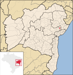
 Location in Bahia | |
Location in Brazil | |
| Coordinates: 12°02′45″S 38°45′57″W / 12.04583°S 38.76583°W | |
| Country | |
| Region | Northeast |
| State | Bahia |
| Mesoregion | Centro-Norte Baiano |
| Microregion | Feira de Santana |
| Founded | May 27th, 1842 |
| Incorporated (municipality) | August 8th, 1895 |
| Government | |
| • Mayor | Juscelino Souza |
| Area | |
| • Total | 267.88 km2 (103.43 sq mi) |
| Elevation | 283 m (928 ft) |
| Population (2010)[2] | |
| • Total | 29,879 |
| Time zone | UTC-3 (BRT) |
| CEP postal code | 44255-000 |
| Area code | 75 |
| HDI (2010) [1] | 0,620 |
| Website | irara.ba.gov.br |
Irará is a city in Bahia, Brazil. The municipality is the hometown of goalkeeper Dida, former of Milan goalkeeper and of Brazil national football team. Irara is the hometown of musician Tom Zé.
References
- ^ a b "Área dos municípios" [Area of the municipalities] (in Portuguese). Brazilian Institute of Geography and Statistics(IBGE). Retrieved 2018-04-13.
- ^ "Censo Populacional 2010" [Census 2010] (in Portuguese). Brazilian Institute of Geography and Statistics(IBGE). 2010-11-29. Archived from the original on 2011-05-16. Retrieved 2010-12-11.
{{cite web}}: Unknown parameter|deadurl=ignored (|url-status=suggested) (help)


