
Line 1 (São Paulo Metro)
You can help expand this article with text translated from the corresponding article in Portuguese. (April 2014) Click [show] for important translation instructions.
|
This article needs additional citations for verification. (February 2014) |
| São Paulo Metro Line 1 (Blue) | |||
|---|---|---|---|
| Overview | |||
| Status | Operational | ||
| Locale | São Paulo, Brazil | ||
| Termini | |||
| Stations | 23 | ||
| Service | |||
| Type | Rapid transit | ||
| System | São Paulo Metro | ||
| Operator(s) | Companhia do Metropolitano de São Paulo | ||
| History | |||
| Opened | September 14, 1974 | ||
| Technical | |||
| Line length | 20.2 kilometres (12.6 mi) | ||
| Track gauge | 1,600 mm (5 ft 3 in) 750 V DC third rail [1] | ||
| |||

Line 1 (Blue) was the first line built for the São Paulo Metro. It links Tucuruvi Station to Jabaquara Station. Construction began in the late 1960s and was completed in the early 1970s. It was also the first metro line built in Brazil.
History
Originally called North-South Line, line 1 began construction on December 14, 1968. Commercial operation began September 14, 1974, with trains running in the first seven kilometers between Jabaquara and Vila Mariana stations.
Stations
Gallery
-

-
 North Zone stations (Santana, Carandiru e Portuguesa-Tietê)
 -
 Budd-Mafersa train stopping at Santa Cruz Station
 -
Elevated line seen in the district of Santana.
-
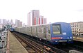 Railway line passing through Santana.
 -


Expansion plans
One expansion is planned from Tucuruvi to Cantareira. Another extension is planned from Jabaquara to Diadema.
References
- ^ Ferreira, Robert; Tharcisiu Alves. (January 2012). "São Paulo Metro". www.nycsubway.org. www.nycsubway.org. Archived from the original on 2014-02-02. Retrieved 2014-02-02.
On Lines 1, 2 and 3, the track gauge is a non standard 1600 mm, the third rail is 750 V DC and under running. For Lines 4 and 5, the track gauge is 1435 mm and they use overhead pantograph, precluding any connection to the rest of the system, plus the 4 and 5 lines can't connect because the trains on the 4 line use drive-less technology while trains on 5 line are OPTO. Lines 7, 8, 9, 10, 11 and 12 (operated by CPTM) are all 1600mm and use overhead pantograph.

| |
| |
| |
| |
| |