N72 road (Ireland)
Appearance
| N72 road | |
|---|---|
| Bóthar N72 | |
| Route information | |
| Length | 165.923 km (103.100 mi) |
| Location | |
| Country | Ireland |
| Primary destinations |
|
| Highway system | |
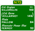
The N72 road is a national secondary road in Ireland that runs east-west from its junction with the N25 near Dungarvan in County Waterford to the N70 in Killorglin in County Kerry.
The road passes through Lismore – Fermoy (M8) – Mallow (N20) – Rathmore – Killarney (N22) – Killorglin.
The N72 is 165.923 km long.
Proposed upgrades
Funding of €2.4 million has been secured in 2011 for realignment of a particularly accident-prone stretch of the N72. [1]
See also
References
-
N72 entering Castletownroche from the east
-
Floods on the N72 near Killavullen
-
N72 approaching Mallow from the east


