
Nazca lines: Difference between revisions
m Reverted edits by 98.23.98.212 (talk) identified as unconstructive (HG) |
|||
| Line 22: | Line 22: | ||
==History== |
==History== |
||
C==MATTHEW WAZ HERE aka(sloppyjoe)8==D --- ontrary to the popular belief that the lines and figures can only be seen with the aid of flight, they are visible from atop the surrounding foothills. They were first discovered by the Peruvian archaeologist Toribio Mejia Xesspe, who spotted them when hiking through the foothills in 1927. He discussed them at a conference in Lima in 1939.<ref name="reece"/> |
|||
[[Paul Kosok]], a historian from Long Island University, is credited as the first scholar to seriously study the Nazca Lines. In the country in 1940-41 to study ancient irrigation systems, he flew over the lines and realized that one was in the shape of a bird. Another chance helped him see how lines converged at the winter solstice in the Southern Hemisphere. He began to study how the lines might have been created, as well as to try to determine their purpose. He was joined by [[Maria Reiche]], a German mathematician and archaeologist to help figure out the purpose of the Nazca Lines. They proposed one of the earliest reasons for the existence of the figures: to be markers on the horizon to show where the sun and other celestial bodies rose. Archaeologists, historians and mathematicians have all struggled with determining the purpose of the lines. |
[[Paul Kosok]], a historian from Long Island University, is credited as the first scholar to seriously study the Nazca Lines. In the country in 1940-41 to study ancient irrigation systems, he flew over the lines and realized that one was in the shape of a bird. Another chance helped him see how lines converged at the winter solstice in the Southern Hemisphere. He began to study how the lines might have been created, as well as to try to determine their purpose. He was joined by [[Maria Reiche]], a German mathematician and archaeologist to help figure out the purpose of the Nazca Lines. They proposed one of the earliest reasons for the existence of the figures: to be markers on the horizon to show where the sun and other celestial bodies rose. Archaeologists, historians and mathematicians have all struggled with determining the purpose of the lines. |
||
Revision as of 17:13, 8 April 2013
14°43′00″S 75°08′00″W / 14.71667°S 75.13333°W
| UNESCO World Heritage Site | |
|---|---|
 | |
| Criteria | Cultural: i, iii, iv |
| Reference | 700 |
| Inscription | 1994 (18th Session) |
The Nazca Lines /ˈnæzkə/ are a series of ancient geoglyphs located in the Nazca Desert in southern Peru. They were designated as a UNESCO World Heritage Site in 1994. The high, arid plateau stretches more than 80 kilometres (50 mi) between the towns of Nazca and Palpa on the Pampas de Jumana about 400 km south of Lima. Although some local geoglyphs resemble Paracas motifs, scholars believe the Nazca Lines were created by the Nazca culture between 400 and 650 AD.[1] The hundreds of individual figures range in complexity from simple lines to stylized hummingbirds, spiders, monkeys, fish, sharks, orcas, and lizards.
The lines are shallow designs made in the ground by removing the reddish pebbles and uncovering the whitish/grayish ground beneath. Hundreds are simple lines or geometric shapes; more than seventy are zoomorphic designs of animals such as birds, fish, llamas, jaguar, monkey, or human figures. Other designs include phytomorphic shapes such as trees and flowers. The largest figures are over 200 metres (660 ft) across. Scholars differ in interpreting the purpose of the designs, but in general they ascribe religious significance to them. Other theories have been summarized as follows:
"The geometric ones could indicate the flow of water or be connected to rituals to summon water. The spiders, birds, and plants could be fertility symbols. Other possible explanations include: irrigation schemes or giant astronomical calendars."[2]
Due to the dry, windless, and stable climate of the plateau and its isolation, for the most part the lines have been preserved. Extremely rare changes in weather may temporarily alter the general designs. As of recent years, the lines have been deteriorating due to an influx of squatters inhabiting the lands. [3]
History
C==MATTHEW WAZ HERE aka(sloppyjoe)8==D --- ontrary to the popular belief that the lines and figures can only be seen with the aid of flight, they are visible from atop the surrounding foothills. They were first discovered by the Peruvian archaeologist Toribio Mejia Xesspe, who spotted them when hiking through the foothills in 1927. He discussed them at a conference in Lima in 1939.[4]
Paul Kosok, a historian from Long Island University, is credited as the first scholar to seriously study the Nazca Lines. In the country in 1940-41 to study ancient irrigation systems, he flew over the lines and realized that one was in the shape of a bird. Another chance helped him see how lines converged at the winter solstice in the Southern Hemisphere. He began to study how the lines might have been created, as well as to try to determine their purpose. He was joined by Maria Reiche, a German mathematician and archaeologist to help figure out the purpose of the Nazca Lines. They proposed one of the earliest reasons for the existence of the figures: to be markers on the horizon to show where the sun and other celestial bodies rose. Archaeologists, historians and mathematicians have all struggled with determining the purpose of the lines.
Determining how they were made has been easier than figuring why they were made. Scholars have theorized the Nazca people could have used simple tools and surveying equipment to construct the lines. Archaeological surveys have found wooden stakes in the ground at the end of some lines, which support this theory. One such stake was carbon-dated and was the basis for establishing the age of the design complex. The scholar Joe Nickell of the University of Kentucky has reproduced the figures by using tools and technology available to the Nazca people. The National Geographic called his work "remarkable in its exactness" when compared to the actual lines.[5] With careful planning and simple technologies, a small team of people could recreate even the largest figures within days, without any aerial assistance.[4]
On the ground, most of the lines are formed by a shallow trench with a depth of between 10 cm (3.9 in) and 15 cm (5.9 in). Such trenches were made by removing the reddish-brown iron oxide-coated pebbles that cover the surface of the Nazca desert. When this gravel is removed the light-colored clay earth which is exposed in the bottom of the trench produces lines which contrast sharply in color and tone with the surrounding land surface. This sublayer contains high amounts of lime which, with the morning mist, hardens to form a protective layer that shields the lines from winds, thereby preventing erosion.
The Nazca "drew" several hundred simple but huge curvilinear animal and human figures by this technique. In total, the earthwork project is huge and complex: the area encompassing the lines is nearly 500 square kilometres (190 sq mi), and the largest figures can span nearly 270 metres (890 ft). Some of the measurements for the figures include that the Hummingbird is 93 meters (310 ft) long, the Condor is 134 meters (440 ft), the Monkey is 93 meters (310 ft) by 58 meters (190 ft), and the Spider is 47 meters (150 ft). The extremely dry, windless, and constant climate of the Nazca region has preserved the lines well. The Nazca desert is one of the driest on Earth and maintains a temperature around 25 °C (77 °F) all year round. The lack of wind has helped keep the lines uncovered and visible to the present day.
The discovery of two new small figures was announced in early 2011 by a Japanese team from Yamagata University. One of these resembles a human head and is dated to the early period of Nazca culture or earlier and the other, undated, an animal. In March 2012 the university announced that a new research center would be opened at the site in September 2012 to study the area for the next 15 years.The team has been doing field work there since 2006 when it found about 100 new geoglyphs.[6][7]
In 2013, it was reported machinery used in a limestone quarry had destroyed a small section of a line, and caused damage to another.[8]

Purpose
Archeologists, ethnologists, and anthropologists have studied the ancient Nazca culture to try to determine the purpose of the lines and figures. One hypothesis is that the Nazca people created them to be seen by their gods in the sky. Kosok and Reiche advanced a purpose related to astronomy and cosmology: the lines were intended to act as a kind of observatory, to point to the places on the distant horizon where the sun and other celestial bodies rose or set in the solstices. Many prehistoric indigenous cultures in the Americas and elsewhere constructed earthworks that combined such astronomical sighting with their religious cosmology, as did the later Mississippian culture at Cahokia in present-day United States. Another example is Stonehenge in England.
But Gerald Hawkins and Anthony Aveni, experts in archaeoastronomy, concluded in 1990 that there was insufficient evidence to support such an astronomical explanation.[9]
Reiche asserted that some or all of the figures represented constellations. By 1998, Phyllis B. Pitluga, a protégé of Reiche and senior astronomer at the Adler Planetarium in Chicago, had concluded that the animal figures were "representations of heavenly shapes. But she contends that they are not shapes of constellations but of what might be called counter constellations, the irregular-shaped dark patches within the twinkling expanse of the Milky Way."[10] Aveni criticized her work for failing to account for all the details.
In 1985, the archaeologist Johan Reinhard published archaeological, ethnographic, and historical data demonstrating that worship of mountains and other water sources predominated in Nazca religion and economy from ancient to recent times. He theorized that the lines and figures were part of religious practices involving the worship of deities associated with the availability of water, which directly related to the success and productivity of crops. He interpreted the lines as sacred paths leading to places where these deities could be worshiped. The figures were symbols representing animals and objects meant to invoke the gods' aid in supplying water. The precise meanings of many of the individual geoglyphs remain unsolved as of 2013.
Henri Stierlin, a Swiss art historian specializing in Egypt and the Middle East, published a book in 1983 linking the Nazca Lines to the production of ancient textiles that archeologists have found wrapping mummies of the Paracas culture.[11] He contended that the people may have used the lines and trapezes as giant, primitive looms to fabricate the extremely long strings and wide pieces of textile that are typical of the area. By his theory, the figurative patterns (smaller and less common) were meant only for ritualistic purposes. This theory is not widely accepted, although scholars have noted similarities in patterns between the textiles and the Nazca Lines, which they take as sharing in a common culture.
Alternative explanations

Phyllis Pitluga, senior astronomer at the Adler Planetarium & Astronomy Museum and a protégé of Reiche, did computer-aided studies of star alignments. She asserted that the giant spider figure is an anamorphic diagram of the constellation Orion. She further suggested that three of the straight lines leading to the figure were used to track the changing declinations of the three stars of Orion's Belt. In a critique of her analysis, Dr. Anthony F. Aveni noted that she did not account for the other twelve lines of the figure; he commented generally on her conclusions, saying:
I really had trouble finding good evidence to back up what she contended. Pitluga never laid out the criteria for selecting the lines she chose to measure, nor did she pay much attention to the archaeological data Clarkson and Silverman had unearthed. Her case did little justice to other information about the coastal cultures, save applying, with subtle contortions, Urton's representations of constellations from the highlands. As historian Jacquetta Hawkes might ask: was she getting the pampa she desired?[12]
Some individuals propose alternative hypotheses. The Swiss author Erich von Däniken suggests the Nazca lines and other complex constructions represent higher technological knowledge than commonly believed to be existing when the glyphs were created. Von Däniken maintains that the Nazca lines in Peru are runways of an ancient airfield that was used by extraterrestrials mistaken by the natives to be their gods. His theory has not been accepted by scholars.
Jim Woodmann believes that the Nazca Lines could not have been made without some form of manned flight to see the figures properly. Based on his study of available technology, he suggests that a hot air balloon was the only possible means of flight. To test this hypothesis, Woodmann made a hot-air balloon using materials and techniques that he understood to be available to the Nazca people. The balloon flew, after a fashion. Most scholars have rejected Woodmann's thesis as ad hoc,[4] because of the lack of any evidence of such balloons.[13]
Environmental concerns
People trying to preserve the Nazca Lines are concerned about threats of pollution and erosion caused by deforestation in the region.
The Lines themselves are superficial, they are only 10 to 30 cm deep and could be washed away... Nazca has only ever received a small amount of rain. But now there are great changes to the weather all over the world. The Lines cannot resist heavy rain without being damaged.
Template:Nb10– Viktoria Nikitzki of the Maria Reiche Centre[14]
After flooding and mudslides in the area in mid-February 2007, Mario Olaechea Aquije, archaeological resident from Peru's National Institute of Culture, and a team of specialists surveyed the area. He said, "[T]he mudslides and heavy rains did not appear to have caused any significant damage to the Nazca Lines," but the nearby Southern Pan-American Highway did suffer damage, and "the damage done to the roads should serve as a reminder to just how fragile these figures are."[15]
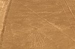
Images
-
 The Hummingbird
 -
 The Condor
 -
 The Heron
 -
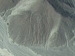 The "Giant"
 -
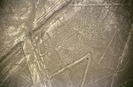 The Spider
 -
 The Pelican
 -
 The Dog
 -
 The Hands
 -
 The Monkey


See also
- Iperu, tourist information and assistance
- Tourism in Peru
- Maria Reiche
- Marilyn Bridges
- Simone Waisbard
- List of archaeoastronomical sites sorted by country
Notes
- ^ Helaine Silverman, David Browne (1991). "New evidence for the date of the Nazca lines". Antiquity. 65 (247): 208–220.
- ^ Brown, Cynthia Stokes (2007). Big History. New York: The New Press. p. 167. ISBN 978-1-59558-196-9.
- ^ Taj, Mitra. August 15, 2012. Pigs and squatters threaten Peru's Nazca lines. Reuters. Accessed on August 15, 2012. http://www.reuters.com/article/2012/08/15/us-peru-nazca-squatters-idUSBRE87E0R520120815.
- ^ a b c Katherine Reece, "Grounding the Nasca Balloon", Into the Hall of Ma'at website
- ^ Nickell, Joe (2005). Unsolved History: Investigating Mysteries of the Past, The University Press of Kentucky ISBN 978-0-8131-9137-9, pp. 13-16
- ^ "Team finds more Peru geoglyphs". Japan Times. Jan. 20, 2011. Retrieved 9 April 2012.
{{cite news}}: Check date values in:|date=(help) - ^ "University to open center at Nazca Lines". Japan Times. March 22, 2012. Retrieved 9 April 2012.
- ^ http://www.peruthisweek.com/news-3743-peru-heavy-machinery-destroys-nazca-lines/
- ^ Cameron, Ian (1990). Kingdom of the Sun God: A History of the Andes and Their People. New York: Facts on File. p. 46. ISBN 0-8160-2581-9.
- ^ ROBERT McG. THOMAS Jr, "Maria Reiche, 95, Keeper of an Ancient Peruvian Puzzle, Dies", New York Times, 15 June 1998
- ^ Stierlin (1983)
- ^ Aveni, Anthony F. Between the Lines: The Mystery of the Giant Ground Drawings of Ancient Nasca, Peru . Austin, Texas: University of Texas Press. 1 July 2006 ISBN 0-292-70496-8 p.205 [1]
- ^ Haughton (2007)
- ^ Shafik Meghji, "Flooding and tourism threaten Peru's mysterious Nazca Lines", The Independent, July 17, 2004. Accessed April 02, 2007.
- ^ Living in Peru. "Peru: Nazca Lines escape mudslides", Living in Peru, February 20, 2007. Accessed April 02, 2007.
References
- Aveni, Anthony F. (ed.) (1990). The Lines of Nazca. Philadelphia: American Philosophical Society. ISBN 0-87169-183-3
- Haughton, Brian. (2007). Hidden History: Lost Civilizations, Secret Knowledge, and Ancient Mysteries. Career Press. ISBN 1-56414-897-1
- Lambers, Karsten (2006). The Geoglyphs of Palpa, Peru: Documentation, Analysis, and Interpretation. Lindensoft Verlag, Aichwald/Germany. ISBN 3-929290-32-4
- Reinhard, Johan (1996) (6th ed.) The Nazca Lines: A New Perspective on their Origin and Meaning. Lima: Los Pinos. ISBN 84-89291-17-9
- Sauerbier, Martin. GIS-based Management and Analysis of the Geoglyphs in the Palpa Region. ETH (2009). doi:10.3929/ethz-a-005940066.
- Stierlin, Henri (1983). La Clé du Mystère. Paris: Albin Michel. ISBN 2-226-01864-6
Further reading
- Johnson, Emma. 2007. The 'Mysterious' Nazca Lines. PARA Web Bibliography B-01.
- Kosok, Paul (1965). Life, Land and Water in Ancient Peru, Brooklyn: Long Island University Press.
- von Däniken, Erich (2003). Arrival of the Gods: Revealing the Alien Landing Sites of Nazca. Vega, London. ISBN 1-84333-053-9; first published (1977) as Zeichen für die Ewigkeit, Bertelsmann Verlag, Munich.
- Nickell, Joe. 1983. Skeptikal Inquirer The Nazca Lines Revisited: Creation of a Full-Sized Duplicate.
External links
- Nazca Designs and Lines at Discover Peru
- Nazca Lines photos
- Tragedies flying over the Nazca lines
- Template:Dmoz
- Nazca Lines in Google Earth
| Cultural |
| |
|---|---|---|
| Natural | ||
| Mixed |
| |