Nendö (island)


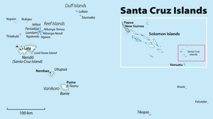
Nendo (or more exactly Nendö) is the largest of the Santa Cruz Islands, located in the Temotu province of the Solomon Islands. The island is also known as Santa Cruz, Ndeni, Nitendi or Ndende. The name Santa Cruz was given to the island in 1595 by the Spanish navigator Álvaro de Mendaña, who unsuccessfully started a colony there.
Geography
Located at (10°25'12" S. lat., 165°30' E. long.), Nendö is 40 km (25 mi.) long and 22 km (14 mi.) wide. Its land area is 505.5 km² (195 sq. mi.). The highest point on the island is 549 m (1,801 ft.) above sea level.
The two small islands of Malo and Nibanga (also called Tömotu Neo and Tömotu Noi), lie about 1 km (0.6 mi.) distant: Malo to the northwest, Nibanga to the southeast.
Lata, located in the northwestern part of the island, is its chief town and the provincial capital.
Population and languages
Nendö's population is somewhat over 5000. Most indigenous Nendö people are speakers of Natügu, but there are also about 200 speakers of the related Nanggu language (both members of the Reefs – Santa Cruz languages family). Speakers of other Temotu province languages are also present, for example the other Reefs – Santa Cruz language Äiwoo and the Polynesian outlier language Vaeakau-Taumako.
Culture

In 1966-67 Gerd Koch, a German anthropologist, carried out field studies on the culture of Nendö and other Santa Cruz Islands. In 1971 Koch published Die Materielle Kultur der Santa Cruz-Inseln.[1] Koch brought back to the Ethnological Museum of Berlin the last still complete Tepukei (ocean-going outrigger canoe) from the Santa Cruz Islands.[2]
History
Attempting to return to the Solomon Islands, that he had discovered in 1568, Spanish explorer Álvaro de Mendaña in his second trip of 1595, discovered Nendo Island on 8 September 1595, which they named Santa Cruz. Mendaña landed at what they named Graciosa Bay (still its name today), and a settlement was commenced. Relations with local islanders and their chief Malope started well, with food provided and assistance in constructing buildings. However, morale amongst the Spanish was low and sickness (almost certainly malaria) was rife. At that point some soldiers deliberately murdered villagers in order to provoke hostilities and so force the abandonment of the colony, and seditious petitions were signed. Mendaña took action, and at his behest Maestre de Campo Pedro Merino Manrique, leader of the malcontents, was cut down in his presence, and on the same day the Spaniards' best friend, Malope, was murdered by some of Manrique's gang.[3]
Wracked by internal divisions and an increasing death toll, the settlement began to fall apart. Mendaña himself died on 18 October 1595, leaving his wife Isabel Barreto as heir and governor, her brother Lorenzo Barreto as captain-general. On 30 October, the decision was made to abandon the settlement. When the three ships departed on 18 November 1595, forty-seven people had died in the space of one month, and the first European colony in the South Seas was ended.[4]
Earthquakes
Due to the island’s location along the Ring of Fire, earthquakes are frequent, and range from 4.0 to 8.0. Some major earthquakes happened between 8 and 25 February 2013.[5]
References
- ^ Koch, Gerd (1971). Die Materielle Kultur der Santa Cruz-Inseln (in German). Berlin: Museum fur Volkerkunde Ethnological Museum of Berlin.
{{cite book}}: Cite has empty unknown parameter:|month=(help) - ^ "Short Portrait: Gerd Koch". Interviews with German anthropologists: The History of Federal German Anthropology post 1945. 20 December 2012. Retrieved 5 February 2014.
- ^ Spate, Oskar H.K. The Spanish Lake, Australian National University, (Second Edition 2004) p.188 ISBN 1-920942-17-3
- ^ Estensen, Miriam Terra Australis Incognita; The Spanish Quest for the Mysterious Great South Land, Allen & Unwin, Australia, (2006) p.85. ISBN 1-74175-054-7
- ^ Huge Aftershock Shakes Solomon Islands Again – 10 Feb 2013.
External links
- A Nendo folktale collected and translated by Robert Viking O'Brien from Marvels & Tales: Journal of Fairy-Tale Studies
- Google Maps
