
Nizamuddin West

Nizamuddin West (Urdu: مغربی نظام الدین) is a historic neighbourhood and one the colonies of South Delhi across Hazrat Nizamuddin Railway Station.
History
This relatively affluent locality is named after 13th century Sufi saint, Hazrat Nizamuddin Auliya, whose shrine or dargah in Urdu is situated within the area. Nizamuddin West is a colony that is relatively affluent and the Residential Welfare Association (RWA) of Nizamuddin is working to make it more secure and peaceful area for the local residents.
Overview
The colony is divided into six blocks and has the main entry point near the petrol pump at the Mathura Road. The area is greener because it has a lot of parks. Nizamuddin Basti (Village) is in the close vicinity of this area.
This colony is regarded as one of the posh colonies. The colony has been home to noted freedom fighters in the past. The first Chief Executive Councillor of Delhi and veteran freedom fighter Padma Shri Mir Mushtaq Ahmad resided here. Amarnath Vidyalankar, freedom fighter and former MP was also a resident. The prices of the houses in this area are on a steady rise.
Historic sites
- The tomb of Nizamuddin Auliya[1]
- The Jama 'at-Khana-Masjid or Khilji mosque[1] built by built in 1325 by Khizr Khan, son of Alauddin Khilji[2]
- The shrine to Amir Khusrow[1]
- The grave of the 19th-century Urdu poet Mirza Ghalib and the adjacent Ghalib Academy
- The tomb of Khan i Jahan Tilangani.[3]
- Kalan Masjid.
-
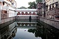 Nizamudin Baoli

See also
Notes
- ^ a b c Saniotis, Arthur (2008). "Enchanted Landscapes: Sensuous Awareness as Mystical Practice among Sufis in North India". The Australian Journal of Anthropology. 19 (1): 17–26. doi:10.1111/j.1835-9310.2008.tb00103.x.
- ^ "Hazrat Nizamuddin Auliya Dargah (Nizamu'din)". India Infoweb. 2008. Archived from the original on 9 June 2008.
{{cite web}}: Unknown parameter|deadurl=ignored (|url-status=suggested) (help) - ^ Sanatani, Rohit Priyadarshi. "The Tomb of Khan - i Jahan Tilangani: A forgotten gem". The Speaking Arch. Retrieved 28 March 2015.
28°35′N 77°15′E / 28.583°N 77.250°E
This article related to a location in the Indian state of Delhi is a stub. You can help Wikipedia by expanding it. |