
Puerto Rico Highway 66
This article needs additional citations for verification. (September 2014) |
Highway 66 | ||||
|---|---|---|---|---|
| Ruta 66 | ||||
| Roberto Sánchez Vilella Expressway | ||||
| Route information | ||||
| Maintained by Puerto Rico Department of Transportation (DTOP) | ||||
| Length | 12.42 mi (19.99 km) | |||
| Existed | November 12,2000 Mid segment March 2006–present | |||
| Major junctions | ||||
| East end | ||||
| West end | ||||
| Location | ||||
| Country | United States | |||
| Territory | Puerto Rico | |||
| Highway system | ||||
| ||||


Puerto Rico Highway 66 (unsigned Interstate PR3) is a main tollway which parallels Puerto Rico Highway 3 going from the city of Carolina, Puerto Rico via a 3 loops cloverleaf interchange with PR-26 and PR-3, a major exit in the form of a Trumpet interchange in Canóvanas, Puerto Rico and ending in the municipality of Río Grande, Puerto Rico with an intersection of PR-3. It is only 12.42 miles (19.99 km) long and has very few exits, which work mainly to minimize traffic in the congested Carolina area of PR-3.[citation needed]
The highway is called the Roberto Sánchez Vilella Expressway, which is also the name given to the much larger PR-2 freeway segment from Hormigueros to Ponce. The second phase of PR-66 from Canóvanas to Rio Grande was opened on October 1, 2012.[2]
Toll Plazas
| Location | Toll | Direction | AutoExpreso acceptance |
AutoExpreso replenishment (R) lane |
|---|---|---|---|---|
| Plaza Carolina | $1.50 | Two-way | ||
| Rampa Norte | $0.75 | Two-way(ramp) | ||
| Rampa Sur | $0.75 | Two-way(ramp) | ||
| Río Grande | $1.00 | Two-way |
Route description

Naming
PR-66 is, in reality, an extension of older expressway PR-26, as both expressways are attached (that is, there is no need to take an exit to enter the other expressway, much like PR-18 and PR-52). PR-66 was assigned that number after U.S. Route 66 in the United States.[citation needed]
Controversy
PR-66 is very close to the El Yunque National Forest and at the beginning caused problems between developers and environmental activists. Several actions of disobedience took place, including beams already installed being removed.[citation needed] The expressway was planned to be extended to Fajardo but due to the close presence of the forest reserve, it was accorded to be extended to Río Grande and connect to PR-3 which has several exits between that municipality and Fajardo, and it might be possible that PR-3 is converted into a complete freeway in that segment as it approaches PR-53.[citation needed]

The short expressway is very expensive in terms of toll fees and many people still go through PR-3 as a consequence. There are no plans to turn the booth tolls down or lower the current fee of $1.50 and $1.00 respectively. This makes this small freeway the second most expensive tollway in the US (excluding bridges and tunnels), after the Dulles Greenway in Virginia in terms of its small length, about 30 cents per mile (19 ¢/km). This results beneficial in the effect that PR-66 has low traffic almost all the time, including rush hours.[citation needed] As of December 2011, the toll must be paid by pre-paid AutoExpreso.[3]
Puerto Rico Highway 26
Highway 26 | |
|---|---|
| Location | Carolina – San Juan |
| Length | 9.32 mi (15.00 km) |
| Existed | 1982 And Completed In 1999–present |
Puerto Rico Highway 26, called the Román Baldorioty de Castro Expressway, is the main highway to the Luis Muñoz Marín International Airport and is connected to PR-66. It was converted to a freeway to minimize the traffic in PR-3 and PR-17, to grant better access to the Airport.[citation needed] Several exits exist to provide access to PR-187 (the main route to the Piñones area), PR-37 (Isla Verde) and PR-22 (José de Diego). The combined routes of PR-26 and PR-66 is about 21.74 miles (34.99 km) long.
-
 Puerto Rico Highway 26 in Isla Verde.
 -

-
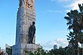 Statue of Román Baldorioty de Castro in PR-26.


References
- ^ https://maps.google.com/maps?saddr=Expreso+Rom%C3%A1n+Baldorioty+de+Castro&daddr=18.375514,-65.82742+to:Ruta+desconocida&hl=es-419&ie=UTF8&ll=18.38499,-65.903721&spn=0.100835,0.169086&sll=18.394133,-65.979702&sspn=0.006302,0.010568&geocode=FW2xGAEdtDwR_A%3BFVpjGAEdpI0T_ClF53reSJ4EjDG799l99pHjmA%3BFTJjGAEdqpUT_A&t=h&mra=dme&mrsp=0&sz=17&via=1&z=13&layer=t
- ^ http://www.elnuevodia.com/fortunoinauguranuevotramodelaruta66-1354194.html
- ^ https://www.autoexpreso.com/CustWebApp/WebIndex.jsp
- ^ https://maps.google.com/maps?saddr=PR-1&daddr=Expreso+Rom%C3%A1n+Baldorioty+de+Castro&hl=es-419&ie=UTF8&sll=18.457323,-66.086175&sspn=0.00315,0.005284&geocode=FdGkGQEdhpgP_A%3BFW2xGAEdtDwR_A&t=h&mra=prev&z=13&layer=t
External links
- Hawaii Highways – Puerto Rico Interstate Photographs (2002)
| Signed | |
|---|---|
| Unsigned | |
| Lists | |
| Other | |
Routes in italics are no longer a part of the system. Major Interstates are highlighted. | |