
Sison, Pangasinan
Sison | |
|---|---|
 | |
 Seal | |
 Location in the province of Pangasinan | |
| Country | Philippines |
| Region | Ilocos (Region I) |
| Province | Pangasinan |
| District | 5th district of Pangasinan |
| Barangays | 28 |
| Government | |
| • Mayor | Mina Joy C. Pangasinan |
| Area | |
| • Total | 81.88 km2 (31.61 sq mi) |
| Population (2010)[3] | |
| • Total | 43,979 |
| • Density | 540/km2 (1,400/sq mi) |
| Time zone | UTC+8 (PST) |
| ZIP code | 2434 |
| Dialing code | 75 |
| Income class | 3rd class; rural |
| Website | www |
Sison (Pangasinan: Baley na Sison; Ilocano: Ili ti Sison), is a third class and northernmost municipality in the province of Pangasinan, Philippines. According to the 2010 census, it has a population of 43,979 people.[3]
It was formerly called Alava.[4][5]
Geography
It is geographically located on the northern portion of Pangasinan, bordering the provincial boundaries of La Union and Benguet. It has a total land area of 81.88 square kilometers. It is bounded on the north by Rosario (La Union), Tuba (Benguet); on the south by Pozorrubio; on the southeast by San Manuel and Binalonan; on the west by San Fabian .
The municipality is 207 kilometres (129 mi) north of Manila, 62 kilometres (39 mi) south of San Fernando City, where the regional office of the national government agencies in Region I are located, 53 kilometres (33 mi) east of Lingayen (via Pozorrubio), the capital of Pangasinan, and 43 kilometres (27 mi) south of Baguio City.
Barangays
| Rank | Barangay | Population | Rank | Barangay | Population | |
|---|---|---|---|---|---|---|
| 1 | Paldit | 3,630 | 16 | Pindangan | 1,416 | |
| 2 | Labayug | 2,821 | 17 | Alibeng | 1,402 | |
| 3 | Asan Sur | 2,678 | 18 | Bantay Insik | 1,345 | |
| 4 | Asan Norte | 2,191 | 19 | Agat | 1,284 | |
| 5 | Poblacion Norte | 1,987 | 20 | Inmalog | 1,244 | |
| 6 | Sagunto | 1,916 | 21 | Tara-tara | 1,205 | |
| 7 | Esperanza | 1,861 | 22 | Poblacion Sur | 1,118 | |
| 8 | Killo | 1,618 | 23 | Artacho | 1,097 | |
| 9 | Pinmilapil | 1,614 | 24 | Camangaan | 1,021 | |
| 10 | Binmeckeg | 1,587 | 25 | Bulaoen West | 1,000 | |
| 11 | Cabaritan | 1,547 | 26 | Bulaoen East | 902 | |
| 12 | Bila | 1,524 | 27 | Calunetan | 824 | |
| 13 | Cauringan | 1,509 | 28 | Amagbagan | 710 | |
| 14 | Poblacion Central | 1,478 | Sison Total | 43,979 | ||
| 15 | Dungon | 1,450 | ||||
History
Sison originated from San Fabian, that is, from Bulaoen, then into Alava in 1862 and finally to Poblacion, the present site. In 1907, Esperanza, north-east of Alava, was formed into Pinmilapil, Agat, Sagunto, Cauringan, Bila and Colisao (now in San Fabian). Labayug was formed also into Inmalog, Calunetan, San Andres, Alibeng, Bacayao and Killo.
Esperanza and Labayug were joined as Artacho, its Poblacion. The former town of Alava had been in a move to expand its jurisdiction. The township of Artacho had also a move to become a regular municipality. As a result of their efforts, they fused as one. Senator Pedro Ma. Sison sponsored the town's birth while Governor Wood decreed Sison, Pangasinan as a new town on May 11, 1918.[7]
Demographics
| Year | Pop. | ±% p.a. |
|---|---|---|
| 1990 | 32,892 | — |
| 1995 | 35,625 | +1.51% |
| 2000 | 40,955 | +3.03% |
| 2007 | 42,791 | +0.61% |
| 2010 | 43,979 | +1.00% |
| Source: National Statistics Office[3][8] | ||
Climate
| Climate data for Sison, Pangasinan | |||||||||||||
|---|---|---|---|---|---|---|---|---|---|---|---|---|---|
| Month | Jan | Feb | Mar | Apr | May | Jun | Jul | Aug | Sep | Oct | Nov | Dec | Year |
| Mean daily maximum °C (°F) | 31 (88) |
31 (88) |
32 (90) |
34 (93) |
35 (95) |
34 (93) |
32 (90) |
32 (90) |
32 (90) |
32 (90) |
32 (90) |
31 (88) |
32 (90) |
| Mean daily minimum °C (°F) | 22 (72) |
22 (72) |
22 (72) |
24 (75) |
24 (75) |
24 (75) |
24 (75) |
24 (75) |
24 (75) |
23 (73) |
23 (73) |
22 (72) |
23 (74) |
| Average precipitation mm (inches) | 13.6 (0.54) |
10.4 (0.41) |
18.2 (0.72) |
15.7 (0.62) |
178.4 (7.02) |
227.9 (8.97) |
368 (14.5) |
306.6 (12.07) |
310.6 (12.23) |
215.7 (8.49) |
70.3 (2.77) |
31.1 (1.22) |
1,766.5 (69.56) |
| Average rainy days | 3 | 2 | 2 | 4 | 14 | 16 | 23 | 21 | 24 | 15 | 10 | 6 | 140 |
| Source: World Weather Online[9] | |||||||||||||
Municipal government

Just as the national government, the municipal government of Sison is divided into three branches: executive, legislative and judiciary. The judicial branch is administered solely by the Supreme Court of the Philippines. The LGUs have control of the executive and legislative branch.
The executive branch is composed of the mayor and the barangay captain for the barangays.[10] The legislative branch is composed of the Sangguniang Bayan (town assembly), Sangguniang Barangay (barangay council), and the Sangguniang Kabataan for the youth sector.
The seat of Government is vested upon the Mayor and other elected officers who hold office at the Sison Town hall. The Sanguniang Bayan is the center of legislation, stationed in Sison Legislative Building or Town hall.
Specifically, Sison's mayor and Chief Executive is Atty. Mina Joy Pangasinan. The sangguniang bayan, the legislative body of the municipality is composed of the municipal vice-mayor as the presiding officer, Bensaulozacheus L. Marinas, 8 Sanguniang Bayan Members, ABC President and SK Chairman. (Section 440, Local Government Code of 1991)[11]
Tourism

Sison has the following landmark attractions and events:
- Begnas: Sison celebrates the October Begnas festival at the New Public Market yearly with foreign residents participation (Sagada word, "thanksgiving"). National Cultural Minorities under the National Commission on Indigenous Peoples' October joined the yearly event with outsiders from Baguio City, Laoac, Pozorrubio, Bago, Kankanaeys, Ibalois and the Aplays.[12]
- 34th Eastern Pangasinan BSP Mini Jamboree
- Antong Falls
- Bued Toll Bridge (Pangasinan-La Union boundary) Gloria Macapagal-Arroyo (unveiled on June 21, 2010) the newly reconstructed three-span superstructure Bued Bridge marker in Sison, Pangasinan (destroyed by the October 2010 typhoon Pepeng) the restoration of the three-span superstructure started in January 2010(P120-million repair under the President’s Bridge Program).[13][14]
Diocesan Shrine of Our Lady of Mount Carmel

The Diocesan Shrine of Our Lady of Mount Carmel (Sison, 2434 Pangasinan) was canonically erected in 1896-1898. It is under the jurisdiction of the Roman Catholic Diocese of Urdaneta (from the Roman Catholic Archdiocese of Lingayen-Dagupan, Archdioecesis Lingayensis-Dagupanensis, created on May 19, 1928, elevated to Archdiocese on February 16, 1963, comprising the capital of the province, 2 cities and 15 municipalities in the central part of Pangasinan; Suffragans: Alaminos, Cabanatuan, San Fernando, La Union, San Jose, Nueva Ecija and Urdaneta; Titular: St. John the Apostle and Evangelist).[15][16][17][18]
The November 20, 1896 Spanish Royal Decree created Alava as a Parish of Diocese of Nueva Segovia. In 1918 the town was renamed to Sison honoring Senator Pedro Ma. Sison.
In 1928 the Parish Church was included into the Diocese of Lingayen-Pangasinan. In the 15th Centenary Anniversary of the Council of Ephesus, the Sison Parish was consecrated under “La Reina Del Monte Carmelo” (Our Lady of Mount Carmel), forming part of the Roman Catholic Diocese of Urdaneta in 1985. But is was only on its Centennial founding on November 20, 1996 that the Parish Church became a Diocesan Shrine. Its feast day is every 16 July. The Parish Priest is Fr. Antonio E. Reyes, Jr.[19][20]
Image gallery
-
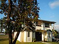 Municipal Library
 -
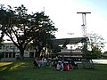 Town plaza and state or auditorium
 -
 Northern Luzon Adventist Hospital
 -
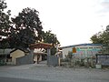 Artacho National High School


See also
References
- ^ "Municipalities". Quezon City, Philippines: Department of the Interior and Local Government. Retrieved 26 November 2012.
- ^ "Province: PANGASINAN". PSGC Interactive. Makati City, Philippines: National Statistical Coordination Board. Retrieved 26 November 2012.
- ^ a b c "Total Population by Province, City, Municipality and Barangay: as of May 1, 2010" (PDF). 2010 Census of Population and Housing. National Statistics Office. Retrieved 26 November 2012.
- ^ About Sison: Facts and Figures, Municipal Government of Sison, retrieved 2012
- ^ Official Website of Sison,Pangasinan
- ^ "2010 Census of Population and Housing: Population Counts - Cordillera Administrative Region" (PDF). National Statistics Office (Philippines), April 4, 2012. Retrieved 16 November 2014.
- ^ Official Website of Sison,Pangasinan
- ^ "Province of Pangasinan". Municipality Population Data. LWUA Research Division. Retrieved 9 September 2013.
- ^ "Sison, Pangasinan: Average Temperatures and Rainfall". World Weather Online. Retrieved 31 October 2015.
- ^ Local Government Code of the Philippines, Book III, Department of Interior and Local Government official website.
- ^ Official Website of Sison,Pangasinan
- ^ Official Website of Sison,Pangasinan
- ^ "PGMA unveils the marker of the newly-reconstructed Bued Bridge in Sison, Pangasinan". Balita. 21 June 2010. Retrieved 28 September 2014.
- ^ Morden, Johanna (21 June 2010). "Arroyo reopens major bridge in N. Luzon". Philippine Daily Inquirer. Retrieved 28 September 2014.
- ^ "Dioceses in the Philippines: Archdiocese of Lingayen-Dagupan". Claretian Publications. Retrieved 28 September 2014.
- ^ "Diocese of Urdaneta". Catholic Hierarchy. Retrieved 28 September 2014.
- ^ "Diocese of Urdaneta". CBCP Media Office. Catholic Bishops' Conference of the Philippines. Retrieved 28 September 2014.
- ^ "List of Parishes of the Roman Catholic Diocese of Urdaneta". Philippine Churches. 26 June 2012. Retrieved 28 September 2014.
- ^ "Shrine of Our Lady of Mt Carmel/ Our Lady of Mt Carmel Parish/ The Church of Sison (Sison, Pangasinan)". Pinoy Churches. 23 September 2012. Retrieved 28 September 2014.
- ^ "Our Lady of Mt. Carmel Parish". Wikimapia. Retrieved 28 September 2014.
External links
- Sison Official Website
- Philippine Standard Geographic Code
- Philippine Census Information
- Local Governance Performance Management System
Places adjacent to Sison, Pangasinan | |
|---|---|
| Municipalities |
|
|---|---|
| Component cities | |
| Independent component city |
|
| Barangays | |