Stånga
Stånga | |
|---|---|
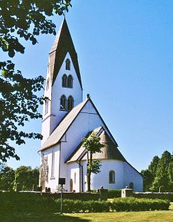
 Stånga Church | |
| Lua error in Module:Location_map at line 526: Unable to find the specified location map definition: "Module:Location map/data/Sweden Gotland modified" does not exist. | |
| Coordinates: 57°16′53″N 18°28′17″E / 57.28139°N 18.47139°E | |
| Country | Sweden |
| Province | Gotland |
| County | Gotland County |
| Municipality | Gotland Municipality |
| Area | |
| • Total | 1.05 km2 (0.41 sq mi) |
| Time zone | UTC+1 (CET) |
| • Summer (DST) | UTC+2 (CEST) |
Stånga is a locality on the Swedish island of Gotland, with 491 inhabitants in 2014.[2] Formerly a socken,[3] on 1 January 2016, it was reconstituted into the administrative area Stånga District.[4] It is most noted for hosting the annual Stånga Games.
Geography
Stånga is the name of the socken, now district. It is also the name of the larger locality within the district and the small village surrounding the medieval Stånga Church,[5] sometimes referred to as Stånga kyrkby. It is located in the southeast part of Gotland.[6]
One of the asteroids in the asteroid belt, 10131 Stånga, is named after this place.[7]
Stånga Games
The Stånga Games (Stångaspelen), also referred to as the "Gotland Olympic Games", is an annual sports competition in Stånga. The first games were concluded on 27 July 1924. The games are held during five days around the second weekend in July and gathers about 2000 participants. Competitions are held in various Gutnish disciplines, some dating back to the Viking Age.[8]
Sports
- Varpa
- Pärk
- Caber toss
- Gutnish pentathlon
- Pillow fight on a pole (Herre på stång)
- Leg hook (Rövkrok)
- Hobble kick (Sparka Bleistre)
- Tug of war, eight-man teams (Dragkamp)
- Two-men tug of war, facing (Att dra hank)
- Two-men tug of war, back to back (Att täme stäut)
References
- ^ "Tätorternas landareal, folkmängd och invånare per km2 2005 och 2010" (in Swedish). Statistics Sweden. 14 December 2011. Archived from the original on 10 January 2012. Retrieved 10 January 2012.
{{cite web}}: Unknown parameter|deadurl=ignored (|url-status=suggested) (help) - ^ a b "Gotland i siffror 2015". www.gotland.se. Gotland Municipality. Retrieved 25 May 2016.
{{cite web}}: Unknown parameter|trans_title=ignored (|trans-title=suggested) (help) - ^ The exact extent of the socken, now district, can be obtained by clicking on Kartinställningar and check the Socken box in the menu of this map from the Swedish National Heritage Board database.
- ^ "Förordning om district" (PDF). Ministry of Finance. 17 June 2015. Retrieved 25 May 2016.
{{cite web}}: Unknown parameter|trans_title=ignored (|trans-title=suggested) (help) - ^ Lagerlöf, Erland; Svahnström, Gunnar (1973). Gotlands kyrkor (in Swedish). Stockholm: Rabén & Sjögren. pp. 245–248. ISBN 91-29-41035-5. SELIBR 7232718.
{{cite book}}: Unknown parameter|trans_title=ignored (|trans-title=suggested) (help) - ^ "Stånga". www.ne.se. Nationalencyklopedin. Retrieved 31 May 2016.
- ^ "10131 Stanga (1993 FP73)". NASA. Retrieved 24 June 2016.
- ^ Molin, Maria (12 June 2015). "Stångaspelen för den oinvigde". www.gotland.net. Gotlands Media AB. Retrieved 24 June 2016.
{{cite web}}: Unknown parameter|trans_title=ignored (|trans-title=suggested) (help)
External links

