Suffolk Coastal
Appearance
Suffolk Coastal District | |
|---|---|
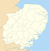
 Suffolk Coastal shown within Suffolk and England | |
| Sovereign state | United Kingdom |
| Constituent country | England |
| Region | East of England |
| Non-metropolitan county | Suffolk |
| Status | Non-metropolitan district |
| Admin HQ | Melton |
| Incorporated | 1 April 1974 |
| Government | |
| • Type | Non-metropolitan district council |
| • Body | Suffolk Coastal District Council |
| • Leadership | Leader & Cabinet ( ) |
| • MPs | Therese Coffey Dan Poulter |
| Area | |
| • Total | 344.2 sq mi (891.5 km2) |
| • Rank | (of 296) |
| Population (2022) | |
| • Rank | (of 296) |
| • Ethnicity | 98.1% White |
| Time zone | UTC0 (GMT) |
| • Summer (DST) | UTC+1 (BST) |
| ONS code | 42UG (ONS) E07000205 (GSS) |
| OS grid reference | TM2756349450 |
| Website | www |

Suffolk Coastal is a local government district in Suffolk, England. Its council is based in Melton, having moved from neighbouring Woodbridge in 2017. Other towns include Felixstowe, Framlingham, Leiston, Aldeburgh, and Saxmundham.
The district was formed on 1 April 1974, under the Local Government Act 1972, as a merger of the municipal borough of Aldeburgh, along with Felixstowe, Leiston-cum-Sizewell, Saxmundham and Woodbridge urban districts, and Blyth Rural District and Deben Rural District. The population of the district was 124,298 at the 2011 Census.[1]
Suffolk Coastal district will be merged with Waveney district on 1st April 2019 to form a new East Suffolk district.[2]
List of communities
There are 118 civil parishes and towns in Suffolk Coastal.
- Aldeburgh
- Alderton
- Aldringham cum Thorpe
- Badingham
- Bawdsey
- Benhall
- Blaxhall
- Blythburgh
- Boulge
- Boyton
- Bramfield
- Brandeston
- Bredfield
- Brightwell
- Bromeswell
- Bruisyard
- Bucklesham
- Burgh
- Butley
- Campsey Ash
- Capel St Andrew
- Charsfield
- Chediston
- Chillesford
- Clopton
- Cookley
- Cransford
- Cratfield
- Cretingham
- Culpho
- Dallinghoo
- Darsham
- Debach
- Dennington
- Dunwich
- Earl Soham
- Easton
- Eyke
- Falkenham
- Farnham
- Felixstowe
- Foxhall
- Framlingham
- Friston
- Gedgrave
- Great Bealings
- Great Glemham
- Grundisburgh
- Hacheston
- Hasketon
- Hemley
- Heveningham
- Hollesley
- Hoo
- Huntingfield
- Iken
- Kelsale cum Carlton
- Kesgrave
- Kettleburgh
- Kirton
- Knodishall
- Leiston
- Letheringham
- Levington
- Linstead Magna
- Linstead Parva
- Little Bealings
- Little Glemham
- Marlesford
- Martlesham
- Melton
- Middleton
- Monewden
- Nacton
- Newbourne
- Orford
- Otley
- Parham
- Peasenhall
- Pettistree
- Playford
- Purdis Farm
- Ramsholt
- Rendham
- Rendlesham
- Rushmere St Andrew
- Saxmundham
- Saxtead
- Shottisham
- Sibton
- Snape
- Sternfield
- Stratford St Andrew
- Stratton Hall
- Sudbourne
- Sutton
- Sutton Heath
- Swefling
- Swilland
- Theberton
- Thorington
- Trimley St Martin
- Trimley St Mary
- Tuddenham St Martin
- Tunstall
- Ubbeston
- Ufford
- Walberswick
- Waldringfield
- Walpole
- Wantisden
- Wenhaston with Mells Hamlet
- Westerfield
- Westleton
- Wickham Market
- Witnesham
- Woodbridge
- Yoxford
References
- ^ "District population 2011". Neighbourhood Statistics. Office for National Statistics. Retrieved 15 August 2016.
- ^ Ministry of Housing, Communities and Local Government (24 May 2018). "The East Suffolk (Local Government Changes) Order 2018". legislation.gov.uk. Retrieved 28 May 2018.

