
Tower City Center
Union Terminal Group | |
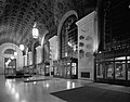
.jpg) View from Public Square | |
   | |
| Location | Cleveland, Ohio |
|---|---|
| Coordinates | 41°29′52″N 81°41′39″W / 41.49778°N 81.69417°W |
| Architect | Graham, Anderson, Probst & White; Walker & Weeks |
| Architectural style | Beaux-Arts, Art Deco |
| NRHP reference No. | 76001405[1] |
| Added to NRHP | March 17, 1976 |
Tower City Center, originally known as Cleveland Union Terminal, is a large mixed-use facility located on Public Square in downtown Cleveland, Ohio. The facility is composed of a number of interconnected office buildings, including the landmark Terminal Tower, the Avenue shopping mall, a casino, two hotels, and the main hub of Cleveland's four rapid transit lines. On March 17, 1976, the tower was added to the National Register of Historic Places as the Union Terminal Group.
History
The union terminal complex was originally commissioned by the Van Sweringen brothers, prominent local railroad moguls and real estate developers. The Vans were also responsible for the development of the upscale suburb of Shaker Heights. The complex was designed by the firm of Graham, Anderson, Probst, and White. Site preparation began in 1922, and approximately 2,200 buildings were demolished. Construction began in 1926, and structural work was completed by 1927. At the time, it was the second-largest excavation project in the world after the Panama Canal. The Terminal Tower opened to its first tenants in 1928. Three other office buildings, the Medical Arts Building, Builders Exchange Building, and Midland Building, were built in addition to the Terminal Tower. The three Art Deco buildings are collectively known as the Landmark Office Towers Complex and were completed in 1929. In addition to the new buildings, the 1918 Hotel Cleveland was connected to the complex. Cleveland Union Terminal was dedicated and officially opened in 1930.
The facility included a number of retail stores and restaurants. Original designs for the complex show that at first the brothers did not plan on building an office tower within the complex. However, they eventually decided to build the 52-story Terminal Tower on the northeast side of the complex facing Public Square.
From its completion until 1964, the Terminal Tower was the tallest building in North America outside of New York City.
In 1991, two new 11-story office towers, the Skylight Office Tower and the Chase Financial Plaza, were added. The Chase Building houses Cleveland's Ritz-Carlton Hotel and The Skylight Office Tower housed the former Hard Rock Cafe. After the completion of the nearby Gateway project in 1994, RTA built an indoor walkway connecting Tower City to the complex. A second walkway was built in 2002 to connect Tower City with the Carl B. Stokes U.S. Courthouse.
Higbee's (by then bought by Dillard's) closed its department store in the complex in January 2002. Positively Cleveland (formerly the Convention and Visitors Bureau of Greater Cleveland) and the Greater Cleveland Partnership (the local chamber of commerce) opened offices in the Higbee Building in 2007. Until late 2010, the Cleveland Plus Visitors Center occupied the first floor.[2][3][4] The building was opened on May 14, 2012 as the Horseshoe Casino Cleveland.[5] After Rock Gaming LLC took over management of the Horseshoe, the casino was transformed into Jack Cleveland Casino and reopened on May 11, 2016.[6]
In 2001, Time Warner Cable Amphitheater opened as an outdoor stage along the Cuyahoga River near the Tower City Complex. A site on the Cuyahoga River side of the complex was proposed as a location for a new Cleveland convention center, but in January 2009 the Cuyahoga County Commissioners decided to redevelop the existing facility.[7]
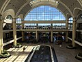
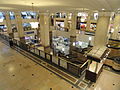
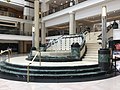
The Avenue
.jpg) The main concourse of Tower City Center | |
| Location | Cleveland, Ohio |
|---|---|
| Opening date | February 17, 1991 |
| Owner | Bedrock Real Estate Services (Dan Gilbert)[8] |
| No. of stores and services | 88[9] |
| No. of anchor tenants | 0 |
| Total retail floor area | 367,000 sq ft[9] |
| No. of floors | 3 |
| Website | www |
Most of the platform area was demolished in the late 1980s renovation of the building. The station area itself was converted by Forest City Enterprises into a mall and food court known as The Avenue, which opened in 1991. As part of the renovation, RTA rebuilt its rapid transit station beneath the center. The rest of the platform area was turned into a parking garage for the new complex. When the already renamed Tower City Center reopened, the mall housed many high-end retailers, including Bally of Switzerland, Barneys New York, Fendi, Gucci, Versace, and even had a letter of intent from Neiman Marcus to build a 120,000-square foot anchor store in 1992.[10][11][12] Over the following 25 years, many of those shops were replaced by more modest stores, some of them local retailers.[13]
Tower City Center is host to the annual Christmas "Toy Soldier Show": a Cleveland tradition starring the Toy Soldier (Robert Hruby) and the Fairy Godmother (Cathy Brenkus) which celebrated its 28th season in 2017.
-
-

-

-

-
 Tower City station
 -

-

-
-

-

-

-

-

-

-

-

-

.jpg)


.jpg)


.jpg)
.jpg)
.jpg)
.jpg)
.jpg)


.jpg)
Current RTA station
| Template:GCRTA Red/Blue/Green/Waterfront Line station | |||||||||||||||||||||||||||||||||||
 The westbound Red Line platform | |||||||||||||||||||||||||||||||||||
| General information | |||||||||||||||||||||||||||||||||||
| Location | 230 West Huron Road Cleveland, Ohio 44113 | ||||||||||||||||||||||||||||||||||
| Owned by | Greater Cleveland Regional Transit Authority | ||||||||||||||||||||||||||||||||||
| Platforms | 2 low island platforms for light rail 2 high island platforms for rapid transit | ||||||||||||||||||||||||||||||||||
| Tracks | 2 outer through tracks, 2 inner stub tracks, 2 non-revenue tracks | ||||||||||||||||||||||||||||||||||
| Connections | Lua error: expandTemplate: template "GCRTA color" does not exist. (Public Square/Tower City station) B Line Trolley E Line Trolley Other bus service at Public Square | ||||||||||||||||||||||||||||||||||
| Construction | |||||||||||||||||||||||||||||||||||
| Structure type | Underground | ||||||||||||||||||||||||||||||||||
| Parking | Paid parking only | ||||||||||||||||||||||||||||||||||
| Accessible | |||||||||||||||||||||||||||||||||||
| Other information | |||||||||||||||||||||||||||||||||||
| Website | Tower City Rapid Station | ||||||||||||||||||||||||||||||||||
| History | |||||||||||||||||||||||||||||||||||
| Opened | December 17, 1990 July 10, 1996 (Waterfront Line) | ||||||||||||||||||||||||||||||||||
| Services | |||||||||||||||||||||||||||||||||||
| |||||||||||||||||||||||||||||||||||
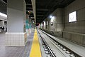
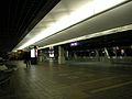
Tower City station, known alternatively as Tower City–Public Square and Tower City Center is a rapid transit station in Cleveland, Ohio, USA. It is the central station on the RTA Red Line and the major station on the RTA Green and Blue Lines. The station is located directly beneath Prospect Avenue in the middle of the Avenue shopping mall. The station is only accessible through the Tower City Center shopping complex, and, for this reason, the public concourse of the shopping mall is open at all times that the RTA Rapid Transit is in operation.
Located in downtown Cleveland, the station is the busiest RTA Rapid Transit station. It is also the only station to serve all of downtown Cleveland, in spite of the fact the Tower City complex is located on the south end of this district near the east shore of the Cuyahoga River; the rest of downtown is serviced by frequent bus service. It offers connections to all RTA buses serving Public Square. The station also includes a "Walkway to Gateway," which is a completely enclosed and air-conditioned skyway from Tower City Center to Quicken Loans Arena and Progressive Field of the Gateway Sports and Entertainment Complex, allowing RTA passengers, as well as those using the Tower City parking facilities, to walk to the arena or ballpark without having to go outside.
History
The Waterfront Line began service at Tower City on July 10, 1996.
On July 31, 2016, RTA began replacing the track bed for track 8, the main westbound track.[14] In order to prevent service disruptions during the track replacement, RTA temporarily reopened the Shaker rapid track to the public. Westbound trains arrived on that track and temporary platforms and station facilities were set up. The temporary station was not accessible from the main station entrance and had a separate entrance.[15] The new track opened to passengers on November 26, 2016.[16]
Station layout
Template:Tower City platform layout
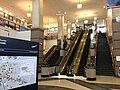
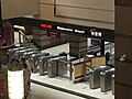
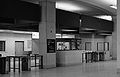
The station has two fare-collection entrances, one leading to a low platform station for use by the light rail Green and Blue Lines, and one leading to a high platform station for the heavy rail Red Line. Both entrances open from a lobby located on the lowest level of the Tower City shopping mall, and this lobby is accessible by escalators and elevators from the other levels of the mall. Each entrance has multiple fare gates along with two operator booths. The entrance for the Green and Blue Lines collects fares from passengers entering and leaving the station, since westbound passengers pay their fare upon leaving. The Red Line entrance collects fares from passengers entering the station and also requires arriving passengers to swipe their proof of payment card at the gate in order to exit the station.[17] In order to transfer from the Red Line to the Green or Blue Lines, or vice versa, passengers must exit through the fare gates at one station entrance and enter through the other station entrance. The high and low platform portions of the station could also be reached from each other without going through the lobby by an access ramp located along each side of tracks around the lobby; however, with the implementation of the proof of payment system on the Red Line, the ramps have been closed.
-

-
 Exit to Tower City Center
 -
 Station navigation
 -
 Elevator panel
 -
 Entrance to the Red Line platforms
 -
 Entrance to the Blue/Green/Waterfront Line platforms
 -
 Eastbound Blue/Green Line platforms
 -
 The westbound track in the Blue/Green Line section of the station in November 2016, about a week after renovations were completed
 -
 The Red Line platform in 2004
 -
 Main Station entrance before escalator renovations
.jpg)
.jpg)
.jpg)

.jpg)


Cleveland Union Terminal

The Cleveland Union Terminal was built by the Van Sweringen brothers as a terminal for all trains coming into Cleveland via the various railroad lines in a concept similar to Grand Central Terminal in New York City.[18]
History
When the Cleveland Union Terminal (CUT) was built in 1930 as part of the Terminal Tower complex, the train station allocated the northern set of tracks for interurban or rapid transit service and the southern set of tracks for inter-city rail service. The portion of the station above the interurban tracks was called the Traction Concourse and the portion above the intercity train tracks was called the Steam Concourse. The Van Sweringen brothers who developed Terminal Tower complex and built Cleveland Union Terminal[19] envisioned a network of interurban lines extending from the CUT in all directions. They even acquired right-of-way for some of the lines.
In 1931, the Higbee Company moved its main store to a new building connected to Cleveland Union Terminal. In 1934, the U.S. Postal Service moved its main Cleveland office to Union Terminal in a new building designed by the firm of Walker and Weeks. It was known as M.K. Ferguson Plaza under the ownership of Forest City Enterprises.[20]
The Union Terminal served most rail lines: the Baltimore and Ohio, New York Central and Nickel Plate Road.[21] Exceptions were the Pennsylvania Railroad and initially the Erie Railroad. It was never particularly popular with the railroads, however. It required deviating from the quicker route along Lake Erie. As the city would not allow trains to operate under steam power near the downtown area, trains were forced to switch from steam to electric power at a suburban rail yard when heading inbound and then reverse on the way out at another yard. As a result, some lines began to bypass the station entirely, heading along the lake route, and some trains stopped serving the city altogether. Several east-west routes by-passed the city to the south, passing through Akron or Youngstown. In addition, national passenger rail travel had already passed its peak and was starting its gradual decline in favor of the automobile and, later, the airplane. The Erie RR, owned by the Van Sweringens, could not afford the electric transfer and continued to use its own nearby station until 1948, when it replaced steam with diesel locomotives and was able to serve the Union Terminal under its own power.
Amtrak's short-lived Lake Shore served Union Terminal for seven months in 1971, but the railroad found the rents prohibitive. When the new Lake Shore Limited began in 1975 Amtrak chose to construct a new station near Lake Erie adjacent to the Cleveland Memorial Shoreway.[22] The new Amtrak station is located near the former Cleveland Union Station, once served by the Pennsylvania Railroad. The former Erie Railroad commuter service, ultimately inherited by Conrail, was discontinued on Jan. 14, 1977, ending the facility's use as a railroad station.[23]
| LS&MS (New York Central) - AMTK | ERIE (Erie Lackawanna Railway) - CR | CT&V (Baltimore and Ohio) - CVSR | |||||||||||||||||||||||||||||||||||||||||||||||||||||||||||||||||||||||||||||||||||||||||||||||||||||||||||||||||||||||||||||||||||||||||||||||||||||||||||||||||||||||||||||||||||||||||||||||||||||||||||||||||||||||||||||||||||||||||||||||||||||||||||||||||||||||||||||||||||||||||||||||||||||||||||||||||||||||||||||||||||||||||||||||||||||||||||||||||||||||||||||||||||||||||||||||||||||||||||||||||||||||||||||||||||||||||||||||||||||||||||||||||||||||||||||||||||||||||||||||||||||||||||||||||||||||||||||||||||||||||||||||||||||||||||||||||||||||||||||||||||||||||||||||||||||||||||||||||||||||||||||||||||||||||||||||||||||||||||||||||
|---|---|---|---|---|---|---|---|---|---|---|---|---|---|---|---|---|---|---|---|---|---|---|---|---|---|---|---|---|---|---|---|---|---|---|---|---|---|---|---|---|---|---|---|---|---|---|---|---|---|---|---|---|---|---|---|---|---|---|---|---|---|---|---|---|---|---|---|---|---|---|---|---|---|---|---|---|---|---|---|---|---|---|---|---|---|---|---|---|---|---|---|---|---|---|---|---|---|---|---|---|---|---|---|---|---|---|---|---|---|---|---|---|---|---|---|---|---|---|---|---|---|---|---|---|---|---|---|---|---|---|---|---|---|---|---|---|---|---|---|---|---|---|---|---|---|---|---|---|---|---|---|---|---|---|---|---|---|---|---|---|---|---|---|---|---|---|---|---|---|---|---|---|---|---|---|---|---|---|---|---|---|---|---|---|---|---|---|---|---|---|---|---|---|---|---|---|---|---|---|---|---|---|---|---|---|---|---|---|---|---|---|---|---|---|---|---|---|---|---|---|---|---|---|---|---|---|---|---|---|---|---|---|---|---|---|---|---|---|---|---|---|---|---|---|---|---|---|---|---|---|---|---|---|---|---|---|---|---|---|---|---|---|---|---|---|---|---|---|---|---|---|---|---|---|---|---|---|---|---|---|---|---|---|---|---|---|---|---|---|---|---|---|---|---|---|---|---|---|---|---|---|---|---|---|---|---|---|---|---|---|---|---|---|---|---|---|---|---|---|---|---|---|---|---|---|---|---|---|---|---|---|---|---|---|---|---|---|---|---|---|---|---|---|---|---|---|---|---|---|---|---|---|---|---|---|---|---|---|---|---|---|---|---|---|---|---|---|---|---|---|---|---|---|---|---|---|---|---|---|---|---|---|---|---|---|---|---|---|---|---|---|---|---|---|---|---|---|---|---|---|---|---|---|---|---|---|---|---|---|---|---|---|---|---|---|---|---|---|---|---|---|---|---|---|---|---|---|---|---|---|---|---|---|---|---|---|---|---|---|---|---|---|---|---|---|---|---|---|---|---|---|---|---|---|---|---|---|---|---|---|---|---|---|---|---|---|---|---|---|---|---|---|---|---|---|---|---|---|---|---|---|---|---|---|---|---|---|---|---|---|---|---|---|---|---|---|---|---|---|---|---|---|---|---|---|---|---|---|---|---|---|---|---|---|---|---|---|---|---|---|---|---|---|---|---|---|---|---|---|---|---|---|---|---|---|---|---|---|---|---|---|---|---|---|---|---|---|---|---|---|---|---|---|---|---|---|---|---|---|---|---|---|---|---|---|---|---|---|---|---|---|---|---|---|---|---|---|---|---|---|---|---|---|---|---|---|---|---|---|---|---|---|---|---|---|---|---|---|---|---|---|---|---|---|---|---|---|---|---|---|---|---|---|---|---|---|---|---|---|---|---|---|---|---|---|---|---|---|---|---|---|---|---|---|---|---|---|---|---|---|---|---|---|
|
|
| |||||||||||||||||||||||||||||||||||||||||||||||||||||||||||||||||||||||||||||||||||||||||||||||||||||||||||||||||||||||||||||||||||||||||||||||||||||||||||||||||||||||||||||||||||||||||||||||||||||||||||||||||||||||||||||||||||||||||||||||||||||||||||||||||||||||||||||||||||||||||||||||||||||||||||||||||||||||||||||||||||||||||||||||||||||||||||||||||||||||||||||||||||||||||||||||||||||||||||||||||||||||||||||||||||||||||||||||||||||||||||||||||||||||||||||||||||||||||||||||||||||||||||||||||||||||||||||||||||||||||||||||||||||||||||||||||||||||||||||||||||||||||||||||||||||||||||||||||||||||||||||||||||||||||||||||||||||||||||||||||
-
-

-

-
 Former departure board
 -
 Platforms converted into parking decks


.jpg)

Former Red Line station
 Red line platforms | |||||||||||||||||||||||||||||||||||||||
| General information | |||||||||||||||||||||||||||||||||||||||
| Owned by | Greater Cleveland Regional Transit Authority | ||||||||||||||||||||||||||||||||||||||
| Construction | |||||||||||||||||||||||||||||||||||||||
| Structure type | Underground | ||||||||||||||||||||||||||||||||||||||
| History | |||||||||||||||||||||||||||||||||||||||
| Opened | March 15, 1955 | ||||||||||||||||||||||||||||||||||||||
| Closed | 1980s-1990s | ||||||||||||||||||||||||||||||||||||||
| Previous names | Public Square, Cleveland Terminal | ||||||||||||||||||||||||||||||||||||||
| Original company | Cleveland Transit System | ||||||||||||||||||||||||||||||||||||||
| Key dates | |||||||||||||||||||||||||||||||||||||||
| Interurban platforms built | July 20, 1930 | ||||||||||||||||||||||||||||||||||||||
| Platforms rebuilt | 1955 | ||||||||||||||||||||||||||||||||||||||
| |||||||||||||||||||||||||||||||||||||||
The Red Line took the place of a never-built interurban line. An additional vault for that line was located at Mayfield Road, now the Little Italy–University Circle station.
History
The Shaker rapid transit remained the only service using the interurban portion of the CUT for 25 years. When the Cleveland Transit System built its rapid transit (later designated the Red Line) in 1955 (using much of the right-of-way previously developed by the Van Sweringens), another rapid transit station was built in the former interurban area of the CUT to serve it. Since the CTS Rapid Transit (Red Line) and the Shaker rapid transit (Green and Blue Lines) were owned by different entities at the time, there was no fare transfer between the trains, and the stations were entirely separate.
In 1968, the Cleveland Transit System line finished its extension through Cleveland's west side to Cleveland Hopkins International Airport and Cleveland became the first North American city with direct rapid transit access from downtown to an airport.[24]
Both lines became part of the Greater Cleveland Regional Transit Authority when it assumed control on September 5, 1975. The two stations remained separate until December 17, 1990, when a completely new station was completed with the development of Tower City Center.[25]
-
 Main Red Line entrance in 1980s
 -
 Secondary Red Line entrance in 1980s
 -
 Red Line platform in 1980s looking east
 -
 End of platform
 -
 The entrance to the CTS station in 1968


Former Shaker Rapid station
 Shaker train platform | ||||||||||||||||||||||||||||||||||||||||||||||||||||||||||||||||||||||||||||||||||||||
| General information | ||||||||||||||||||||||||||||||||||||||||||||||||||||||||||||||||||||||||||||||||||||||
| Owned by | Greater Cleveland Regional Transit Authority | |||||||||||||||||||||||||||||||||||||||||||||||||||||||||||||||||||||||||||||||||||||
| Line(s) | C.I.R.R. Main line | |||||||||||||||||||||||||||||||||||||||||||||||||||||||||||||||||||||||||||||||||||||
| Construction | ||||||||||||||||||||||||||||||||||||||||||||||||||||||||||||||||||||||||||||||||||||||
| Structure type | Underground | |||||||||||||||||||||||||||||||||||||||||||||||||||||||||||||||||||||||||||||||||||||
| History | ||||||||||||||||||||||||||||||||||||||||||||||||||||||||||||||||||||||||||||||||||||||
| Opened | July 20, 1930 July 31, 2016 | |||||||||||||||||||||||||||||||||||||||||||||||||||||||||||||||||||||||||||||||||||||
| Closed | 1980s-1990s November 26, 2016 | |||||||||||||||||||||||||||||||||||||||||||||||||||||||||||||||||||||||||||||||||||||
| Previous names | Public Square, Downtown Terminal, Cleveland Terminal | |||||||||||||||||||||||||||||||||||||||||||||||||||||||||||||||||||||||||||||||||||||
| Original company | Cleveland Interurban Railroad | |||||||||||||||||||||||||||||||||||||||||||||||||||||||||||||||||||||||||||||||||||||
| ||||||||||||||||||||||||||||||||||||||||||||||||||||||||||||||||||||||||||||||||||||||
These platforms opened with the extension of the Cleveland Interurban Railroad from East 55th Street in 1930.
History
Since the Van Sweringens owned Cleveland Interurban Railroad which served the suburb of Shaker Heights, the interurban portion of the CUT was immediately occupied by the Shaker trains upon completion on July 20, 1930. (Previously, the Shaker trains had used streetcar tracks to reach downtown from East 34th Street, which caused significantly slower service.) The Shaker rapid transit station was located along the northern-most tracks of the complex, and it included a small yard for the storage of a few trains and a loop to allow trains to reverse direction. Development of the other interurban services, however, was stalled by the Great Depression, which hit the Van Sweringens particularly hard. By 1944, ownership of the Shaker rapid transit passed to the city of Shaker Heights.
The Shaker and Van Aken lines became part of the Greater Cleveland Regional Transit Authority when it assumed control on September 5, 1975. The two stations remained separate until December 17, 1990, when a completely new station was completed with the development of Tower City Center.[26]
The platform was temporarily re-opened for westbound passengers in 2016.
| Tower City station track layout[27] | |||||||||||||||||||||||||||||||||||||||||||||||||||||||||||||||||||||||||||||||||||||||||||||||||||||||||||||||||||||||||||||||||||||||||||||||||||||||||||||||||||||||||||||||||||||||||||||||||||||||||||||||||||||||||||||||||||||||||
|---|---|---|---|---|---|---|---|---|---|---|---|---|---|---|---|---|---|---|---|---|---|---|---|---|---|---|---|---|---|---|---|---|---|---|---|---|---|---|---|---|---|---|---|---|---|---|---|---|---|---|---|---|---|---|---|---|---|---|---|---|---|---|---|---|---|---|---|---|---|---|---|---|---|---|---|---|---|---|---|---|---|---|---|---|---|---|---|---|---|---|---|---|---|---|---|---|---|---|---|---|---|---|---|---|---|---|---|---|---|---|---|---|---|---|---|---|---|---|---|---|---|---|---|---|---|---|---|---|---|---|---|---|---|---|---|---|---|---|---|---|---|---|---|---|---|---|---|---|---|---|---|---|---|---|---|---|---|---|---|---|---|---|---|---|---|---|---|---|---|---|---|---|---|---|---|---|---|---|---|---|---|---|---|---|---|---|---|---|---|---|---|---|---|---|---|---|---|---|---|---|---|---|---|---|---|---|---|---|---|---|---|---|---|---|---|---|---|---|---|---|---|---|---|---|---|---|---|---|---|---|---|---|---|
|
| ||||||||||||||||||||||||||||||||||||||||||||||||||||||||||||||||||||||||||||||||||||||||||||||||||||||||||||||||||||||||||||||||||||||||||||||||||||||||||||||||||||||||||||||||||||||||||||||||||||||||||||||||||||||||||||||||||||||||

See also
- Public Square
- Downtown Cleveland
- Key Tower
- 200 Public Square
- List of Registered Historic Places in Cleveland, Ohio
Connected components of Tower City Center
- Chase Financial Plaza
- Jack Cleveland Casino
- Renaissance Cleveland Hotel
- Skylight Office Tower
- Terminal Tower
Walkway connections
Additional buildings
- Landmark Office Towers Complex
- Post Office Plaza / M.K. Ferguson Plaza (connected by private elevators in the parking garage)
References
- ^ "National Register Information System". National Register of Historic Places. National Park Service. April 15, 2008.
- ^ "About Cleveland". Positively Cleveland. Retrieved June 10, 2008.
- ^ Litt, Steven (February 3, 2011). "Casino won't dramatically alter Cleveland's beloved Higbee Building". Cleveland.com. Advance Publications. Retrieved May 11, 2016.
- ^ "Something's Happening Here" (PDF). Zygote Press. p. 34. Retrieved May 11, 2016.
{{cite web}}: templatestyles stripmarker in|work=at position 1 (help) - ^ http://blog.cleveland.com/metro/2011/07/horseshoe_casino_cleveland_des.html
- ^ TEGNA. "New name, new vibe for Cleveland Jack casino". WKYC. Retrieved 2016-06-02.
- ^ Litt, Steven (January 31, 2009). "Chosen medical mart site offers second chance for Mall". Cleveland.com. Advance Publications. Retrieved February 20, 2009.
- ^ Jarboe, Michelle (March 23, 2016). "Dan Gilbert buys the Avenue shopping mall at Tower City in downtown Cleveland". Cleveland.com. Advance Publications. Retrieved March 24, 2016.
- ^ a b "The Avenue at Tower City Center". Forest City Enterprises. Retrieved September 29, 2010.
- ^ Jarboe, Michelle (March 21, 2009). "Cleveland's downtown is considered choice real estate for outlet shopping". Cleveland.com. Advance Publications. Retrieved March 24, 2016.
- ^ Turbett, Peggy (March 25, 2012). "Forest City CEO David LaRue oversees change at company, Tower City Center: Talk with the Boss". Cleveland.com. Advance Publications. Retrieved March 23, 2013.
- ^ "Cleveland Bucking The Gloomy Trend In Malls". Chicago Tribune. Tribune Publishing. February 17, 1991. Retrieved March 23, 2013.
- ^ "Tower City then and now". Cleveland.com. Advance Publications. October 14, 2007. Retrieved June 15, 2008.
- ^ Christ, Ginger (2016-07-29). "Westbound RTA passengers to use new Tower City entrance starting Sunday". The Plain Dealer. Retrieved 2016-08-05.
- ^ Christ, Ginger (2016-08-01). "RTA passengers begin using new Tower City entrance". The Plain Dealer. Retrieved 2016-08-05.
- ^ "Rail Riders - Track 8 Returns to Full Service". Greater Cleveland Regional Transit Authority. 2016-11-26. Retrieved 2016-12-04.
- ^ "Red Line upgrades fare collection system" (Press release). Greater Cleveland Regional Transit Authority. 2009-08-05. Retrieved 2009-08-10.
- ^ "Shaker Hts. & The Van Sweringens". Cleveland Historical. Retrieved May 11, 2016.
{{cite web}}: templatestyles stripmarker in|work=at position 1 (help) - ^ Van Tassel, David D.; Grabowski, John J., eds. (1996). "Cleveland Union Terminal". The Encyclopedia of Cleveland History (2nd ed.). Bloomington: Indiana University Press. ISBN 0-253-33056-4. Retrieved 2007-01-01.
- ^ "Post Office Plaza". Forest City Enterprises. Retrieved September 29, 2010.
- ^ McGraw-Hill 1918, p. 865.
- ^ Toman and Hayes 1996, pp. 280 and 295.
- ^ Toman and Hayes 1996, p. 297.
- ^ "History of public transit in Greater Cleveland". Greater Cleveland Regional Transit Authority. Retrieved May 11, 2016.
- ^ "About RTA:History of Public Transit in Greater Cleveland". RTA Website. Retrieved 2007-06-26.
- ^ "About RTA: History of Public Transit in Greater Cleveland". RTA Website. Retrieved 2007-06-26.
- ^ Toman, James (1990). The Shaker Heights Rapid Transit. Glendale, California: Interurban Press. ISBN 0916374955.
Sources
- Herrick, Clay (1987). Cleveland Landmarks. Cleveland: Cleveland Restoration Society. ASIN B000KCXJSS.
- Johannesen, Eric (1979). Cleveland Architecture 1876-1976 (Digital edition–2007). Ann Arbor, Michigan (Cleveland–Digital): University of Michigan (Western Reserve Historical Society–Digital). ISBN 978-0911704211.
- Rarick, Holly (1986). Progressive Vision: The Planning of Downtown Cleveland 1903-1930. Mishawaka, Indiana: Better World Books. ISBN 978-0910386869.
- Van Tassel, David; Grabowski, John (1987). The Encyclopedia of Cleveland History, 2nd edition (1996). Bloomington, Indiana: Indiana University Press. ISBN 978-0253330567.
- Toman, Jim; Hayes, Blaine S. (1996). Horse trails to regional rails: the story of public transit in greater Cleveland. Kent, Ohio: Kent State University Press. pp. 280, 295, and 297. ISBN 978-0873385473.
- Electric Railway Journal, 1918, Volume 51 (Classic Reprint) Paperback – September 27, 2015. New York City (Leicestershire): McGraw-Hill Publishing (Forgotten Books). 1918. p. 895. ISBN 978-1330512098.
External links
- Cleveland Union Terminal Collection
- Official website
- Cleveland FalconCam
- RTA website
- Photos of Tower City Station from Subway Nut
- Database of railroad stations in Cuyahoga County
Template:NYC stations: Elyria–Cleveland Template:NYC stations: Cleveland–Painesville
| Topics | |
|---|---|
| Lists by state |
|
| Lists by insular areas | |
| Lists by associated state | |
| Other areas | |
| Related | |
- Tower City Center
- 1930 establishments in Ohio
- Art Deco architecture in Ohio
- Beaux-Arts architecture in Ohio
- Buildings and structures in Cleveland
- Former Amtrak stations in Ohio
- Forest City Enterprises
- Hotels in Cleveland
- National Register of Historic Places in Cleveland, Ohio
- Red Line (RTA Rapid Transit)
- Blue Line (RTA Rapid Transit)
- Green Line (RTA Rapid Transit)
- Waterfront Line (RTA Rapid Transit)
- Railway stations opened in 1930
- Railway stations located underground in the United States
- Shopping malls established in 1991
- Shopping malls in Cuyahoga County, Ohio
- Former Baltimore and Ohio Railroad stations
- Former New York Central Railroad stations
- Former Erie Railroad stations
- Former New York, Chicago and St. Louis Railroad stations
- Tourist attractions in Cleveland
- Union stations in the United States