
Uxbridge, Massachusetts
Uxbridge | |
|---|---|
 Taft Brothers Block, Downtown Uxbridge | |
 Flag | |
| Nickname(s): "Home of America's First Legal Woman Voter" and "Geographic Center of the Blackstone River Valley National Heritage Corridor" | |
 Location in Worcester County in Massachusetts | |
| Country | United States |
| State | Massachusetts |
| County | Worcester |
| Settled | 1662 |
| Incorporated | 1727 |
| Government | |
| • Type | Representative town meeting |
| • Chairman, Board of Selectmen | Michael Potaski |
| • Vice Chairman, Board of Selectmen | Kevin Kuros |
| • Clerk, Board of Selectmen | Beth A. Pitman |
| • Selectmen | Carrie Kay Robertson, Peter Baghdasarian |
| • Town Manager | Michael A Szlosek |
| Area | |
| • Total | 30.4 sq mi (78.7 km2) |
| • Land | 29.5 sq mi (76.5 km2) |
| • Water | 0.8 sq mi (2.1 km2) |
| Elevation | 270 ft (82 m) |
| Population (2000) | |
| • Total | 11,156 |
| • Density | 377.6/sq mi (145.8/km2) |
| Time zone | UTC-5 (Eastern) |
| • Summer (DST) | UTC-4 (Eastern) |
| ZIP code | 01569, 01538, 01525 |
| Area code | 508 / 774 |
| FIPS code | 25-71620 |
| GNIS feature ID | 0618387 |
| Website | http://www.uxbridge-ma.gov/ |


Uxbridge is a suburban New England town in Worcester County, Massachusetts, in the United States. First "officially" settled by Europeans in 1662, it was later incorporated in 1727 at Suffolk County, Province of Massachusetts Bay, and named for England's Earl of Uxbridge. The town was split off from Mendon and located at two former Praying "Nipmuck" Indian villages, at Rice City and at Wacentug, ("walk-in-tuck"). It's part of Greater Boston, and the Worcester metropolitan statistical area, in the nation's fifth largest Combined Statistical Area. It is located 16 miles (26 km) SSE of Worcester, 20.4 miles (32.8 km) NNW of Providence, Rhode Island, 34 miles (55 km) SW of Boston, and 8.7 miles (14.0 km) WSW of Interstate 495. The 2009 estimated population is 13,247.[1] The census of 2000 reported 11,156 people.
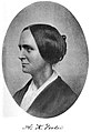
Uxbridge spanned the colonial era, the American Revolution and the industrial revolution, having been noted for early textiles, and women's rights. Among its first settlers was the Taft family from England. Today it is the geographic center of the Blackstone River Valley National Heritage Corridor, the oldest industrialized region in the U.S. There are over 375 state or national historic sites here, with an excellent variety of architectural styles, and well preserved remnants of the Blackstone Canal. Cashmere woolens, and military uniforms were manufactured here for over 100 years in several large mills. The first Unted States Air Force Dress Uniform, dubbed "Uxbridge Blue", was made here. Notable women included: 1) America's first legal woman voter, Lydia Chapin Taft,[2] a Revolutionary war soldier, Deborah Sampson, 3) fiery abolitionist Abby Kelley Foster, 4) Olympic Medalist, Alice Bridges, and 5) film art producer, Jeannine Oppewall. Baxter Hall, an 18 year old drummer, helped "muster" America's first battle for freedom at the Lexington Alarm. Colonel Seth Reed from Uxbridge, fought at Bunker Hill, and was apparently "instrumental", in placing E Pluribus Unum, on U.S. Coins.
History
Colonial era, Quakers, Revolution
-

-
 Nipmuck dancers today in the Blackstone Valley
 -
Puritan Missionary, John Eliot, started 14 Praying Indian Villages such as those at RIce City and Wacentug and was a witness for the original deed with native Americans of what became the original town (Mendon).
-
 Cornet John C. Farnum, Jr. House, 1710, houses Uxbridge Historical Society
 -
 Nathan Webb's Church (1731), first new Congregational Church in Massachusetts, First Great Awakening Period
 -
 Friends Meeting House (1770), Quaker Highway at Route 98, Uxbridge, MA. Abolitionist Quakers with ties to Moses Brown first resettled here from Rhode Island.
 -
-
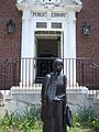 Statue of Deborah Sampson at Sharon, Massachusetts public library, She served in the Revolution as "Robert Shurtlieff of Uxbridge"
 -
 Lt. Simeon Wheelock House (1768), Deborah Wheelock Chapter, D.A.R. Lt. Wheelock died in Shay's rebellion while on duty protecting the Springfield Armory. Shay's Rebellion had opening salvos in Uxbridge.
 -

-
 Captain Baxter Hall was a drummer in the first musters of the Revolutionary War. He responded to the Lexington Alarm at age 18 and drummed the first drum beats of American freedom. The uniforms of the period resembled this photo.


Native American people known as the Nipmuck inhabited early Uxbridge.[3][4][5] Puritan Missionary John Eliot helped start Praying Indian villages such as Wacentug, and Rice City, from circa 1640. Praying Indians sold land to early settlers in 1662,[6] "for 24 pound Ster", witnessed by John Eliot.[6][6][7] King Phillips War burned the original town of Mendham, and the community was resettled in 1680. Western Mendon incorporated as Uxbridge in June 1727, and Farnum House held the first town meeting.[8] One of the first official acts at the next annual Town Meeting, was to appropriate fifteen gallons of 'ye good rum for ye raising of ye meeting house'. Reverend Nathan Webb's church, the first church in Uxbridge, was the Colony's first new Congregational church in the Great Awakening period.[9] Lydia Chapin Taft, voted to fund the French and Indian war in 1756, a first step for women's suffrage, legislated by the Uxbridge Town Meeting.[2] In 1769, Smithfield, Rhode Island Quakers settled here. They were among the earliest Quakers to resettle in Massachusetts following an expulsion of Quakers by Puritans in the 17th century. Quakers built mills, railroads, houses, tools and Conestoga wagon wheels.[10][11][12] Southwick's store housed Uxbridge's "Social and Instructive Library", established in 1775. Friends Meetinghouse, built on Moses Farnum's farm, with bricks made from a local brickyard,[13] claimed "fiery abolitionist" Abby Kelley Foster.[14][15][16] Benedict Arnold's widow, Peggy Shippen, a Philadelphia heiress and a Quaker, settled in Uxbridge before she died in 1836.[17] Seth and Joseph Read joined local Committees of Correspondence by July of 1774.[18] Captain Baxter Hall was a Lexington and Bunker Hill drummer. Lt. Col. Seth Read fought at Bunker Hill, and in the Invasion of Canada (1775), under Colonel John Paterson. Washington stopped at Col. Reed's Uxbridge tavern, on his way to assume command of the Continental Army.[17][19] Baxter Hall, was a Lexington and Bunker Hill drummer.[20] Samuel Spring, was a Revolutionary war chaplain.[21] Deborah Sampson, America's first woman soldier, enlisted in the Continental Army at Bellingham as "Robert Shurtlieff of Uxbridge".[22] Shays' Rebellion, considered the last battle of the Revolution, had its opening salvos in Uxbridge on Feb. 3, 1783.[23][24] Gov. John Hancock suppressed local riots, after a request by Colonel Nathan Tyler of Uxbridge.[23][24] Lieutenant Simeon Wheelock, died at Springfield when he was killed by a horse.[10] Shays' Rebellion caused George Washington to advocate a stronger national government.[25] In March of 1786, Seth Reed petitioned both houses of the legislature, to mint Massachusetts coins, and somehow became instrumental in adding E pluribus unum ("Out of Many, One,") to U.S. coins.[18][26][27] In 1789, new President Washington, made his first overnight stop in Uxbridge on his Inaugural tour of New England.[28][29]
Early transportation, education and public health
Robert Taft I and his sons built the first bridge across the Blackstone River in 1709. The Middle Post Road,[30] meandered past rocky Yankee farms and woods, from east to west. When production from the mills began, "teamsters" drove huge wagons, pulled by "teams" of horses, on the main stage route from Worcester to Providence. The Blackstone Canal, 1828, became the second U.S. barge canal, following the Erie Canal in upstate New York.[6][31][32] The canal boat trip from Worcester to Providence, took two days, and Uxbridge was the overnight stopping point. Construction of the Blackstone Canal may have been potentially motivated by competition, and a desire to curtail "Water rights" of rival enterprising industrialists.[33] The Providence and Worcester Railroad was completed in 1847 and the canal ceased operations in 1848.
On December 10, 1818, a small group of 16 men got together and met at Spring’s Hall Tavern in North Uxbridge, which was located at the north end of Rivulet St. Each of these men professed a true faith in a higher being and gathered in brotherhood, and called to order the first meeting of Solomon’s Temple Lodge of Ancient Free & Accepted Masons. Masonry was already a solid establishment in Massachusetts, having previously receiving a charter from the Grand Lodge of England in 1733. The first meeting was held on that very day and meetings continue to this day. As the records of the lodge indicate, the first order of business was to find a meeting place that they could call their own. On June 3, 1819, the brethren voted to erect it’s own hall noting that the area North of the town common would be a suitable place. In conjunction with the town, the building was raised with the second floor being used for Masonic purposes and the first floor being used as a private schoolhouse. This building would be known as the “Academy Building.” The Lodge was the first to make use of the building with 29 members present on November 25, 1819. The Lodge has met in this very building ever since, a record purported to be unmatched by any other Masonic Lodge in Massachusetts. Abiding by its vows to charity, the Lodge allowed the hall to be used by several religious and fraternal organizations, including the First Congregational Society in 1835, The Uxbridge Lodge of Odd Fellows in 1847, the Sons of Temperance in 1860, Court Purity in 1891, and Rathbobone Lodge, Knights of Pythias in 1898. Thus began a long line of charitable works performed by the Lodge that passed down through the years.
Uxbridge built its first grammar school in 1788, and in 1797 established 13 District schools, as one room school houses. The Uxbridge Academy became a sought after New England Prep School until 1851.
Uxbridge voted against smallpox vaccine in 1775,[2] published vital records through 1850,[17] and recorded "Benedict Anrold's widow's" death in 1836.[17] Infant mortality was high,[17] and infection related deaths included "Quincy", smallpox, "dysentary", and tuberculosis.[10][17] An 1896 Uxbridge malaria outbreak prompted health officer, Dr. Leonard White, to write a report to the State Board of Health, which led to study of mosquito-malaria links, and the first efforts for malaria prevention. State pathologist Theobald Smith, asked that White's son collect mosquito specimens for further analysis, and that citizens 1) add screens to windows, and 2) drain collections of water.[34] Water pollution from industrialization eventually became a problem for local rivers and municipal wells.
Industrial era photos
-
 Mill worker housing, Ironstone Cotton Manufacturing Company, built 1814
 -
 Crown & Eagle Mill, built in 1824 by Robert Rogerson, who like Samuel Slater, immigrated from England with industrial plans, is considered a masterpiece of early American Industrial architecture
 -
 Canoes on the Blackstone Canal. The Blackstone Canal was built starting in 1824 and provided early freight transport by horse pulled barges from Providence to Worcester.
 -
 Stanely Woolen Mill, built by Moses Taft, with view of the Blackstone Canal, was the scene for two movies, The Great Gatsby, 1974, and Oliver's Story, 1978. In 1989, it had been the longest continuously operating family-owned mill in the US. This mill ran 24/7 making Civil War blue woolen cloth for military uniforms.
 -
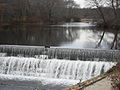 Mumford River's Capron Falls. Water powered early Uxbridge mills
 -
 The Capron mill, built by John Capron Sr. and his sons Effingham, and John, circa 1820 manufactured the first satinets, used the first power looms for woolens in America, and made US military uniforms for over 140 years, including the first US Air Force dress uniform, "Uxbridge 1683", aka Uxbridge Blue.
 -
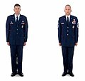 Current US Air Force Service Dress uniforms similar to Uxbridge Blue, made here in 1947: Officer on the left, enlisted on the right. Taken from AFI 36-2903
 -
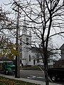 Unitarian Church at Uxbridge where Judge Henry Chapin delivered a historical address in 1864, and was an amateur historian of this community. Henry Chapin was a prominent Unitarian Church leader in Massachusetts. The Unitarian Church was prominent in the Industrial period of this community.


Industrial era: 19th century to mid-20th century
Large scale industrial development began at Uxbridge as early as 1775.[35] Richard Mowry, an Uxbridge farmer, built and marketed equipment to manufacture woolen, linen or cotton cloth, around the time of the Revolution.[36] Uxbridge, an early mill town, had industries, gristmills, sawmills, three or more forges, bog iron ore, distilleries, and more than 20 local textile mills.[3][10] In 1855, 560 local workers made 2.5 million yards of cloth.[3][10][35] Entrepreneurs here innovated the first power looms for woolens, satinets, wool-nylon serge, and other wool synthetic blends, 'wash and wear' fabrics, and latch hook yarn kits. Nearly every section of town had its own mill village, complete with mills, shops, housing, farms, and baseball leagues. William Arnold's 1815 Ironstone cotton mill, later made Kentucky Blue Jeans.[10] Seth Reed's 1777 gristmill became a gun factory in the 1880s. Power looms for woolens made the first cashmere satinets in America, in 1820.[3][6][35][37] Hecla had Daniel Day's 1810 woolen mill,[2][6] and Hilena Lowell's shoe factory. Calumet's (Central Woolen) ran 24/7 making Civil War cloth.[10] Woolen Mills, such as 'Central Woolen', represented a complete vertical integration of the business.[33] North Uxbridge was home to Clapp's 1810 Cotton Mill, Blanchard's granite quarry, and Rogerson's village. Robert Rogerson's Crown and Eagle Cotton Mill, is considered a masterpiece of early industrial architecture. Capron's Mill grew into a large textile complex, the Bachman Uxbridge Worsted Company, with thirteen plants nationwide in four states with over 6,000 workers and manufactured military uniforms and clothing, and reached the top in the women's fashion industry. Civil War, World War I, World War II Army and nurse corps uniforms, the first Air Force 'dress uniform', "Uxbridge 1683 Blue",[10][38] and "latch hook kits" were made here.
Mid-20th century to present


The late 20th century was marked by state and national parks developed around historic mills. Large mill fires signaled the end of local textiles which had declined since the Great Depression. Production from local mills ended, rivers were restored,[39] and community renewal followed. The Great Gatsby (1974) and Oliver's Story (1978) were filmed locally including Stanley Woolen Mill. The National Heritage Corridor[40] contains the 1,000-acre (4.0 km2) Blackstone Canal Heritage State Park,[41] 9 miles (14 km) of the Blackstone River Bikeway,[42] the Southern New England Trunkline Trail, and West Hill Dam Army Corps wildlife refuge.[43] 60 Federalist homes[10] add to 54 National, and 375 state-listed historic sites, including Georgian Elmshade, and other historic architectural styles.[10] See National historic sites
A 2007 fire of epic proportions[citation needed] destroyed the 400,000-square-foot (37,000 m2) Bernat Mill, 500 jobs, and 65 businesses.[44] The ten-alarm fire quickly overwhelmed local resources, requiring a fire-fighting response from two states and 66 local fire departments. The original historic wooden mill of John and Effingham Capron was preserved by extraordinary fire fighting, incident command and execution. The local economy was severely affected. The Fire Marshal traced the fire to a welding company and failed sprinklers. Stanley Woolen Mill is currently being restored for commercial uses. Waucantuck Mill, a national historic site, was razed for condominium and retail construction, due to toxic wastes.
Notable families and people
.jpg)

Immigrants, like Robert Taft I, who settled here in 1680, had descendants who became national leaders. Taft's grandson's widow, Lydia Chapin Taft, was "America's first woman voter", in October of 1756.[2] Samuel Taft hosted George Washington's inaugural tour in 1789 in his home, which later hosted a second Presidential visit in 1910.[2] Ezra Taft Benson was an Apostle of the LDS Church from 1846–1867, and Utah legislator. His great grandson, also named Ezra Taft Benson, was the U.S. Secretary of Agriculture and LDS Church President. Peter Rawson Taft I's son, Secretary of War Alphonso Taft (1874) delivered an impassioned speech in Uxbridge on his family's history at a famous 1874 family reunion at Elmshade.[45] Young William Howard Taft, Alfonso's son, and William's brother Charles Phelps Taft (who founded the Chicago Cubs) both likely heard it. Peter's grandson, U.S. President William Howard Taft, visited Samuel Taft House in 1910 on an official state visit with Governor Eben Draper.[46] Benedict Arnold's widow, Peggy Shippen, who was a Quaker, may have died here February 14, 1836 as "Sarah Arnold, widow of Benedict", at age 83.[47] A local immigrant boy, Arthur MacArthur, Sr. became Governor, Lt. Governor and Supreme Court Justice in Wisconsin and Washington, D.C. Arthur's grandson, Douglas MacArthur, was a famous American general. Lt. Col. Seth Read[48] fought at Bunker Hill, added E pluribus unum to U.S. coins and founded Erie, Pennsylvania.[18][26][27]

Paul C. Whitin was born in Uxbridge in 1767. He later started the Whitin Machine Works which grew to be the world's largest manufacturer of textile machines in the village of Whitinsville (once part of Uxbridge township). Whitinsville was named after him. Phineas Bruce and Benjamin Adams were early U.S. Congressmen from Mendon and Uxbridge. The American Aldrich family started in Mendon and Uxbridge. "Great Uncle", Nelson W. Aldrich (born in nearby Foster, RI who served as a US Senator from Rhode Island, and Majority Leader of the US Senate), started the Federal Reserve and the U.S. income tax. Nelson's grandson was Vice President Nelson Aldrich Rockefeller. Joshua Macomber and William Augustus Mowry were educators. Edward Sullivan (US Marine), won a Medal of Honor in the Spanish-American War. Alice Bridges won an Olympic bronze medal for the backstroke at the 1936 Berlin Olympics. The town honored her at age 92, in 2008, by naming the downtown Mumford River bridge in her honor.[32] Kingsley St. Clair, was a former CEO of Muiltivenplex Inc., a company with "planned obsolence" that collapsed during the dot.com bubble. Tim Fortugno pitched for the California Angels, Chicago White Sox and Cincinnati Reds in the 1990s. Richard T. Moore was a Federal Emergency Management Agency executive (1994–1996), and is now President-elect of the National Conference of State Legislatures[49][50] Brian Skerry is a photojournalist with National Geographic and a passionate advocate "sounding the alarm" for the preservation of global fisheries. Arthur K. Wheelock, Jr. is the curator for Northern Baroque Art at the National Gallery of Art in Washington, D.C..[51] Jacqueline Liebergott, president of Emerson College, lived here as a child. Jeannine Oppewall is a film art producer with over 30 films, and 4 Academy Awards nominations including, best art direction for LA Confidential, Pleasantville, "Seabiscuit" and The Good Shepherd. In December 2009, a local teen, Brooke Bibeault, was named Miss Massachusetts Teen for Miss Teen USA.[52] See also List of notable Uxbridge people by century.
Government
Template:Infobox Mass Town Govt Local government followed an independent streak and made history. The Representative town meeting government has a Board of Selectmen (city council):[53] Michael Potaski, Chairman, Kevin J. Kuros, Vice Chairman, Beth Pittman, Clerk, Peter Baghdasarian and Carrie Kay Robertson, and Town Manager, Michael Szlosek. Local government made history by: 1) granting the first woman in America the right to vote in 1756,[2] 2) voting down smallpox "variolation" in 1775,[2] and 3) defying the Secretary of State's office, approving women jurors, in 1922.[54] That same year, 1922, the town led Massachusetts in robberies during the first quarter. There were no police at night, and the town was forced to hire its first full time patrolman. The 2009 Uxbridge Board of Health, made this town, one of the first communities in the U.S. to ban tobacco sales in pharmacies. Despite a strong Democratic Party electorate this town voted 2:1 for new U.S. Senator Scott Brown (R).
Geography
_map.jpg)
The township's total area is 30.4 square miles (78.7 km2) {with 0.8 square miles (2.1 km2) (2.73%) of water}, located 34.9 miles (56.2 km) southwest of Boston, 16 miles (26 km) southeast of Worcester, 175 miles (282 km) northeast of New York City, and 20.4 miles (32.8 km) northwest of Providence. Uxbridge lies in the Greater Boston-Worcester-Manchester Metropolitan area[55] Elevations range from 200 feet (61 m) to 577 feet (176 m) above sea level. Uxbridge borders the towns of Douglas, Mendon, Millville, Northbridge, and Sutton in Massachusetts, plus Burrillville and North Smithfield in Rhode Island.
Climate


The community has a continental climate typical of the New England upland region. There are rapid temperature and humidity changes affected by weather from Canada, the Great Lakes, the Atlantic Ocean, and Narragansett Bay. Summers are warm and humid, and winters are cold, windy and snowy. Snowfall occurs as early as October (rarely), and as late as May. The U.S. Department of Agriculture classifies Worcester County as a hardiness zone 5. Uxbridge typically gets less snow than Worcester, but more than Providence. The highest recorded temperature was 104 F, in July 1975, and the lowest recorded temperature was -25 F in January 1957.[56] The average monthly temperatures in Uxbridge are shown in the table below, with highs in the low to mid 80's in the months of July and August and lows in the teens in January and February. January is typically the coldest month and July is typically the warmest month.[56] In 1978, 10 year old Peter Gosselin was lost in the NE Blizzard of 1978, when he fell in the snow outside of his home. Hurricane Diane caused devastating floods in 1955, which led to the local West Hill Dam flood control project. Hurricane Donna affected the Uxbridge area in 1960 as its eye wall passed over this town. The New England Hurricane of 1938, devastated the Uxbridge area.
| Climate data for Uxbridge, Massachusetts | |||||||||||||
|---|---|---|---|---|---|---|---|---|---|---|---|---|---|
| Month | Jan | Feb | Mar | Apr | May | Jun | Jul | Aug | Sep | Oct | Nov | Dec | Year |
| Source: Weather.com[56] | |||||||||||||
Demographics
| Census | Pop. | Note | %± |
|---|---|---|---|
| 1790 | 1,308 | — | |
| 1800 | 1,404 | 7.3% | |
| 1810 | 1,404 | 0.0% | |
| 1820 | 1,551 | 10.5% | |
| 1830 | 2,036 | 31.3% | |
| 1860 | 3,000 | — | |
| 1900 | 3,599 | — | |
| 1910 | 4,671 | 29.8% | |
| 1920 | 5,384 | 15.3% | |
| 1930 | 6,285 | 16.7% | |
| 1940 | 6,417 | 2.1% | |
| 1950 | 7,007 | 9.2% | |
| 1960 | 7,789 | 11.2% | |
| 1970 | 8,253 | 6.0% | |
| 1980 | 8,374 | 1.5% | |
| 1990 | 10,415 | 24.4% | |
| 2000 | 11,156 | 7.1% | |
| 2009 (est.) | 13,247 |
The 2000 United States CensusTemplate:GR showed 11,156 people, 3,988 households, and 3,034 families. 98.04% were White, 0.95% Hispanic, 0.15% African American, 0.13% Native American, 0.61% Asian, and 0.07% Pacific Islander. Population density was 377.6 people/ mile2 (145.8/km²). 9.5% of households had a 65 + person living alone, 29.2% were under 18, 5.8%, 40.9% from 18 to 44, 20.0% from 45 to 64. Median income was $61,855 and per capita income was $24,540. 4.7% of the population fell below the poverty line. While the 2000 Census showed the town's population at 11,156, the local estimate of population in 2009 was 13,247, a 9-year growth rate of 18.7%. The town has an historic 3:1 Democratic Party to Republican Party voter registration, but like many Massachusetts communities is about 50% Independents.
Economy

A "farm to factory" economy characterized early Uxbridge. The textile and shoe manufacturing mills that characterized New England mill town economies gave way to a high tech revolution in the late 20th century, dubbed "The Massachusetts Miracle". Towns like Uxbridge were the beneficiaries with new growth and entrepreneurship. Today's economy includes: high tech corporations, services, hospitality, and a textile corporate base (Berrocco). The lone remaining textile corporate headquarters traces roots to the Wheelock family and descendants of the first settler, the Rev. Ralph Wheelock. Local government and its school district are the largest employers. An industrial park houses light industries in South Uxbridge. Warehouses and distribution are located midway between Worcester and Providence. National and state parks, add tourism to the Blackstone Valley. An electric power utility plant is being planned for the industrial park. Residents commute to high tech corridors near Boston, Worcester or Providence, within 30–65 minutes. Uxbridge lost 65 small businesses in the Bernat Mill fire and is recovering slowly. Stanley woolen mill is redeveloping for commercial uses.
Education

Uxbridge built 13 district schools in 1797 for $2,000. Local schools include: Earl D. Taft Elementary School, Whitin Middle School, Uxbridge High School, and Virginia Blanchard early childhood learning center. In 1996, the New York Times called local school district's reforms, "a little revolution... started in this tiny town".[57] The local supreintendant was credited with nurturing another kind of revolution... one fostering fundamental changes in public education...by shaping school programs to meet families' needs".(NYT article) The school population hovers around 2500 students, as a small medium school district. A new high school is planned in South Uxbridge. Uxbridge offers parochial schools such as Our Lady of the Valley Regional School, and is also part of the Blackstone Valley Regional Vocational Technical High School District located in nearby Upton. Quinsigamond Community College in Worcester is the local community college, and is currently planning a Blackstone Valley Campus. Nearby cities have an abundance of four year colleges and universities.
Healthcare
The region's first Federally Qualified Title 330 Community Health Center, Tri-River Family Health Center, opened in 1978 as a partnership between the Uxbridge Board of Health, the University of Massachusetts Medical Center at Worcester, and the (formerly) Milford-Whitinsville Regional Hospital. Tri River provides full service primary care adjacent to the scenic "Canal State Park". Full service community hospitals are found nearby at Milford and Landmark Medical Center in Woonsocket. U-Mass Medical Center is less than 30 minutes from Uxbridge. Uxbridge has a skilled nursing facility, Lydia Taft House. Long term care hospitals/hospices are located in North Smithfield, Rhode Island and in Whitinsville. Since 2006, the Commonwealth of Massachusetts offers a statewide connector authority to assure access for all residents. Local legislator, Sen. Richard Moore heads the Massachusetts Senate committee which oversees "the connector", and was a chief architect of its legislation.
Transportation

Canal

The historic Blackstone Canal still has local remmants including locks. The canal has hiking, biking, cross country skiing, and canoeing portages for recreation.
Rail
The nearest Boston commuter rail stations are the Franklin Line, at Forge Park and I-495 in Franklin, 12.77 miles (20.55 km) east of Uxbridge and the Framingham/Worcester Line at North Grafton, 14.04 miles (22.60 km), north of town. There are preliminary plans to extend the Forge Park Line to Woonsocket, Rhode Island, and Blackstone, (about 8 miles distant). Uxbridge is on the Providence and Worcester Railroad line which now handles freight, but is proposed as future commuter rail.
Highways
Route 146[58] provides freeway access to Worcester, I-290, I-190, the Massachusetts Turnpike, I-95 in Providence and I-295 in Lincoln, Rhode Island. Future plans for upgrading the entire road to freeway status may allow 146 designation as an I-190 extension. Route 16 connects west of Uxbridge through Douglas to Connecticut via I-395 at Webster, and east through Mendon to Boston, and Cape Cod by I-495 at Milford. Route 122 connects north of Uxbridge to Northbridge and Grafton,, and south to Millville, Blackstone and Woonsocket, Rhode Island. Massachusetts Route 146A, the Great Road, is now the Lydia Taft Highway which connects south to North Smithfield, Rhode Island. Massachusetts Route 98 connects 146A south to Burrillville, Rhode Island via "Aldrich" village.
Commercial airports

The closest full service commercial airport is T. F. Green Airport at Warwick, Rhode Island, a 45 minute commute, 32 miles (51 km) south of Uxbridge. Logan International Airport in Boston, is located 60 miles (97 km) miles northeast, a one hour and 15 minute commute, and serves communities in eastern Massachusetts. The Worcester Regional Airport, a 39 minute commute, is 23 miles (37 km) north, and has one 7,000-foot runway and two 5,000-foot runways, and commercial service on Direct Air. Bradley International Airport in East Granby, CT is 85 miles (137 km) WSW, or one hour and thirty three minutes from Uxbridge.
General aviation
A general aviation airport, Hopedale Industrial Park Airport, is located about 8 miles (13 km) to the east in Hopedale, near South Milford.
Points of interest
- National historic sites
- John C. Farnum House, Uxbridge Historical Society Museum, circa 1710
- Lt. Simeon Wheelock House, Uxbridge common district, 1768
- Friends meetinghouse, circa 1770
- Taft House, 1789 Inaugural tour visit of George Washington and 1910 visit of Uxbridge grandson, William Howard Taft
- Crown and Eagle Cotton Mill, circa 1830
- Elmshade, Site of historic Taft family reunion of 1874
- Bernat Mill, formerly Capron Mill, circa 1820, and Uxbridge Worsted Company
- Stanley Woolen Mill, also once known as Central Woolen, Calumet, and Moses Taft Mill
- Blackstone River Valley National Heritage Corridor
- National Park Service, valley sites: Millville & Uxbridge
- Blackstone Canal at River Bend Farm
- Blackstone River and Canal Heritage State Park Massachusetts Department of Conservation and Recreation park website
- River Bend Farm and Canal, National Park Service brochure
- West Hill Dam and recreation area
- Walking tour of Uxbridge, National Park Service brochure
See also
- List of notable Uxbridge people by century
- The Tafts of Mendon and Uxbridge
- John Capron
- North Uxbridge
- Linwood, Massachusetts
- Wheelockville
- Ironstone, Massachusetts
- Rogerson's Village Historic District
- Wrona, B., Uxbridge-Images of America (2000), Arcadia, ISBN 0738504610
Footnotes
- ^ "Uxbridge, MA, zipcode". zip-codes.com. Retrieved 2009-08-24.
- ^ a b c d e f g h Chapin, Judge Henry (1881). "Address Delivered at the Unitarian Church in Uxbridge, 1864". Worcester, MA: Charles Hamilton Press (Harvard Library; from Google Books). p. 172.
{{cite book}}: Cite has empty unknown parameter:|coauthors=(help) - ^ a b c d ""MHC Reconnaissance Survey Town Report: Uxbridge; Report Date: 1984 Associated Regional Report: Central Massachusetts;"" (PDF). Massachusetts Historical Commission;. 1984. Retrieved 2007-11-20.
{{cite web}}: CS1 maint: extra punctuation (link) - ^ "Nipmuc History". Lee Sultzman. Retrieved 2007-09-28.
- ^ ""Nipmuc place names of New England". native tech.org. Retrieved 2008-04-12.
- ^ a b c d e f Marvin, Rev. Abijah Perkins (1879). History of Worcester County, Massachusetts, Embracing a Comprehensive History of the County from its earliest beginnings to the present time; Vol. II. Boston, MA: CF Jewitt and Company. pp. 421–436.
{{cite book}}: Cite has empty unknown parameter:|coauthors=(help) - ^ Connole, Dennis A. (2001). The Indians of the Nipmuck Country in Southern New England, 1630-1750: A Historical Geography. McFarland and Company (Accessed by Google Books). p. 146.
{{cite book}}: Cite has empty unknown parameter:|coauthors=(help) - ^ "John Farnum, Jr". Doug Sinclair's Archives. Retrieved 2007-10-04.
- ^ Clarke, D.D., Joseph S. (1858). A Historical Sketch of the Congregational Churches in Massachusetts, from 1620 to 1858. Boston (Digitized by Google books): Congregational Board of Publication. p. 148.
{{cite book}}: Cite has empty unknown parameter:|coauthors=(help) - ^ a b c d e f g h i j "walking tours-Uxbridge". Blackstone Daily. Retrieved 2007-09-23. Cite error: The named reference "walking" was defined multiple times with different content (see the help page).
- ^ "Uxbridge, Worcester County". Department of Housing and Community Development. Retrieved 2008-05-24.
- ^ "The Conestoga Wagon". The Conestoga Area Historical Society. Retrieved 2007-09-23.
- ^ "The Uxbridge Meeting House". Blackstone Daily. Retrieved 2007-09-23.
- ^ "Uxbridge, Friends Meetinghouse". NPS. Retrieved 2007-09-29.
- ^ ""The Historical Archeology of Mortuary Behavior: Coffin Hardware from Uxbridge, Massachusetts; Abstract: Edward Bell"" (PDF). University of Florida. 1992. Retrieved 2007-11-01.
- ^ Buffum, Lucille. "Elizabeth Buffme Chase- Her Life and Its Environment. Google books.
- ^ a b c d e f Baldwin, Thomas Williams (1916). Vital Records of Uxbridge, Massachusetts to the Year 1850. Boston: Wright and Potter Printing. pp. 2–450. Retrieved 2007-11-02.
- ^ a b c Buford, Mary Hunter (1895). "Seth Read, Lieut.-Col.Continental Army; Pioneer at Geneva, New York, 1787, and at Erie, Penn., June, 1795. His Ancestors and Descendants.". Boston, Mass. pp. 167 pages on CD in PDF Format.
{{cite book}}: Cite has empty unknown parameter:|coauthor=(help)CS1 maint: location missing publisher (link) Cite error: The named reference "Seth" was defined multiple times with different content (see the help page). - ^ Collections of the Worcester Society of Antiquity. Volume XIV. Worcester, Massachusetts: googlebooks. 1897. p. 34. Retrieved 2007-09-07.
- ^ "Martial Musick in Uxbridge Massachusetts 1727-Present". www.angelfire.com. Retrieved 2007-09-23.
- ^ "Samuel Spring of Uxbridge, Revolutionary War Chaplain, by Michael Potaski" (PDF). Blackstone Valley Tribune. p. 5. Retrieved 2008-12-12.
- ^ ""DEBORAH SAMPSON.; How She Served as a Soldier in the Revolution – Her Sex Unknown to the Army.*"". New York Times. 1898-10-08. Retrieved 2007-10-31.
- ^ a b "Quelling the opening salvos of Shay's rebellion". alexautographs.com. Retrieved 2007-11-10.
- ^ a b Supplement to the Acts and resolves of Massachusetts:Vo1.1, p. 148. google books. Retrieved 2009-08-26.
- ^ Richards, Leonard L. (2002). Shays' Rebellion: The American Revolution's Final Battle. Philadelphia: U. of Pennsylvania Press. pp. 1–4, 129–30.
- ^ a b ""e pluribus unum"". www.treas.gov. Retrieved 2007-09-29.
- ^ a b Preble, George (1879). Origin and History of the American Flag and of the Naval and Yacht Club Signals, Seals and Arms, and of the Principal National Songs of the United States; Volume II. Philadelphia: Brown. pp. 695–696.
{{cite book}}: Cite has empty unknown parameter:|coauthors=(help); Unknown parameter|middle=ignored (help) Cite error: The named reference "Origin" was defined multiple times with different content (see the help page). - ^ "Stanton River Tour". oldhalifax.com. Retrieved 2008-05-01.
- ^ Holbrook, Stewart H (1962). The Old Post Road: The Story of the Boston Post Road. New York: McGraw Hill.
{{cite book}}: Cite has empty unknown parameter:|coauthors=(help) - ^ "History of the Canal, The Blackstone Canal: A Brief Overview of Its Historical Significance". Worcester Historical Museum. Retrieved 2007-09-23.
- ^ a b "Stone Arch Bridge across Blackstone Canal in Blackstone River and Canal Heritage State Park. Uxbridge, Massachusetts, October 10, 2004". Asgreev Photos. Retrieved 2007-09-25. Cite error: The named reference "bridge" was defined multiple times with different content (see the help page).
- ^ a b "Stanely Woolen Mill, The Story". Deaneredevelopment.com. Retrieved 2009-01-13.
- ^ "A History of Mosquitoes in Massachusetts, by Curtis R. Best". Northeast Mosquito Control Association. Retrieved 2008-03-31.
- ^ a b c "Uxbridge, MA-Description of Uxbridge". mass.info. Retrieved 2007-11-20.
- ^ "Blackstone River Valley, New England's Historic National Park area; Navigator/Uxbridge". Blackstonerivervalley.com. Retrieved 2007-12-06.
- ^ "Blackstone River Watershed". Executive Office of Environmental Affairs, Mass. Gov. Retrieved 2007-09-23.
- ^ "Getting the Blues, by Tech. Sgt. Pat McKenna". Air Force Link. Retrieved 2007-09-24.
- ^ "Cleaning up the Blackstone". National Park Service. Retrieved 2007-11-16.
- ^ "John H. Chaffee Blackstone Valley National Heritage Corridor; Massachusetts/Rhode Island; Birthplace of the Industrial Revolution". National Park Service; US Department of the Interior. Retrieved 2007-09-23.
- ^ "Blackstone River and Canal Heritage State Park". Mass.gov; Department of Conservation and Recreation. Retrieved 2007-09-23.
- ^ "About the Bikeway". Blackstone Valley Chamber of Commerce. Retrieved 2007-09-23.
- ^ "West Hill Dam, Uxbridge Massachusetts". US Army Corps of Engineers. Retrieved 2007-09-23.
- ^ "Fire ravages old Uxbridge mill, by John Guilfoil (July 22, 2007)". The Boston Globe. Retrieved 2007-09-24.
- ^ Leonard, Lewis recounted Alexander. The Life of Alphonso Taft. Google Books.Leonard, Lewis Alexander. The Life of Alphonso Taft. Google Books.dq=%22the+life+of+alphonso+taft%22+by+lewis+alexander+leonard&source=web&ots=oPnSgqCCBA&sig=ItrjVR1tAeXtoOKUMZX4KXjKiy4#PPA230,M1 Life of Alphonso Taft. Google Books. Retrieved 2007-11-25.
{{cite book}}: Check|url=value (help) - ^ "Taft Visits Home of His Ancestors". New York Times. Retrieved 2007-11-27.
- ^ Baldwin, Thomas Williams (1916). Vital Records of Uxbridge, Massachusetts to the Year 1850. Boston: Wright and Potter Printing. p. 356. Retrieved 2007-11-02.
- ^ "Faces of Erie County, Seth and Hannah Reed". rootsweb.com. Retrieved 2008-12-23.
- ^ "The rock stars of universal coverage, by J. Kaisser (December 5, 2006)". The Boston Globe. Retrieved 2007-09-23.
- ^ "Sen. Richard Moore, Massachusetts, President-elect, National Conference of State Legislatures". ncsl.org. Retrieved 2009-08-11.
- ^ "Biographical overview: Arthur K. Wheelock, Jr". National Gallery of Art. Retrieved 2008-12-25.
- ^ "Uxbridge Teen, Miss Massachusetts Teen" (PDF). Blackstone Valley Tribune. Retrieved 2009-12-13.
- ^ Uxbridge Massachusetts Website - Board of Selectmen (1.00.00).
- ^ "Selectman affirm right of Women to Serve on Juries". New York Times.
- ^ "Greater Boston Map". wikipedia.org. Retrieved 2008-12-17.
{{cite web}}: Text "Boston-Worcester-Manchester Combined Statistical Area" ignored (help) - ^ a b c "Weather Averages, Uxbridge, MA: United States of America". Weather.com. 2009. Retrieved 2009-03-07. Cite error: The named reference "Weather.com" was defined multiple times with different content (see the help page).
- ^ ""The ramparts of a little revolution in education"". New York Times. Retrieved 2008-04-04.
- ^ http://www.gribblenation.net/nepics/ma/146/ma146a-on146s.jpg
External links
- Town of Uxbridge website, Uxbridge Community Access TV streaming
- Nipmucknation.org
- Town Description,School history, Preserve America Community
- Uxbridge on "New England Byways", 1998 WBZ TV plus Christmas eve video of Uxbridge on youtube.com
- Fantastic Planet, Uxbridge aerial view with music
- Grafton Nipmuck re-created Nipmuc village, CT
- Lt. Col. Seth Read Home c. 1769-1790 {between p. 72 and p. 73. of book}, Seth & Hannah Reed
- Abby Kelley Foster, Worcester women's history project
