Wialki, Western Australia
| Wialki Western Australia | |
|---|---|
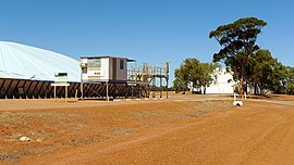
 Wialki grain receival point, 2014 | |
| Population | 112 (2006 census)[1] |
| Established | 1933 |
| Postcode(s) | 6473 |
| Elevation | 414 m (1,358 ft) |
| Location | |
| LGA(s) | Shire of Mount Marshall |
| State electorate(s) | Central Wheatbelt |
| Federal division(s) | Durack |
Wialki is a small town in the eastern Wheatbelt region of Western Australia. It is situated between Beacon and Bonnie Rock.
The town was formed as a result of an extension to the railway that was planned to pass through the area in 1929. The district surveyor suggested the station should be named Datjoin but the Railway department chose the name Wialki after the Aboriginal name of a nearby soak. The station was named in 1930 and the townsite was gazetted in 1933.[2] The meaning of the name is not known.
The surrounding areas produce wheat and other cereal crops. A second bulk wheat bin was constructed in town in 1940 just as the first bulk bin was filled.[3] The town is a receival site for Cooperative Bulk Handling.[4]
References
- ^ Australian Bureau of Statistics (25 October 2007). "Wialki (State Suburb)". 2006 Census QuickStats. Retrieved 20 April 2011.
- ^ "History of country town names – W". Western Australian Land Information Authority. Archived from the original on 14 March 2022. Retrieved 20 April 2011.
- ^ "Country news". The West Australian. Perth: National Library of Australia. 17 January 1940. p. 3. Retrieved 3 April 2013.
- ^ "CBH receival sites" (PDF). 2011. Retrieved 20 April 2011.
External links
![]() Media related to Wialki, Western Australia at Wikimedia Commons
Media related to Wialki, Western Australia at Wikimedia Commons
