
Yate: Difference between revisions
Arpingstone (talk | contribs) m Reverted edits by Jigman1166 (talk) to last version by Loon*i2d |
Jigman1166 (talk | contribs) |
||
| Line 90: | Line 90: | ||
== Amenities == |
== Amenities == |
||
The town has a skatepark at Peghill. The Common (open space) on Westerleigh Road (variously also know as Yate Common or The German Fields)is a popular spot for dog walking, nature watching, kite flying and for visits of circuses and fairs. |
The town has a skatepark at Peghill. The Common (open space) on Westerleigh Road (variously also know as Yate Common or The German Fields)is a popular spot for dog walking, nature watching, kite flying and for visits of circuses and fairs. It is also popular with "hippies" for picking magic mushrooms and as such you can often see the Police starting at one end and the "hippies" at the other in a competition to see who can pick the most. |
||
The land has recently been sold to a major housing company so that cheap hosing can be built for immigrants that are under represented in the local area. |
|||
The Common has a stretch of disused [[dual carriageway]] (locally called "The Road to Nowhere") which has been used for filming in TV programmes such as [[Casualty (TV series)|Casualty]], when filming on a real road was not feasible. |
The Common has a stretch of disused [[dual carriageway]] (locally called "The Road to Nowhere") which has been used for filming in TV programmes such as [[Casualty (TV series)|Casualty]], when filming on a real road was not feasible. |
||
Revision as of 15:33, 13 May 2008
- For the municipality in New Caledonia, see Yaté.
- For the tree species, see Eucalyptus cornuta.
Yate is a town at the southwest extremity of the Cotswold Hills, 12 miles (19 km) northeast of the city of Bristol, England. At the 2001 census its population was 21,789. The much smaller town of Chipping Sodbury (population 5,066) is contiguous with Yate to the east. The majority of the development from a village into a new town was in the 1960s as an overspill/commuter town for Bristol.
The town council is Yate Town Council [1].
South Gloucestershire Council[2] is the local council and is responsible for street care and refuse collection in the area.
The Yate & Chipping Sodbury Guide is a combined online guide for residents and visitors to Yate and Chipping Sodbury [3] and contains information on the area including the history of the area, business directory, schools and war time memories of former residents.
Location
The town is surrounded by countryside while within easy reach of the city of Bristol by car, bus or train. Yate railway station was closed by the Beeching Axe of January 1965, but was reopened in May 1989; the Brunel-built engine shed is preserved nearby. The Welsh border near Chepstow is 17 miles (27 km) away, 25 minutes drive from Yate.
Administration
National
At present, is represented in the UK Parliament by the constituency of Northavon - Steve Webb MP, but this will change to Thornbury and Yate in the UK General election of 2009 or 2010.
County
Yate was in Gloucestershire until 1974 when it became part of the newly-formed county of Avon. In 1996 the Avon authority was abolished and the area became part of the unitary authority of South Gloucestershire.
Local
Yate Town Council [4] provides local services.
History

The first mention of Yate is the existence of a religious house about AD 770; Yate is also mentioned in the Domesday Book of 1086. The name is derived from the Saxon word Giete or Gete meaning "a gateway into a forest area".
During the Saxon period and well into medieval times most of this part of south Gloucestershire was covered with forest but through the centuries the land was cleared for farming.
The town's parish church, St Mary's [5] was started in Norman times but was altered during the 15th century and was extensively restored in 1970. St Mary's Primary School[6], situated outside the churchyard walls, was built on the site of a former poor house.
It was opening of the railway station in 1844, as part of Bristol and Gloucester Railway, that established Yate, with Station Road becoming the central thoroughfare. It was around this road that the cattle and produce markets were held and where businesses were established. In the 1960s Yate was designated as a development area and the building boom began. The creation of a 'new town' included a large retail shopping area, sports and leisure development together with numerous public buildings.
When a new secondary school was to be constructed in the late 1970s, it was supposed to be 'Brinsham Green School' (after 'Brinsham Lane' at nearby Yate Rocks), but due to a spelling error it was called 'Brimsham Green School'.
The town experienced further expansion in the 1990s-2000s with the construction of housing at North Yate. The housing estate carried on with the corrupted name of 'Brimsham'. To locals the area is known as 'Brimsham Park'.
Yate Rail Yard
During World War II, a rail transfer yard was constructed for the United States Army probably as part of Operation Bolero to assist the build up of troops and stores prior to D-Day. On the site, two large storage sheds survive. At the end of World War II, the site was taken over by the Royal Navy and became known as the Sea Transport Stores Depot (the name persists locally to this day).Until recently the site was occupied by the Highways Agency but it is now derelict.
Oxford Archaeology [7] has been commissioned to undertake an investigation as to the military significance of this site. Also the opinions and view of Bristol Industrial Archaeological Society (BIAS) [8] have also been sought.
Twin towns
Industry
Prior to World War II, Yate had an aircraft manufacturing industry (Parnall). [9] During World War II, Parnalls specialized in making gun turrets. A number of people were killed in raids by the Luftwaffe on the factory in February and March of 1941 [10].
Yate has three natural products associated with it - limestone to the east, celestine or spar near the centre of the town, and coal to the west.
The need for limestone increased with the growth of roads while the demand for coal grew with the diminishing supply of timber. Celestine, the major strontium mineral,was first dug in the late 1880s and was initially used for the refining of sugar beet. At one time Yate’s celestine accounted for over 70 per cent of the worlds production. As it colours flames bright red its most important use however is in pyrotechnics, that is fireworks, military and signal flares, and in tracer bullets. The last commercial excavation of celestine from the Yate area was during the Vietnam War. In more recent times this mineral has been used in the electronics industries and in fluorescent markers. The mining company, Bristol Mineral and Land Co, closed in 1994.
Shopping

Construction of a pedestrianised shopping centre of around 100 shops (thought to be one of the first, in the UK, to be constructed in a small town) began in the early to mid 1960s. .[11]
The shopping centre was opened by Coronation Street's Elsie Tanner (Patricia Phoenix). An extension to West Walk was constructed in the early 90s, containing Kwik Save (now McDonalds, The Entertainer and Subway), Argos and other shops.
Centre shops include Burtons (clothes retailer), Woolworths, Tesco, Boots (Chemist), Halfords Metro, Iceland (supermarket), Argos, Superdrug and The Entertainer. Eating places in the Centre are McDonalds, Burger King, Subway and Boswells.
During the 1980s and into the mid 1990s, Yate Shopping Centre hosted Yate's annual festival. On opening day a celebrity launched the festival by releasing balloons and stayed to sign autographs. Celebrities have included - Carole Lee Scott in character as Grotbags (from Rod Hull and Emu's enemy), Timmy Mallet, Keith Chegwin, Ross Kemp (EastEnders' Grant Mitchell), Ken Morley (Coronation Street's Reg Holdsworth), David Neilson (Coronation Street's Roy Cropper), Beverley Callard (Coronation Street's Liz McDonald), Bob Carolgees and Spit the Dog, and the Milky Bar Kid. The festival also brought along a number of news presenters from HTV West including Bruce Hockin, Richard Wyatt and Peter Rowell.
In December 2006 the owners of the shopping centre (Dominion Corporate Trustees) announced plans to enlarge and modernise it. In Phase 1 the main change will be an enlargement of the existing Tesco supermarket, using up part of the centre's car park. To compensate for the loss, the store will be on "stilts" with parking beneath.
Also located near the shopping centre are Lidl, Morrisons and B & Q. There are two Tesco Express stores in Yate: one on Station Road (half way between the shopping centre and Yate Railway Station) and one in Brimsham Park.
B & Q was built in the mid to late 1980s (along with two small housing estates), on the site of the old Newmans electric motor factory (which was demolished in the mid 1980s).
Amenities
The town has a skatepark at Peghill. The Common (open space) on Westerleigh Road (variously also know as Yate Common or The German Fields)is a popular spot for dog walking, nature watching, kite flying and for visits of circuses and fairs. It is also popular with "hippies" for picking magic mushrooms and as such you can often see the Police starting at one end and the "hippies" at the other in a competition to see who can pick the most.
The land has recently been sold to a major housing company so that cheap hosing can be built for immigrants that are under represented in the local area.
The Common has a stretch of disused dual carriageway (locally called "The Road to Nowhere") which has been used for filming in TV programmes such as Casualty, when filming on a real road was not feasible.
Local Sport
Football
Yate Town F.C.[12],plays in Southern League Premier Division.
There is also a ladies football team, Yate Town Girls/Ladies FC [13], that plays in local leagues.
A junior team, Yate United F.C. [14], provides competitive youth football.
Netball
Chipping Sodbury Netball Club practices weekly at Yate Outdoor Sports Centre. They have several league teams, and train junior girls ranging from the ages of 11-16, and adults of all ages.
Athletics
Yate and District Athletic Club [15] are a track and field club based at the Yate Outdoor Sports Centre.
Hockey
Yate Hockey Club [16] run teams from adult through to junior.
Famous Inhabitants
- The author of the Harry Potter series of books, J. K. Rowling, was born in Yate, at Chipping Sodbury Hospital, and lived in early childhood at the nearby village of Winterbourne.
- Graffiti artist, Banksy[17] originates from Yate.[18]
- The actor Alan Medcroft lived his early life in Yate & Chipping Sodbury and still lives nearby.
Suburbs of Yate
- Goose Green
- Abbotswood
- Rodford
- Stover
- North Yate
- Brimsham Park
Gallery
-
 St. Mary's church tower
 -
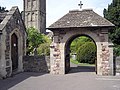 The lych gate. Inside this gate are the two war memorials
 -
 WW2 memorial
 -
 WW1 memorial
 -
 The Parnall memorial in the churchyard
 -
 Tombs in the churchyard, seen from the church tower
 -
 St. Mary's Church of England school in Church road
 -
 A very small part of Yate. The shopping centre is top right
 -
 The fire station (red doors), the ambulance station is to its right. In the foreground is middle to high income housing
 -
 A display of spring daffodils on Rodford Way
 -
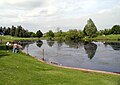 The lake in Kingsgate Park
 -
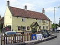 The White Lion pub at the shopping centre
 -
 Stanshawes Court Hotel, an 1871 Victorian mansion in Kingsgate Park


External links
- Yate & Chipping Sodbury Guide Guide for Residents and Visitors to Yate & Chipping Sodbury
- Chipping Sodbury Cricket Club nr Yate
- Sodbury Players Local amateur dramatics group in the Yate and Chipping Sodbury Area
- Yate & District Heritage Centre Official Website
- Stanshawe Band Stanshawe Band - named after the estates
- Yate Railway Station Station Information
- Yate Railway Station Bristol Railway Archive
- Yate Beat Avon and Somerset Constabulary.
- Local Focus Events and issues in Yate - Local Liberal Democrats web site
- Yate Town Supporters Club Yate Town F C Supporters Club and Football Forum
References
- ^ Yate Town Council
- ^ South Gloucestershire Council
- ^ The Yate & Chipping Sodbury Guide for residents and visitors to the area
- ^ Yate Town Council Official Website
- ^ St Mary, Yate Diocese of Bristol
- ^ St.Marys School, Yate Official Website
- ^ Oxford Archaeology Official Website
- ^ Bristol Industrial Archaeological Society (BIAS) Official Website
- ^ History of Parnall Aircraft.
- ^ The Bombing of Parnalls Aircraft Factory of Yate BBC WW2 Peoples War
- ^ Yate Shopping centre
- ^ Yate Town F.C Official Website of Yate F.C.
- ^ Yate Town Girls/Ladies FC
- ^ Yate United F.C. Official website of Yate United F.C.
- ^ Yate and District Athletic Club Official Website.
- ^ Yate Hockey Club Official Website.
- ^ Banksy's Website
- ^ On the trail of artist Banksy BBC News. Retrieved 12 February 2007
Literary References to Yate
Yate was awarded the 45th worst place to live in the UK, according to the Idler book of Crap Towns [1]
- ^ Idler book of Crap Towns Eds. Sam Jordison and Dan Kieran, Box Tree 2003)