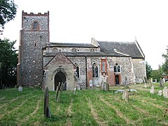
Yelverton, Norfolk
Appearance
| Yelverton | |
|---|---|
 St Mary's church, Yelverton | |
Location within Norfolk | |
| Area | 2.21 km2 (0.85 sq mi) |
| Population | 173 (2011 census) |
| • Density | 78/km2 (200/sq mi) |
| OS grid reference | TG293020 |
| Civil parish |
|
| District | |
| Shire county | |
| Region | |
| Country | England |
| Sovereign state | United Kingdom |
| Post town | NORWICH |
| Postcode district | NR14 |
| Police | Norfolk |
| Fire | Norfolk |
| Ambulance | East of England |
Yelverton is a village and civil parish in the English county of Norfolk, situated some 5 miles (8.0 km) south east of Norwich and closely associated with Alpington.[1]
The villages name probably means 'Geldfrith's farm/settlement'.[1]
The civil parish has an area of 2.21 km2 (0.85 sq mi) and had a population of 186 in 62 households in the 2001 census, the population falling to 173 at the 2011 Census.[2] For the purposes of local government, the parish falls within the district of South Norfolk.[2]
The village itself is just south of the A146 (on which lies Yelverton Garage) and is contiguous with Alpington to the south with which it shares its facilities, which include a duckpond, village hall and St. Mary's church.
References
- ^ "Key to English Place-names".
- ^ "Civil Parish population 2011". Retrieved 9 September 2015.
Notes
- ^ Ordnance Survey (2005). OS Explorer Map OL40 - The Broads. ISBN 0-319-23769-9.
- ^ Office for National Statistics & Norfolk County Council (2001). Census population and household counts for unparished urban areas and all parishes. Retrieved 2 December 2005.
External links
- Community website for Alpington and Yelverton
- St. Mary's Church
 Media related to Yelverton, Norfolk at Wikimedia Commons
- Yelverton on GENUKI
- Map sources for Yelverton, Norfolk.

