Little Coxwell
| Little Coxwell | |
|---|---|
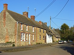
 Cottages in Little Coxwell | |
Location within Oxfordshire | |
| Population | 132 (2001 census)[1] |
| OS grid reference | SU2893 |
| Civil parish |
|
| District | |
| Shire county | |
| Region | |
| Country | England |
| Sovereign state | United Kingdom |
| Post town | Faringdon |
| Postcode district | SN7 |
| Dialling code | 01367 |
| Police | Thames Valley |
| Fire | Oxfordshire |
| Ambulance | South Central |
| UK Parliament | |
| Website | Welcome to Our Website |
Little Coxwell is a village and civil parish in South East England, about 1.5 miles (2.4 km) south of Faringdon and 0.8 miles (1.3 km) east of Great Coxwell. Little Coxwell was part of Berkshire until the 1974 local government boundary changes transferred the Vale of White Horse to Oxfordshire.[2] Cistercian monks of Beaulieu Abbey built the Church of England parish church of Saint Mary in the 12th century as a chapel of ease. Little Coxwell was a dependent chapelry of the ecclesiastical parish of Great Faringdon. In 1866 the civil parish was established.[3] The village has a public house, the Eagle Tavern.[4] The Hurlingham Polo Association, the governing body for polo in the UK, Ireland, and many other countries, has its office at Manor Farm, Little Coxwell.[5]
References
[edit]- ^ "Area selected: Vale of White Horse (Non-Metropolitan District)". Neighbourhood Statistics: Full Dataset View. Office for National Statistics. Archived from the original on 22 June 2011. Retrieved 1 April 2010.
- ^ Arnold-Baker, C. (1973). Local Government Act 1972. Butterworths.[page needed]
- ^ Vision of Britain website
- ^ The Eagle Tavern
- ^ Welcome to the Hurlingham Polo Association Archived 7 September 2009 at the Wayback Machine
Further reading
[edit]- Page, W.H.; Ditchfield, P.H., eds. (1924). A History of the County of Berkshire, Volume 4. Victoria County History. pp. 489–499.
- Pevsner, Nikolaus (1966). Berkshire. The Buildings of England. Harmondsworth: Penguin Books. pp. 167–168.
External links
[edit]


