
2022 Atlantic hurricane season: Difference between revisions
For the last time, the strongest hurricane is determined by pressure, not wind speeds. Fiona is the strongest hurricane so far. |
m ian windspeed |
||
| Line 8: | Line 8: | ||
| Last storm dissipated=Season ongoing |
| Last storm dissipated=Season ongoing |
||
| Track=2022 Atlantic hurricane season summary map.png |
| Track=2022 Atlantic hurricane season summary map.png |
||
| Strongest storm name=[[Hurricane Fiona|Fiona]]{{#tag:ref|The "strength" of a tropical cyclone is measured by the minimum barometric pressure, not wind speed. Most meteorological organizations rate the intensity of a storm by this figure, so the lower the minimum pressure of the storm, the more intense or "stronger" it is considered to be. The strongest winds were actually from [[Hurricane Ian|Ian]], at {{convert|135|kn|mph km/h|round=5|order=out|abbr=on}}.|group="nb"}} |
|||
| Strongest storm name=[[Hurricane Fiona|Fiona]] |
|||
| Strongest storm pressure=932 |
| Strongest storm pressure=932 |
||
| Strongest storm winds=115 |
| Strongest storm winds=115 |
||
| Average wind speed=1 |
|||
| Average wind speed=1 |
| Average wind speed=1 |
||
| Total depressions=10 |
| Total depressions=10 |
||
Revision as of 15:09, 28 September 2022
| 2022 Atlantic hurricane season | |
|---|---|
 Season summary map | |
| Seasonal boundaries | |
| First system formed | June 5, 2022 |
| Last system dissipated | Season ongoing |
| Strongest storm | |
| Name | Fiona[nb 1] |
| • Maximum winds | 130 mph (215 km/h) (1-minute sustained) |
| • Lowest pressure | 932 mbar (hPa; 27.52 inHg) |
| Seasonal statistics | |
| Total depressions | 10 |
| Total storms | 9 |
| Hurricanes | 4 |
| Major hurricanes (Cat. 3+) | 2 |
| Total fatalities | 40 total |
| Total damage | ≥ $400 million (2022 USD) |
| Related articles | |
The 2022 Atlantic hurricane season is the current cycle of the annual tropical cyclone season in the Atlantic Ocean in the Northern Hemisphere. The season officially began on June 1, and will end on November 30. These dates, adopted by convention, historically describe the period in each year when most subtropical or tropical cyclogenesis occurs in the Atlantic Ocean.[1] This year's first named storm, Tropical Storm Alex, developed five days after the start of the season, making this the first season since 2014 not to have a pre-season named storm.[2] There have been nine named tropical storms so far this season. Four of them strengthened into a hurricane, and two reached major hurricane intensity (Category 3 or higher on the Saffir–Simpson scale).
In July, Tropical Storm Bonnie formed and quickly made landfall along the Costa Rica–Nicaragua border. It then crossed over into the Pacific basin a day later, becoming the first to survive the crossover from the Atlantic to the Pacific since Hurricane Otto in 2016. The same day as Bonnie's crossover, Tropical Storm Colin unexpectedly formed inland over coastal South Carolina. It quickly weakened and dissipated the next day after moving into coastal North Carolina. Following this activity, tropical cyclogenesis was suppressed across the basin for several weeks by a combination of high wind shear, drier air, and the presence of the Saharan Air Layer.[3] As a result, this was the first season since 1997 in which no tropical cyclones formed in August, and the first season on record to do so during a La Niña year.[4] After a 60-day lull in tropical cyclone activity, Hurricanes Danielle and Earl formed on September 1 and 3 respectively, with Danielle becoming the season's first hurricane. The last season to have its first hurricane develop this late was 2013.[5] Activity then increased tremendously towards the end of the month as four named storms formed in quick succession. Among them, Hurricane Fiona became the season's first major hurricane on September 20, which is about three weeks later than when the first one typically forms,[6] and Hurricane Ian, which impacted Cuba as a high-end Category 3 hurricane.
Seasonal forecasts
| Source | Date | Named storms |
Hurricanes | Major hurricanes |
Ref |
| Average (1991–2020) | 14.4 | 7.2 | 3.2 | [7] | |
| Record high activity | 30 | 15 | 7† | [8] | |
| Record low activity | 4 | 2† | 0† | [8] | |
| CSU | December 9, 2021 | 13–16 | 6–8 | 2–3 | [9] |
| TSR | December 10, 2021 | 18 | 8 | 3 | [10] |
| TSR | April 6, 2022 | 18 | 8 | 4 | [11] |
| CSU | April 7, 2022 | 19 | 9 | 4 | [12] |
| TWC | April 14, 2022 | 20 | 8 | 4 | [13] |
| UA | April 14, 2022 | 14 | 7 | 3 | [14] |
| NCSU | April 20, 2022 | 17–21 | 7–9 | 3–5 | [15] |
| PSU | May 9, 2022 | 11-19 | N/A | N/A | [16] |
| UKMO* | May 23, 2022 | 18 | 9 | 4 | [17] |
| NOAA | May 24, 2022 | 14–21 | 6–10 | 3–6 | [18] |
| TSR | May 31, 2022 | 18 | 8 | 4 | [19] |
| CSU | June 2, 2022 | 20 | 10 | 5 | [20] |
| TWC | June 17, 2022 | 21 | 9 | 4 | [21] |
| UA | June 20, 2022 | 15 | 7 | 3 | [22] |
| TSR | July 5, 2022 | 18 | 9 | 4 | [23] |
| CSU | July 7, 2022 | 20 | 10 | 5 | [24] |
| UKMO | August 2, 2022 | 16 | 6 | 4 | [25] |
| NOAA | August 4, 2022 | 14–20 | 6–10 | 3–5 | [26] |
| CSU | August 4, 2022 | 18 | 8 | 4 | [26] |
| TWC | August 18, 2022 | 17 | 7 | 3 | [27] |
| Actual activity |
9 | 4 | 2 | ||
| * June–November only † Most recent of several such occurrences. (See all) | |||||
In advance of, and during, each hurricane season, several forecasts of hurricane activity are issued by national meteorological services, scientific agencies, and noted hurricane experts. These include forecasters from the United States National Oceanic and Atmospheric Administration (NOAA)'s Climate Prediction Center, Tropical Storm Risk (TSR), the United Kingdom's Met Office (UKMO), and Philip J. Klotzbach, William M. Gray and their associates at Colorado State University (CSU). The forecasts include weekly and monthly changes in significant factors that help determine the number of tropical storms, hurricanes, and major hurricanes within a particular year. According to NOAA and CSU, the average Atlantic hurricane season between 1991 and 2020 contained roughly 14 tropical storms, seven hurricanes, three major hurricanes, and an accumulated cyclone energy (ACE) index of 72–111 units.[28] Broadly speaking, ACE is a measure of the power of a tropical or subtropical storm multiplied by the length of time it existed. It is only calculated for full advisories on specific tropical and subtropical systems reaching or exceeding wind speeds of 39 mph (63 km/h).[7] NOAA typically categorizes a season as above-average, average, or below-average based on the cumulative ACE index, but the number of tropical storms, hurricanes, and major hurricanes within a hurricane season is sometimes also considered.[7]
Pre-season forecasts
On December 9, 2021, CSU issued an extended range forecast for the 2022 hurricane season, giving a 40% chance of near-average activity with 13–16 named storms, 6–8 hurricanes, 2–3 major hurricanes, and an ACE index of about 130 units. The forecast also gave a 25% chance that the ACE Index would end up being around 170 units, and a 25% likelihood the likelihood that the index would end up around 80.[9] TSR also issued an extended range forecast on December 10, 2021.[10] It predicted overall near-average tropical activity with its ACE index, anticipating 18 tropical storms, 8 hurricanes and 3 intense hurricanes to form during the season. One of their factors was the expectation of a neutral El Niño-Southern Oscillation condition by the third quarter of 2022. This outlook had "large uncertainties".[10]
On April 7, CSU issued their first extended range seasonal forecast for the 2022 Atlantic hurricane season, predicting well above-average activity, with 19 named storms, 9 hurricanes, 4 major hurricanes and an ACE index of 160 units. Their factors supporting an active hurricane season included above average-sea surface temperatures in the subtropical Atlantic Ocean and Caribbean Sea, and a cool neutral ENSO or weak La Niña pattern, corresponding to a low chance of an El Niño.[29] On April 14, 2022, University of Arizona (UA) issued its seasonal prediction for a slightly above-average hurricane season, with 14 named storms, seven hurricanes, three major hurricanes, and an ACE index of 129 units.[14] North Carolina State University (NCSU) made its prediction for the season on April 20, calling for an above-average season with 17 to 21 named storms, 7 to 9 hurricanes, and 3 to 5 major hurricanes.[15]
On May 23, UKMO issued their own forecast for the 2022 season, predicting an above average season with 18 named storms, 9 hurricanes, and 4 major hurricanes, with a 70% chance that each of these statistics will fall between 13 and 23, 6 and 12, and 2 and 6, respectively.[17] The following day, NOAA's Climate Prediction Center issued their forecasts for the season, predicting a 65% chance of above-average activity and 25% chance for below-average activity, with 14–21 named storms, 6–10 hurricanes, and 3–6 major hurricanes.[18]
Mid-season forecasts
On June 2, CSU updated their extended range seasonal forecast, increasing the amount of tropical cyclones to 20 named storms, 10 hurricanes, 5 major hurricanes, and an overall ACE index of 180 units. This was done after later analysis of lower chances of an El Niño during the season, as well as a warmer than average tropical Atlantic.[30] On June 20, 2022, University of Arizona (UA) updated its seasonal prediction, which is very similar to its April prediction, with 15 named storms, seven hurricanes, three major hurricanes, and an ACE index of 131 units.[22] On July 5, TSR released their third forecast for the season, slightly increasing their numbers to 18 named storms, 9 hurricanes, and 4 major hurricanes. This prediction was largely based on the persistence of the weak La Niña into the third quarter of the year.[23] On July 7, CSU did not make changes to their updated prediction of 20 named storms, 10 hurricanes, and 5 major hurricanes.[24] UKMO's updated forecast on August 2 called for 16 named storms, 6 hurricanes, and 4 major hurricanes.[25] Two days later, NOAA and CSU each revised their activity outlook slightly downward, though both still predicted that the season would end up being busier than the 30-year average. The revisions were made in part because of the relative slow start to the season (as compared to the past couple), with only three short-lived named storms as of the start of August.[26]
Seasonal summary


The 2022 season was the first season since 2014 to not have a pre-season named storm.[31] Activity began with the formation of Tropical Storm Alex on June 5, after several days of slow development while traversing the Gulf of Mexico and then moving over Central Florida. The storm peaked at near-hurricane strength before becoming extratropical over the Central North Atlantic. At the beginning of July, Tropical Storm Bonnie formed in the Southern Caribbean Sea and made landfall shortly thereafter near the Costa Rica–Nicaragua border. It then crossed over into the into the Pacific basin a day later, the first storm to do so since Hurricane Otto in 2016,[32] where it would become a category 3 hurricane. On the same day that Bonnie crossed over, a low-pressure system over coastal South Carolina abruptly organized into Tropical Storm Colin. It would be a short-lived storm as it became disorganized shortly after forming and dissipated the next day over eastern North Carolina. Tropical activity then ceased, with no tropical cyclones forming in almost two months. It became the first season to not have a tropical cyclone form in August since 1997.[33] One disturbance over the Gulf of Mexico during the middle of the month was briefly designated as a potential tropical cyclone, but it did not organize into a tropical cyclone before moving inland over Northeastern Mexico.

Tropical activity ultimately resumed with the formation of Tropical Storm Danielle over the Central Atlantic on September 1. The storm intensified a hurricane the following day, the latest "first hurricane of the season" since 2013.[34] It remained nearly stationary far to the west of the Azores for several days before moving northeastward and becoming extratropical on September 8 without affecting any land areas. Additionally, a slow-developing disturbance east of the Lesser Antilles became organized and developed into Tropical Storm Earl late on September 2–3.[35] It strengthened into a hurricane, tracked east of Bermuda, fluctuating between Category 1 and 2 intensity, and then became extratropical near Newfoundland on September 10. Four days later, Tropical Storm Fiona formed in the Central Atlantic. Fiona eventually became a hurricane, striking both Puerto Rico and the Dominican Republic before becoming the season's first major hurricane as it passed by the Turks and Caicos Islands on September 20. That same day, Tropical Storm Gaston formed over the Central Atlantic. Fiona would strengthen into a category 4 hurricane as it passed west of Bermuda while Gaston would strike the Azores. As Fiona transitioned into a powerful extratropical cyclone that would strike Nova Scotia on September 23, Tropical Storm Hermine and Tropical Depression Nine formed in the Eastern Atlantic and the Carribbean Sea respectively, marking the first time since 2020 that four tropical cyclones were active simultaneously in the Atlantic basin.[36] Tropical Depression Nine would rapidly stregthen into Hurricane Ian as the three other storms dissipated, and make landfall on Cuba as a high-end Category 3 hurricane.
This season's ACE index as of 03:00 UTC on September 28, as calculated by Colorado State University using data from the NHC, is approximately 69.7 units.[37] This number represents the sum of the squares of the maximum sustained wind speed (knots) for all named storms while they are at least tropical storm intensity, divided by 10,000. Therefore, tropical depressions are not included.[38]
Systems
Tropical Storm Alex
| Tropical storm (SSHWS) | |
  | |
| Duration | June 5 – June 6 |
|---|---|
| Peak intensity | 70 mph (110 km/h) (1-min); 984 mbar (hPa) |
On May 31, a large low-pressure area developed near the Yucatán Peninsula, partially related to the Pacific basin remnants of Hurricane Agatha interacting with an upper-level trough over the Gulf of Mexico.[39] The low moved eastward over the Yucatán Peninsula, producing a large area of disorganized showers and thunderstorms over the peninsula and northwestern Caribbean Sea on June 1–2.[40] Due to the threat the developing system posed to Cuba, the Florida Keys and South Florida, the National Hurricane Center initiated advisories on it, designating it as Potential Tropical Cyclone One at 21:00 UTC on June 2.[41] As it proceeded northeastward over the Gulf of Mexico, the disturbance was being buffeted by 25–35 mph (35–55 km/h) southwesterly shear, which limited its ability to intensify. On June 3, two Hurricane Hunters missions into the system found deep convection ongoing near and to the east of the estimated center, but no conclusive evidence of a closed circulation.[42][43] Early the following day, the broad and poorly-defined center of the disturbance moved over southwestern Florida.[44] Then, after moving into the Atlantic later that same day, a well-defined center formed with sufficient convection, resulting in it being upgraded to Tropical Storm Alex at 06:00 UTC on June 5.[45] The storm intensified some later that same day, attaining sustained winds of 70 mph (110 km/h) as it passed west of Bermuda.[46] Soon thereafter, Alex began its extra-tropical transition, a process that was complete by 21:00 UTC on June 6.[47] Several days later, the system passed to the west of Scotland and near the Faroe Islands,[48][49] before rapidly weakening while moving toward Norway, which it reached on June 13.[50]
While a potential tropical cyclone, what would later become Alex produced significant rainfall across western Cuba and South Florida, which resulted in flash flooding across both regions. During a 30 hour period on June 2–3, Paso Real de San Diego in the province of Pinar del Río recorded about 12 inches (301 mm) of rain, and Playa Girón in Matanzas received over 8 inches (193 mm).[51] There were four storm related deaths in Cuba,[52][53] and numerous homes and bridges were damaged by the flooding.[54] Between 7:00 a.m. local time on June 3, and 10:00 p.m. the following day, Miami saw just over 11 inches (28 cm) of rain, while Hollywood had just over 9 inches (23 cm). Naples, near where the storm's estimated center came onshore, also had close to 9 inches (23 cm).[53] Across Broward County and Miami-Dade County, there were a combined 3,543 power outages.[55]
Tropical Storm Bonnie
| Tropical storm (SSHWS) | |
  | |
| Duration | July 1 – July 2 (Exited basin) |
|---|---|
| Peak intensity | 50 mph (85 km/h) (1-min); 997 mbar (hPa) |
A tropical wave moved off the northwest coast of Africa south of 10°N on June 23, producing a large but disorganized area of showers and thunderstorms.[56][57] The low-level wind circulation associated with the system became better defined[58] and thunderstorm activity increased[59] on June 25–26, as it moved along a west to west-northwesterly track toward the southernmost Windward Islands. A NOAA Hurricane Hunters mission on June 27, reported tropical-storm-strength winds on the north side of the disturbance, but indicated that it had not yet shown a well-defined closed circulation. Although it could not yet be classified as a tropical cyclone, due to the threat the system posed to the Lesser Antilles, the National Hurricane Center (NHC) initiated advisories on it as Potential Tropical Cyclone Two later that same day.[60][61] Later, after moving through the southern Windward Islands late on June 28, the disturbance sped west at 26 mph (43 km/h) toward the coast of South America.[62] Over the next couple of days, the system passed just to the north of Venezuela, where it was hindered from developing a distinct low-level circulation due to its fast forward speed and its interaction with land. Yet all the while it generated sustained winds of tropical-storm strength.[63] As the disturbance moved toward Central America on the morning of July 1, it became sufficiently organized to be classified as a tropical storm and was given the name Bonnie.[64] Embedded in a low-shear and warm SST environment, Bonnie started to steadily intensify.[65] At 03:00 UTC on July 2, Bonnie made landfall near the Costa Rica–Nicaragua border at its peak intensity within the Atlantic with sustained winds of 50 mph (85 km/h).[66] Bonnie then crossed Central America and exited into the Eastern Pacific basin 12 hours later.[67]
Bonnie and its precursor disturbance produced gusty winds and heavy rainfall as it tracked through the southern Caribbean Sea.[63] In Nicaragua, authorities reported four deaths in relation to the storm.[68]
Tropical Storm Colin
| Tropical storm (SSHWS) | |
  | |
| Duration | July 2 – July 3 |
|---|---|
| Peak intensity | 40 mph (65 km/h) (1-min); 1011 mbar (hPa) |
An area of low pressure formed offshore of Savannah, Georgia, on the morning of July 1, and moved inland across coastal South Carolina later that same day. During this time the system unexpectedly developed with persistent deep convection forming close to the center and quickly becoming well organized.[69] On July 2, at 09:00 UTC, Tropical Storm Colin formed about 50 mi (80 km) southwest of Myrtle Beach, South Carolina, with sustained winds of 40 mph (65 km/h) and an estimated central pressure of 1011 mbar (29.9 inHg).[70] The storm became increasingly disorganized later that day, with its circulation becoming elongated from north-northeast to south-southwest due to high wind shear and continued land interaction.[71] By 03:00 UTC on July 3, after passing Wilmington, North Carolina, Colin had weakened to a tropical depression.[72] The system dissipated over eastern North Carolina nine hours later.[73]
Most of Colin's heavy rains and strong winds remained out over the Atlantic due to its proximity to the coast and northwesterly shear of around 25 mph (35 km/h).[74] Rainfall totals inland ranged from 2–3 in (51–76 mm) in parts of the Midlands of South Carolina to near 7 in (180 mm) near Charleston, South Carolina.[75] A Fourth of July weekend event in Charleston was cancelled because of flooding at the event site, as was a festival in Southport, North Carolina.[76] Winds from Colin's remnants produced high surf along the North Carolina coast on July 3, and one man drowned at a beach in Oak Island.[77][78]
Hurricane Danielle
| Category 1 hurricane (SSHWS) | |
  | |
| Duration | September 1 – September 8 |
|---|---|
| Peak intensity | 90 mph (150 km/h) (1-min); 972 mbar (hPa) |
On August 30, an area of low pressure formed along a decaying frontal zone over the central subtropical Atlantic.[79] The disturbance quickly organized and developed into Tropical Depression Five early on September 1 before strengthening into Tropical Storm Danielle later that evening.[80] The storm continued to strengthen and became a Category 1 hurricane on September 2.[81] It stalled the following day, caught south of a blocking high, and weakened back into a tropical storm due to upwelling of cooler waters and some dry air.[82] Later, the storm began drifting toward the west, where it again strengthened into a hurricane overnight September 3–4.[83] After turning northwestward, Danielle reached its peak intensity with sustained winds of 90 mph (150 km/h) early on September 5,[84] It then moved over a relatively cool part of the Gulf Stream and weakened to a low-end Category 1 hurricane.[85] Danielle briefly re-intensified when it moved over marginally warm waters on September 7, but resumed a weakening trend shortly afterwards.[86] Danielle weakened to a tropical storm on September 8[87] before transitioning into an extratropical cyclone later that day.[88]
As an extratropical cyclone, Danielle brought strong winds and heavy rain to Portugal on September 12–13, which caused flash flooding, landslides and downed trees. The heaviest rainfall amounts were estimated to be in Alentejo and Algarve regions.[89][90] Heavy rain was observed in Spain.[91]
Hurricane Earl
| Category 2 hurricane (SSHWS) | |
  | |
| Duration | September 3 – September 10 |
|---|---|
| Peak intensity | 105 mph (165 km/h) (1-min); 954 mbar (hPa) |
A tropical wave producing widespread disorganized showers and thunderstorms moved off the west coast of Africa on August 25.[92] After moving across the eastern and central tropical Atlantic, the disturbance encountered environmental conditions east of the Leeward Islands that were only marginally conducive for tropical cyclone development.[93] After struggling against high wind shear for several days, the disturbance was finally able to become better organized and developed into Tropical Storm Earl early on September 3.[94] A burst of deep convection occurred near Earl's center during the evening of September 5, and a Hurricane Hunters mission into the storm later that night reported that it briefly strengthened to very near hurricane strength.[95] Earl's intensity continued to fluctuate throughout much of the next day due to continued effects of westerly deep-layer shear.[96] Later that day, the shear began to quickly diminish, and Earl became better organized, strengthening into a hurricane around 00:00 UTC on September 7.[97] By 03:00 UTC on September 8, Earl reached Category 2 strength while moving northward; Hurricane Hunters data showed it to have an eye of almost 60 mi (90 km) and a fairly symmetric wind field.[98] Three hours later the hurricane attained peak sustained winds of 105 mph (165 km/h).[99] Despite being forecasted to continue strengthening into a Category 4 hurricane, Earl's inner core was repeatedly interrupted due to dry air entrainment and it fluctuated in strength the following day while passing well to the east of Bermuda despite being over very warm sea surface temperatures of around 84–86 °F (28–29 °C).[100] It briefly weakened to Category 1 strength early on September 9,[101] before rebounding to Category 2 strength with a peak intensity of 105 mph (165 km/h) sustained winds and a minimum barometric pressure of 954 mbar (28.17 inHg). At this time, Earl had become a large hurricane, with hurricane-force winds extending outward up to 80 miles (130 km) from the center and tropical-storm-force winds extend outward up to 275 miles (445 km).[102] After maintaining this intensity for several hours, Earl weakened to a Category 1 hurricane again at 15:00 UTC on September 10, then transitioned into an extratropical low south of Cape Race, Newfoundland six hours later.[103]
Two people died on September 4 in Salinas, Puerto Rico, after being struck by lightning while riding a jet ski.[104][105] Bermuda was buffeted with sustained winds of 35 mph (60 km/h) as Hurricane Earl passed within about 90 mi (145 km) of the island's eastern coast; higher gusts were reported, including one of 67 mph (108 km/h) at the National Museum of Bermuda. There were localized power outages across the archipelago but no large-scale damage was observed.[106][107] During a 36-hour period September 10–12, 7–8 in (175–200 mm) of rain fell in the St. Johns area, causing overflowing along the Waterford River which led to urban flooding. Similar rainfall amounts were also reported in communities throughout the Avalon Peninsula. Additionally, the cyclone caused rough surf which damaged the breakwater on the coast in the area of Trepassey, Newfoundland and Labrador, causing localized flooding.[108]
Hurricane Fiona
| Category 4 hurricane (SSHWS) | |
  | |
| Duration | September 14 – September 24 |
|---|---|
| Peak intensity | 130 mph (215 km/h) (1-min); 932 mbar (hPa) |
Early on September 12, the NHC began to monitor a tropical wave over the central tropical Atlantic for gradual development, though environmental conditions for development were assessed as only marginally favorable.[109] Even so, shower and thunderstorm activity within the disturbance began to become more concentrated later that same day,[110] then increased and became better organized during the next day.[111] The circulation associated with the system became more defined and persisted overnight and into the morning of September 14, attaining sufficient organization to designated as Tropical Depression Seven later that day.[112] Despite the continued effects of moderate westerly shear and dry mid-level air flow,[113] new satellite imagery indicated the depression had strengthened, thus at 01:45 UTC on September 15, it became Tropical Storm Fiona.[114] The storm moved over Guadeloupe as a 50 mph (85 km/h) tropical storm around 00:00 UTC on September 16 and then entered the eastern Caribbean.[115] Early on September 18, the storm strengthened into a hurricane as it approached Puerto Rico,[116] before making landfall there that afternoon about 15 mi (25 km) south-southeast of Mayaguez, with maximum sustained winds of 85 mph (140 km/h).[117] It then emerged over the Mona Passage, and strengthened slightly further before making landfall near Boca de Yuma, Dominican Republic, with maximum sustained winds of 90 mph (150 km/h).[118] Fiona weakened slightly as it moved overland, but began to rapidly strengthen once back over water, becoming a category 2 hurricane by 21:00 UTC on September 19,[119] and then a Category 3 major hurricane early the next morning near Grand Turk Island.[6] Further intensification resulted in it reaching Category 4 strength with maximum sustained winds of 130 mph (210 km/h) at 06:00 UTC on September 21,[120] while moving northward across very warm waters with surface temperatures of 84–86 °F (29–30 °C).[121][122]
Fiona's winds then held steady for a couple of days while its central pressure dropped to 932 mbar (27.52 inHg) at 00:00 UTC on September 22,[123] the hurricane's peak intensity as a tropical cyclone. Fiona's wind field also began to grow in size and tropical storm-strength winds impacted Bermuda for several hours on September 23, despite Fiona passing well west of the island.[124] Fiona, weakened to a Category 3 hurricane that morning,[125] but briefly rebounded to Category 4 strength several hours later as it moved northeastward at about 35 mph (56 km/h),[126] before weakening once more to a Category 3 strength late that same day.[127] Shortly thereafter, Fiona weakened again before turning northward and quickly transitioning into a large and powerful post-tropical cyclone as it approached the coast of Nova Scotia at 03:00 UTC on September 24.[128] Soon thereafter, the system made landfall in eastern Nova Scotia 07:00 UTC with 100 mph (160 km/h) and a pressure of 931 mbar (27.49 inHg), slowing rapidly as it did so.[129] It then moved over Cape Breton Island with hurricane strength winds, although it continued to weaken as it moved northward.[130] When the NHC issued its final advisory on Fiona at 21:00 UTC that same day, it was centered about 80 mi (130 km) northwest of Port aux Basques, Newfoundland, and had maximum sustained winds of 70 mph (110 km/h).[131]
Altogether, at least 22 deaths have been attributed to Fiona. One death was confirmed in Guadeloupe, while at least two deaths were confirmed in the Dominican Republic and three in Canada.[121][132] In Puerto Rico, as of September 24, the Department of Health had confirmed 16 deaths related to the path of the system.[133][134] Still recovering from the effects of Hurricane Maria in 2017, torrential rains fell island-wide on September 18–19, up to 25 in (640 mm) in some regions, causing destructive flash flooding that washed out roads and bridges. In addition, the effects of the storm resulted in the island-wide power grid being knocked out.[118][135] In Canada, homes and businesses across The Maritimes, Quebec's North Coast and Newfoundland were destroyed and several hundred thousand people were left without power in Fiona's wake.[132]
Tropical Storm Gaston
| Tropical storm (SSHWS) | |
  | |
| Duration | September 20 – September 26 |
|---|---|
| Peak intensity | 65 mph (100 km/h) (1-min); 995 mbar (hPa) |
A tropical wave moved off the coast of West Africa into the tropical Atlantic on September 12, producing disorganized showers and thunderstorms, but doing so in an environment just marginally favorable for development.[136] By September 15, the wave had moved generally westward to about midway between Africa and the Lesser Antilles.[137] There the showers and thunderstorms continued within the northern portion of the wave.[138] The disturbance then transitioned into a trough of low pressure on September 17, as it moved slowly northward.[139] After showing little sigs of development over the next two day, a low-pressure formed within the trough and convection began to organize around it. Upon producing a well-defined center and persistent deep convection, became Tropical Depression Eight at 15:00 UTC on September 20.[140] The depression strengthened into Tropical Storm Gaston six hours later while it was located about 990 mi (1595 km) west of the Azores.[141] Gaston quickly intensified, attaining peak sustained winds of 65 mph (105 km/h) the following day, just 18 hours after formation.[142] However, additional strengthening was prevented as dry air became entrained into the eastern portion of the circulation.[143] Gaston then maintained its intensity for two days as it accelerated northeastward toward the western Azores despite being in an environment of moderate to strong shear, relatively dry air, and cool sea surface temperatures.[144] On September 23, Gaston began to interact with shortwave trough/baroclinic zone, which shunted all of its the deep convection to the northeastern portion of the storm and it weakened slightly as it slowed down and began an anticyclonic loop through the central Azores along the southern side of a mid-level ridge.[145][146] However, Gaston restrenghtened later that day as convection reformed over northern and western sides of its circulation and it reached its peak intensity with sustained winds of 65 mph (100 km/h) and a minimum barometric pressure of 995 mbar (29.38 inHg) at 15:00 UTC.[147][148] Relentless wind shear then stripped Gaston of its deep convection and the storm began to weaken again early the next morning as it continued its loop, which it completed later that day as it passed just west of the central Azores.[149][150] Now moving westward away from the Azores, Gaston dropped to minimal tropical storm strength, but restrengthened for a third time as a large burst of convection developed over the northern portion of the circulation as it interacted with an upper-level trough.[151] Its winds increased to 50 mph (80 km/h) on the morning of September 25 and it maintained this intensity for most of the day as it center reformed under the convective mass.[152][153] However, Gaston soon moved away from the trough and wind shear quickly removed the remaining deep convection from the storm late that afternoon.[154] Convection did not reform over Gaston and it weakened for the final time before being declared a post-tropical cyclone at 03:00 UTC on September 26.[155]
Heavy rainfall and tropical storm forced winds was reported across the Azores, especially in the western and central islands.[156] A weather station at Horta on Faial Island measured a wind gust to 41 mph (66 km/h) as Gaston passed through.[157]
Hurricane Ian
| |||
|---|---|---|---|
Current storm status Category 4 hurricane (1-min mean) | |||
| |||
| As of: | 10:00 a.m. EDT (14:00 UTC) September 28 | ||
| Location: | 26°12′N 82°42′W / 26.2°N 82.7°W ± 15 nm About 60 mi (95 km) W of Naples, Florida About 65 mi (105 km) SW of Punta Gorda, Florida | ||
| Sustained winds: | 135 kn (155 mph; 250 km/h) (1-min mean) gusting to 165 kn (190 mph; 305 km/h) | ||
| Pressure: | 937 mbar (27.67 inHg) | ||
| Movement: | NNE at 9 kn (10 mph; 17 km/h) | ||
| See more detailed information. | |||


On September 19, the NHC began tracking a tropical wave to the east of the Windward Islands for possible gradual development.[158] Two days later, the disturbance passed over Trinidad and Tobago as it entered the southeast Caribbean, and then near to the ABC Islands and the northern coast of South America. On September 22, while moving west-northwestward, it showed signs of increasing organization, though strong wind shear of 30–35 mph (45–55 km/h) generated by the upper-level outflow from Hurricane Fiona was inhibiting development of a tropical depression.[159] Even so, a well-defined circulation was able to form within the disturbance that day; its convection then increased and become persistent over night into the next day, resulting in it being designated Tropical Depression Nine early on September 23.[160] The organization of the depression improved slowly over the course of that day, and it became Tropical Storm Ian at 03:00 UTC on September 24.[161] The high wind shear from Fiona was gone completely by the next day,[36] as the storm entered the central Caribbean where it encountered wind, water and atmosphere conditions favorable for intensification: light wind shear, warm 86°F (30°C) sea surface temperatures and a mid-level relative humidity of 70%.[162] In this environment, Ian quickly become better organized and strengthened into an Category 1 hurricane at 09:00 UTC on September 26.[163] Twelve hours later, it intensified into a Category 2 hurricane as it approached the western tip of Cuba.[164] At 08:30 UTC on September 27, Ian made landfall near La Coloma, in Pinar del Río Province, Cuba, as a high-end Category 3 hurricane, with sustained winds of 125 mph (205 km/h).[165] After about six hours over land, Ian emerged off the north coast of Cuba into the Gulf of Mexico, still a major hurricane – though a slightly weaker one.[166] After going through an eyewall replacement cycle, Ian quickly strengthened, reaching Category 4 intensity at 09:00 UTC on September 28.[167] Ian would continue to rapidly intensify into a high-end Category 4 hurricane by 10:35 UTC.
While in the early stages of developing, the system brought gusty winds and heavy rain to Trinidad and Tobago,[168][169] the ABC Islands and to the northern coast of South America on September 21–22.[159]
Current storm information
As of 10:00 a.m. EDT (2:00 UTC) September 28, Hurricane Ian is located within 15 nautical miles of 24°54′N 82°54′W / 24.9°N 82.9°W, about 110 miles (175 km) southwest of Naples, Florida and about 15 miles (25 km) north of the Dry Tortugas. Maximum sustained winds are about 135 knots (155 mph; 250 km/h) with gusts up to 165 knots (190 mph; 305 km/h). The minimum barometric pressure is 937 mbar (27.67 inHg), and the system is moving north-northeast at 9 knots (10 mph; 17 km/h). Hurricane-force winds extend outward up to 40 miles (65 km) from the center of Ian, and tropical-storm-force winds extend outward up to 140 miles (220 km) from the center.
For the latest official information, see:
- The NHC's latest public advisory on Hurricane Ian
- The NHC's latest forecast advisory on Hurricane Ian
- The NHC's latest forecast discussion on Hurricane Ian
Watches and warnings
Template:HurricaneWarningsTable
Tropical Storm Hermine
| Tropical storm (SSHWS) | |
  | |
| Duration | September 23 – September 25 |
|---|---|
| Peak intensity | 40 mph (65 km/h) (1-min); 1002 mbar (hPa) |
On September 22, a tropical wave being monitored by the NHC emerged off the coast of West Africa into the tropical Atlantic east of Cabo Verde.[159] It quickly organized, becoming Tropical Depression Ten at 15:00 UTC on September 23,[170] and then strengthened into Tropical Storm Hermine six hours later.[171] It is one of few tropical cyclones on record (going back to 1851) to form this far east, and to track between the Cabo Verde Islands and the coast of Africa.[159] Development beyond a weak tropical storm was stymied by southwesterly shear into the next day, as it moved northward. On account of the shear, Hermine weakened into a tropical depression at 21:00 UTC on September 24,[172] and then degenerated into a post-tropical low the next day.[173]
Hermine brought heavy rainfall to the Canary Islands, causing localized flooding and downed trees. More than 140 flights were cancelled across the archipelago.[174]
Tropical Depression Eleven
| |||
|---|---|---|---|
| |||
| As of: | 11:00 a.m. AST (15:00 UTC) September 28 | ||
| Location: | 16°06′N 34°24′W / 16.1°N 34.4°W ± 15 nm About 690 mi (1,110 km) W of Cabo Verde Islands | ||
| Sustained winds: | 30 kn (35 mph; 55 km/h) (1-min mean) gusting to 40 kn (45 mph; 75 km/h) | ||
| Pressure: | 1008 mbar (29.77 inHg) | ||
| Movement: | N at 8 kn (9 mph; 15 km/h) | ||
| See more detailed information. | |||


Other systems

On August 15, the NHC first noted the potential for tropical cyclone development in the southwestern Gulf of Mexico from a tropical wave that was located over the central Caribbean Sea.[175] The low emerged over the Gulf early on August 19 producing disorganized showers.[176] Due to the threat the developing system posed to northeastern Mexico and South Texas, the NHC initiated advisories on it as Potential Tropical Cyclone Four at 21:00 UTC that same day.[177] As the disturbance moved northwestward toward the Gulf coast of Mexico on August 20, a Hurricane Hunters mission found that it was still a surface trough.[178] Later that day, it moved inland, striking the coast about 60 mi (95 km) southwest of the mouth of the Rio Grande.[179] With that, the window of opportunity for tropical development closed, and the NHC issued its last advisory on the system at 03:00 UTC on August 21.[180] The disturbance brought heavy rain to coastal Tamaulipas and coastal South Texas.[179]
Storm names
The following list of names will be used for named storms that form in the North Atlantic in 2022. Retired names, if any, will be announced by the World Meteorological Organization in the spring of 2023. The names not retired from this list will be used again in the 2028 season.[181] This is the same list used in the 2016 season, with the exceptions of Martin and Owen, which replaced Matthew and Otto, respectively.[182]
|
|
Season effects
This is a table of all of the storms that have formed in the 2022 Atlantic hurricane season. It includes their duration, names, landfall(s)–denoted by bold location names – damages, and death totals. Deaths in parentheses are additional and indirect (an example of an indirect death would be a traffic accident), but were still related to that storm. Damage and deaths include totals while the storm was extratropical, a wave, or a low, and all of the damage figures are in 2022 USD.
| Saffir–Simpson scale | ||||||
| TD | TS | C1 | C2 | C3 | C4 | C5 |
| Storm name |
Dates active | Storm category at peak intensity |
Max 1-min wind mph (km/h) |
Min. press. (mbar) |
Areas affected | Damage (USD) |
Deaths | Ref(s) | ||
|---|---|---|---|---|---|---|---|---|---|---|
| Alex | June 5–6 | Tropical storm | 70 (110) | 984 | Yucatán Peninsula, Western Cuba, Florida, Northern Bahamas, Bermuda, Southern Iceland, Northern Scotland, Faroe Islands, Central Norway | Minimal | 4 | [52] | ||
| Bonnie | July 1–2 | Tropical storm | 50 (85) | 997 | Trinidad and Tobago, Grenada, Colombia, Venezuela, ABC Islands, Central America (before crossover) | Minimal | 4 | [68] | ||
| Colin | July 2–3 | Tropical storm | 40 (65) | 1011 | South Atlantic United States | Minimal | 1 | [78] | ||
| Danielle | September 1–8 | Category 1 hurricane | 90 (150) | 972 | Western Iberian Peninsula | Unknown | None | |||
| Earl | September 3–10 | Category 2 hurricane | 105 (165) | 954 | Northern Leeward Islands, Puerto Rico, Bermuda, Newfoundland | Minimal | 2 | [104][107] [108] | ||
| Fiona | September 14–24 | Category 4 hurricane | 130 (215) | 932 | Lesser Antilles, Puerto Rico, Dominican Republic, Eastern Lucayan Archipelago, Bermuda, Eastern Canada | ≥$400 million | 27 | [121][132] [133][134] | ||
| Gaston | September 20–26 | Tropical storm | 65 (100) | 995 | Azores | Unknown | None | |||
| Ian | September 23–present | Category 4 hurricane | 155 (250) | 937 | Trinidad and Tobago, Venezuela, Colombia, ABC islands, Jamaica, Cayman Islands, Cuba, Florida | Unknown | 2 | |||
| Hermine | September 23–25 | Tropical storm | 40 (65) | 1002 | Senegal, Mauritania, Canary Islands | Minimal | None | |||
| Eleven | September 28–present | Tropical depression | 35 (55) | 1008 | None | None | None | |||
| Season aggregates | ||||||||||
| 10 systems | June 5 – Season ongoing | 155 (250) | 937 | ≥$400 million | 40 | |||||
See also
- Weather of 2022
- Tropical cyclones in 2022
- Atlantic hurricane season
- 2022 Pacific hurricane season
- 2022 Pacific typhoon season
- 2022 North Indian Ocean cyclone season
- South-West Indian Ocean cyclone seasons: 2021–22, 2022–23
- Australian region cyclone seasons: 2021–22, 2022–23
- South Pacific cyclone seasons: 2021–22, 2022–23
Notes
- ^ The "strength" of a tropical cyclone is measured by the minimum barometric pressure, not wind speed. Most meteorological organizations rate the intensity of a storm by this figure, so the lower the minimum pressure of the storm, the more intense or "stronger" it is considered to be. The strongest winds were actually from Ian, at 155 mph (250 km/h).
References
- ^ "Hurricanes Frequently Asked Questions". Miami, Florida: NOAA Atlantic Oceanographic and Meteorological Laboratory. June 1, 2021. Retrieved January 30, 2022.
- ^ Donegan, Brian (May 25, 2022). "For first time since 2014, Atlantic hurricane season might not start early". New York City, New York: Fox Weather. Retrieved May 31, 2022.
- ^ Erdman, Jonathan (August 22, 2022). "It's The Atlantic Hurricane Season's Least Active Start In 30 Years". weather.com. The Weather Channel. Retrieved August 24, 2022.
- ^ Masters, Jeff (August 31, 2022). "Hinnamnor in Pacific kicks off as Cat 5; Atlantic appears set to end its slumber". New Haven, Connecticut: Yale climate Connections. Retrieved August 31, 2022.
- ^ Croft, Jay (September 2, 2022). "Danielle becomes first hurricane of the 2022 Atlantic season". CNN. Retrieved September 3, 2022.
- ^ a b Masters, Jeff; Henson, Bob (September 20, 2022). "Cat 3 Fiona rakes Turks and Caicos; Disturbance 98L approaches Caribbean". New Haven, Connecticut: Yale climate Connections. Retrieved September 20, 2022.
- ^ a b c "Background Information: North Atlantic Hurricane Season". College Park, Maryland: Climate Prediction Center. May 22, 2019. Retrieved April 5, 2021.
- ^ a b "Atlantic hurricane best track (HURDAT version 2)" (Database). United States National Hurricane Center. April 5, 2023. Retrieved October 4, 2024.
 This article incorporates text from this source, which is in the public domain.
- ^ a b "Colorado State University releases first look at 2022 Hurricane Season". Cape Coral, Florida: WFTX-TV. December 9, 2021. Retrieved May 25, 2022.
- ^ a b c Saunders, Marc; Lea, Adam (December 10, 2021). "Extended Range Forecast for Atlantic Hurricane Activity in 2022" (PDF). tropicalstormrisk.com. London, UK: University College London. Retrieved December 10, 2021.
- ^ Saunders, Marc; Roberts, Frank; Lea, Adam (April 6, 2022). "April Forecast Update for North Atlantic Hurricane Activity in 2022" (PDF). tropicalstormrisk.com. London, UK: University College London. Retrieved April 7, 2022.
- ^ "Extended Range Forecast of Atlantic Seasonal Hurricane Activity and Landfall Strike Probability for 2022" (PDF). Fort Collins, Colorado: Colorado State University. April 7, 2022. Retrieved April 7, 2022.
- ^ Belles, Jonathan (April 14, 2022). "TWC Hurricane Outlook Released: 2022 Atlantic Season Expected to Be Another Busy One". The Weather Channel. Retrieved April 14, 2022.
- ^ a b Davis, Kyle; Zeng, Xubin (April 14, 2022). "Forecast of the 2022 Hurricane Activities over the North Atlantic" (PDF). Tucson, Arizona: University of Arizona. Retrieved April 14, 2022.
- ^ a b Peake, Tracy (April 20, 2022). "NC State Researchers Predict Active Hurricane Season". Raleigh, North Carolina: North Carolina State University. Retrieved April 20, 2022.
- ^ "ESSC: Earth System Science Center - North Atlantic Hurricane Season Prediction".
- ^ a b "North Atlantic tropical storm seasonal forecast 2022".
- ^ a b "NOAA predicts above-normal 2022 Atlantic Hurricane Season | National Oceanic and Atmospheric Administration".
- ^ Lea, Adam; Nick, Wood (May 31, 2022). "Pre-Season Forecast Update for North Atlantic Hurricane Activity in 2022" (PDF). tropicalstormrisk.com. London, UK: University College London. Retrieved June 1, 2022.
- ^ "Extended Range Forecast of Atlantic Seasonal Hurricane Activity and Landfall Strike Probability for 2022" (PDF). Fort Collins, Colorado: Colorado State University. June 2, 2022. Retrieved June 2, 2022.
- ^ "Atlantic Hurricane Season Outlook Update: The Weather Company Increases Number of Expected Storms". Atlanta, Georgia: The Weather Channel. June 17, 2022. Retrieved June 17, 2022.
- ^ a b Davis, Kyle; Zeng, Xubin (June 20, 2022). "Forecast of the 2022 Hurricane Activities over the North Atlantic". Tucson, Arizona: University of Arizona. Retrieved June 21, 2022.
- ^ a b Lea, Adam; Nick, Wood (July 5, 2022). "July Forecast Update for North Atlantic Hurricane Activity in 2022" (PDF). tropicalstormrisk.com. London, UK: University College London. Retrieved July 5, 2022.
- ^ a b "Extended Range Forecast of Atlantic Seasonal Hurricane Activity and Landfall Strike Probability for 2022" (PDF). Fort Collins, Colorado: Colorado State University. July 7, 2022. Retrieved July 7, 2022.
- ^ a b "Forecast for the whole 2022 season".
- ^ a b c Henson, Bob (August 4, 2022). "Latest outlooks for Atlantic hurricane season: Less frenzied, but still above average". New Haven Connecticut: Yale Climate Connections. Retrieved August 6, 2022.
- ^ "Atlantic hurricane season outlook updated". Atlanta, Georgia: The Weather Channel. August 18, 2022. Retrieved August 18, 2022.
- ^ Saunders, Marc; Lea, Adam (December 9, 2020). "Extended Range Forecast for Atlantic Hurricane Activity in 2021" (PDF). tropicalstormrisk.com. London, UK: University College London. Retrieved April 16, 2022.
- ^ Klotzbach, Philip [@philklotzbach] (April 7, 2022). "Atlantic seasonal #hurricane forecast from @ColoradoStateU calls for above-average season: 19 named storms, 9 hurricanes & 4 major hurricanes. Reasons for above-average forecast include predicted lack of #ElNino and warmer than normal subtropical Atlantic https://t.co/uauRVHEjql https://t.co/7dzsFjQBN9" (Tweet). Archived from the original on April 7, 2022. Retrieved April 10, 2022 – via Twitter.
- ^ Klotzbach, Philip [@philklotzbach] (June 2, 2022). "Atlantic seasonal #hurricane forecast update from @ColoradoStateU calls for very active season: 20 named storms, 10 hurricanes & 5 major hurricanes. Forecast increased from April due to low chance of #ElNino & warmer than normal tropical Atlantic https://tropical.colostate.edu/Forecast/2022-06.pdf https://twitter.com/philklotzbach/status/1532361400277839873" (Tweet). Retrieved June 2, 2022 – via Twitter.
- ^ Donegan, Brian (May 25, 2022). "For first time since 2014, Atlantic hurricane season might not start early". FOX Weather. Retrieved September 6, 2022.
- ^ Masters, Jeff; Henson, Bob (July 2, 2022). "Tropical Storm Colin forms along the South Carolina coast". New Haven Connecticut: Yale Climate Connections. Retrieved July 2, 2022.
- ^ Masters, Jeff (August 31, 2022). "Hinnamnor in Pacific kicks off as Cat 5; Atlantic appears set to end its slumber". Yale Climate Connections. Retrieved September 6, 2022.
- ^ CNN, Jay Croft. "Danielle becomes first hurricane of the 2022 Atlantic season". CNN. Retrieved September 6, 2022.
{{cite web}}:|last=has generic name (help) - ^ Henson, Bob; Masters, Jeff (September 4, 2022). "Korea braces and the Atlantic churns; New Pacific system may affect Mexico and U.S." New Haven, Connecticut: Yale Climate Connections. Retrieved September 14, 2022.
- ^ a b Henson, Bob; Masters, Jeff (September 24, 2022). "Fiona sets Atlantic Canada reeling; Ian forms in Caribbean". New Haven, Connecticut: Yale Climate Connections. Retrieved September 25, 2022.
- ^ "Real-Time North Atlantic Ocean Statistics by Storm for 2022". Fort Collins, Colorado: Colorado State University. Retrieved September 14, 2022.
- ^ Klotzbach, Philip; Bell, Michael (April 7, 2022). "Extended Range Forecast of Atlantic Seasonal Hurricane Activity and Landfall Strike Probability for 2022" (PDF). Fort Collins, Colorado: Colorado State University. pp. 6, 22. Retrieved June 7, 2022.
- ^ Papin, Philippe (May 31, 2022). Tropical Weather Outlook (Report). Miami, Florida: National Hurricane Center. Retrieved June 2, 2022.
- ^ Beven, Jack (June 2, 2022). Tropical Weather Outlook (Report). Miami, Florida: National Hurricane Center. Retrieved June 2, 2022.
- ^ Beven, Jack (June 2, 2022). Potential Tropical Cyclone One Advisory Number 1 (Report). Miami, Florida: National Hurricane Center. Retrieved June 2, 2022.
- ^ Berg, Robbie (June 3, 2022). Potential Tropical Cyclone One Discussion Number 3 (Report). Miami, Florida: National Hurricane Center. Retrieved June 5, 2022.
- ^ Beven, Jack (June 3, 2022). Potential Tropical Cyclone One Discussion Number 5 (Report). Miami, Florida: National Hurricane Center. Retrieved June 5, 2022.
- ^ Beven, Jack (June 4, 2022). Potential Tropical Cyclone One Discussion Number 8 (Report). Miami, Florida: National Hurricane Center. Retrieved June 5, 2022.
- ^ Papin, Philippe; Blake, Eric (June 5, 2022). Tropical Storm Alex Intermediate Advisory Number 10A (Report). Miami, Florida: National Hurricane Center. Retrieved June 5, 2022.
- ^ Brown, Daniel (June 5, 2022). Tropical Storm Alex Discussion Number 14 (Report). Miami, Florida: National Hurricane Center. Retrieved June 6, 2022.
- ^ Zelinsky, David (June 6, 2022). Post-Tropical Cyclone Alex Discussion Number 17 (Report). Miami, Florida: National Hurricane Center. Retrieved June 7, 2022.
- ^ Single Location Forecast - 7 Day. orkneyharbours.com (Report). June 11, 2022. Archived from the original on June 12, 2022. Retrieved June 11, 2022.
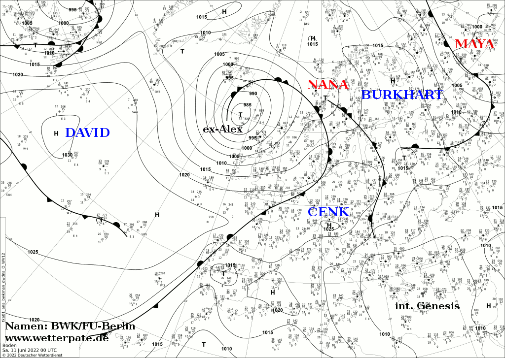
- ^ Deutscher Wetterdienst (June 11, 2022). "Analyse of 00 UTC on June 11 2022" (in German). Free University of Berlin. Retrieved June 13, 2022.
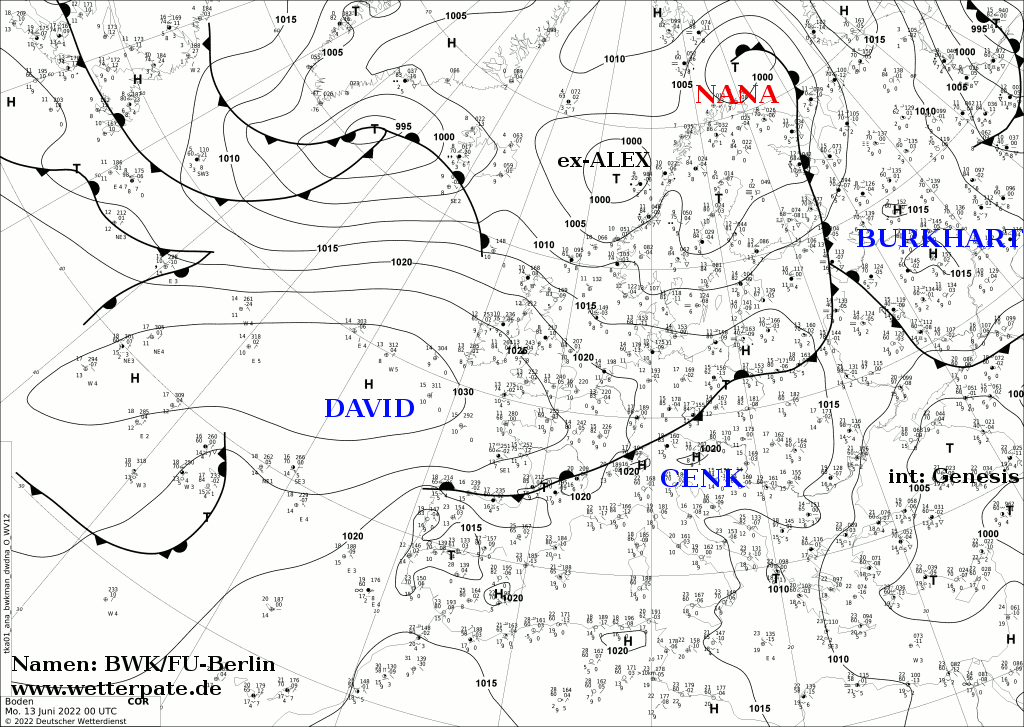
{{cite web}}: CS1 maint: url-status (link) - ^ Deutscher Wetterdienst (June 13, 2022). "Analyse of 00 UTC on June 13 2022" (in German). Free University of Berlin. Retrieved June 13, 2022.
{{cite web}}: CS1 maint: url-status (link) - ^ Davies, Richard (June 4, 2022). "Cuba – Deadly Flash Floods After 300mm of Rain". floodlist.com. Retrieved June 6, 2022.
- ^ a b "Tormenta Alex causa estragos: Elevan a cuatro los muertos en Cuba por las fuertes lluvias" [Storm Alex wreaks havoc: Deaths in Cuba rise to four due to heavy rains] (in Spanish). El Diario. EFE. June 6, 2022. Retrieved June 22, 2022.
- ^ a b Tribou, Richard Tribou (June 5, 2022). "Strengthening Tropical Storm Alex finally forms after flooding Florida". Orlando Sentinel. Archived from the original on June 14, 2022. Retrieved June 5, 2022.
- ^ Tribou, Richard (June 4, 2022). "No-name tropical system floods Florida, still expected to become Tropical Storm Alex". Orlando Sentinel. Archived from the original on June 4, 2022. Retrieved June 4, 2022.
- ^ Sosa, Samantha; Bilizos, Elitsa; Beyer, Brandon; Estrada, Lorena; Jones, Tavares (June 4, 2022). "Areas of South Florida impacted by flooding due to heavy rains". WSVN Miami. Archived from the original on June 4, 2022. Retrieved June 4, 2022.
- ^ Hagen, Andrew; Berg, Robbie (June 23, 2022). Two Day Graphical Tropical Weather Outlook (Report). Miami, Florida: National Hurricane Center. Retrieved June 23, 2022.
- ^ Masters, Jeff; Henson, Bob (June 24, 2022). "Unusual early-season threat in Atlantic's main development region". New Haven, Connecticut: Yale Climate Connections. Retrieved June 29, 2022.
- ^ Reinhart, Brad (June 25, 2022). Two Day Graphical Tropical Weather Outlook (Report). Miami, Florida: National Hurricane Center. Retrieved June 25, 2022.
- ^ Richardson, Blake; Bucci, Lisa (June 26, 2022). Two Day Graphical Tropical Weather Outlook (Report). Miami, Florida: National Hurricane Center. Retrieved June 26, 2022.
- ^ Pasch, Richard (June 27, 2022). Potential Tropical Cyclone Two Discussion Number 1 (Report). Miami, Florida: National Hurricane Center. Retrieved June 27, 2022.
- ^ Henson, Bob (June 27, 2022). "Tropical storm warnings up for southernmost Lesser Antilles ahead of Potential Tropical Cyclone 2". New Haven, Connecticut: Yale Climate Connections. Retrieved June 29, 2022.
- ^ Beven, Jack (June 28, 2022). Potential Tropical Cyclone Two Discussion Number 6 (Report). Miami, Florida: National Hurricane Center. Retrieved June 30, 2022.
- ^ a b Masters, Jeff (June 29, 2022). "Disturbance 95L threatens heavy rains for Texas; disturbance PTC 2 speeds across southern Caribbean". New Haven, Connecticut: Yale Climate Connections. Retrieved June 30, 2022.
- ^ Cangialosi, John; Hogsett, Wallace (July 1, 2022). Tropical Storm Bonnie Tropical Cyclone Update (Report). Miami, Florida: National Hurricane Center. Retrieved June 30, 2022.
- ^ Hogsett, Wallace (July 1, 2022). Tropical Storm Bonnie Advisory Number 17 (Report). Miami, Florida: National Hurricane Center. Retrieved July 5, 2022.
- ^ Beven, Jack (July 1, 2022). Tropical Storm Bonnie Advisory Number 18 (Report). Miami, Florida: National Hurricane Center. Retrieved July 2, 2022.
- ^ Hogsett, Wallace (July 2, 2022). Tropical Storm Bonnie Discussion Number 20 (Report). Miami, Florida: National Hurricane Center. Retrieved July 2, 2022.
- ^ a b "Reportan al menos cuatro muertos tras el paso de tormenta Bonnie en Nicaragua" [At least four deaths are reported after the passage of storm Bonnie in Nicaragua]. Infobae (in Spanish). Archived from the original on July 4, 2022. Retrieved July 4, 2022.
- ^ Berg, Robbie (July 2, 2022). Tropical Storm Colin Discussion Number 1 (Report). Miami, Florida: National Hurricane Center. Retrieved July 2, 2022.
- ^ Berg, Robbie (July 2, 2022). Tropical Storm Colin Advisory Number 1 (Report). Miami, Florida: National Hurricane Center. Retrieved July 2, 2022.
- ^ Cangialosi, John (July 2, 2022). Tropical Storm Colin Discussion Number 3 (Report). Miami Florida: National Hurricane Center. Retrieved July 4, 2022.
- ^ Beven, Jack (July 2, 2022). Tropical Depression Colin Advisory Number 4 (Report). Miami, Florida: National Hurricane Center. Retrieved July 3, 2022.
- ^ Berg, Robbie (July 3, 2022). Remnants Of Colin Discussion Number 5 (Report). Miami, Florida: National Hurricane Center. Retrieved July 3, 2022.
- ^ Cangialosi, John (July 2, 2022). Tropical Storm Colin Discussion Number 2 (Report). Miami, Florida: National Hurricane Center. Retrieved July 4, 2022.
- ^ Smith, Cory (July 3, 2022). "Showers and Storms possible Sunday Afternoon". Columbia, South Carolina: WLTX. Retrieved July 4, 2022.
- ^ "Tropical Storm Colin threatens a wet weekend for Carolinas". Washington, North Carolina: WITN. Associated Press. July 2, 2022. Archived from the original on July 2, 2022. Retrieved July 3, 2022.
- ^ Puente, Nathaniel (July 3, 2022). "Hickory man drowns at North Carolina beach". Charlotte, North Carolina: WCNC. Retrieved July 5, 2022.
- ^ a b Davis, Corey (July 5, 2022). "The Tropics Come A-Colin". Raleigh, North Carolina: North Carolina State Climate Office. Retrieved July 5, 2022.
- ^ Bucci, Lisa; Pasch, Richard (August 31, 2022). Tropical Weather Outlook (Report). Miami, Florida: National Hurricane Center. Retrieved September 1, 2022.
- ^ Bucci, Lisa; Cangialosi, John (September 1, 2022). Tropical Storm Danielle Advisory Number 2 (Report). Miami, Florida: National Hurricane Center. Retrieved September 1, 2022.
- ^ Rinehart, Brad (September 2, 2022). Hurricane Danielle Advisory Number 6 (Report). Miami, Florida: National Hurricane Center. Retrieved September 2, 2022.
- ^ Beven, Jack (September 3, 2022). Tropical Storm Danielle Discussion Number 9 (Report). Miami, Florida: National Hurricane Center. Retrieved September 4, 2022.
- ^ Roberts, Dave (September 4, 2022). Tropical Storm Danielle Discussion Number 12 (Report). Miami, Florida: National Hurricane Center. Retrieved September 4, 2022.
- ^ Roberts, Dave (September 5, 2022). Hurricane Danielle Discussion Number 16 (Report). Miami, Florida: National Hurricane Center. Retrieved September 6, 2022.
- ^ Zelinsky, David (September 5, 2022). Hurricane Danielle Discussion Number 18 (Report). Miami, Florida: National Hurricane Center. Retrieved September 6, 2022.
- ^ Blake, Eric (September 7, 2022). Hurricane Danielle Advisory Number 26 (Report). Miami, Florida: National Hurricane Center. Retrieved September 8, 2022.
- ^ Latto, Andy (September 8, 2022). Tropical Storm Danielle Discussion Number 29 (Report). Miami, Florida: National Hurricane Center. Retrieved September 8, 2022.
- ^ Zelinsky, David (September 8, 2022). "Post-Tropical Cyclone Danielle Discussion 30". Miami, Florida: National Hurricane Center. Retrieved September 13, 2022.
- ^ Graça, Alfredo (September 15, 2022). "Extratropical storm Danielle batters Portugal: floods, chaos and landslides". yourweather.co.uk. Meteored. Retrieved September 19, 2022.
- ^ "Portugal – Floods and Landslides Cause Severe Damage in Manteigas – FloodList". floodlist.com. Retrieved September 20, 2022.
- ^ "Storm Danielle affecting the mainland, but will it hit Mallorca?". Majorca Daily Bulletin. September 12, 2022. Retrieved September 20, 2022.
- ^ Berg, Robbie (August 25, 2022). Tropical Weather Outlook (Report). Miami, Florida: National Hurricane Center. Retrieved September 3, 2022.
- ^ Beven, Jack (September 2, 2022). Tropical Weather Outlook (Report). Miami, Florida: National Hurricane Center. Retrieved September 3, 2022.
- ^ Berg, Robbie (September 2, 2022). Tropical Storm Earl Advisory Number 1 (Report). Miami, Florida: National Hurricane Center. Retrieved September 3, 2022.
- ^ Berg, Robbie (September 6, 2022). Tropical Storm Earl Discussion Number 14 (Report). Miami, Florida: National Hurricane Center. Retrieved September 7, 2022.
- ^ Bucci, Lisa; Pasch, Richard (September 6, 2022). Hurricane Earl Discussion Number 17 (Report). Miami, Florida: National Hurricane Center. Retrieved September 7, 2022.
- ^ Bucci, Lisa; Pasch, Richard (September 6, 2022). Hurricane Earl Advisory Number 16A (Report). Miami, Florida: National Hurricane Center. Retrieved September 6, 2022.
- ^ Bucci, Lisa; Pasch, Richard (September 7, 2022). Hurricane Earl Discussion Number 21 (Report). Miami, Florida: National Hurricane Center. Retrieved September 8, 2022.
- ^ Berg, Robbie (September 8, 2022). Hurricane Earl Advisory Number 22 (Report). Miami, Florida: National Hurricane Center. Retrieved September 8, 2022.
- ^ Henson, Bob; Masters, Jeff (September 9, 2022). "Fierce winds, heavy rains hit Southern California on Kay's fringes". New Haven, Connecticut: Yale Climate Connections. Retrieved September 9, 2022.
- ^ Bucci, Lisa; Pasch, Richard (September 9, 2022). Hurricane Earl Advisory Number 25 (Report). Miami, Florida: National Hurricane Center. Retrieved September 9, 2022.
- ^ Zelinsky, David (September 9, 2022). Hurricane Earl Advisory Number 28 (Report). Miami, Florida: National Hurricane Center. Retrieved September 9, 2022.
- ^ Beven, Jack (September 10, 2022). Hurricane Earl Advisory Number 32 (Report). Miami, Florida: National Hurricane Center. Retrieved September 10, 2022.
- ^ a b "Mueren hombre y mujer tras impacto de rayo" [Man and woman die after lightning strike]. Primera Hora (in Spanish). Guaynabo, Puerto Rico. September 4, 2022. Retrieved September 4, 2022.
- ^ "Identifican a hombre y mujer que murieron tras ser impactados por rayo en Salinas" [They identify a man and woman who died after being struck by lightning in Salinas] (in Spanish). Telemundo Puerto Rico. September 5, 2022. Retrieved September 5, 2022.
- ^ Johnston-Barnes, Owain (September 9, 2022). "Hurricane Earl 3am update: some gusts remain but the worst has passed". The Royal Gazette. Hamilton, Bermuda. Retrieved September 12, 2022.
- ^ a b Bell, Jonathan; Lagan, Sarah (September 10, 2022). "Residents praised for taking Earl seriously". The Royal Gazette. Hamilton, Bermuda. Retrieved September 12, 2022.
- ^ a b "Heavy downpour overflowing riverbanks, flooding streets in St. John's area". CBC News. September 12, 2022. Retrieved September 12, 2022.
- ^ Papin, Philippe (September 12, 2022). Tropical Weather Outlook (Report). Miami, Florida: National Hurricane Center. Retrieved September 14, 2022.
- ^ Roberts, Dave (September 12, 2022). Tropical Weather Outlook (Report). Miami, Florida: National Hurricane Center. Retrieved September 14, 2022.
- ^ Roberts, Dave (September 13, 2022). Tropical Weather Outlook (Report). Miami, Florida: National Hurricane Center. Retrieved September 14, 2022.
- ^ Brown, Daniel (September 14, 2022). Tropical Depression Seven Discussion Number 1 (Report). Miami, Florida: National Hurricane Center. Retrieved September 14, 2022.
- ^ Brown, Daniel (September 14, 2022). Tropical Depression Seven Discussion 2 (Report). Miami, Florida: National Hurricane Center. Retrieved September 14, 2022.
- ^ Cangialosi, John (September 14, 2022). Tropical Storm Fiona Tropical Cyclone Update (Report). Miami, Florida: National Hurricane Center. Retrieved September 14, 2022.
- ^ Cangialosi, John (September 16, 2022). Tropical Storm Fiona Intermediate Advisory Number 10A (Report). Miami, Florida: National Hurricane Center. Retrieved September 17, 2022.
- ^ Pasch, Richard (September 18, 2022). Hurricane Fiona Advisory Number 17 (Report). Miami, Florida: National Hurricane Center. Retrieved September 18, 2022.
- ^ Pasch, Richard; Berg, Robbie (September 18, 2022). Hurricane Fiona Tropical Cyclone Update (Report). Miami, Florida: National Hurricane Center. Retrieved September 18, 2022.
- ^ a b Masters, Jeff; Henson, Bob (September 18, 2022). "Hurricane Fiona deluges Puerto Rico; Typhoon Nandamol hits Japan". New Haven, Connecticut: Yale Climate Connections. Retrieved September 19, 2022.
- ^ Samenow, Jason (September 19, 2022). "Fiona rapidly strengthening as it pulls away from Dominican Republic". The Washington Post. Retrieved September 20, 2022.
- ^ Beven, Jack (September 21, 2022). Hurricane Fiona Advisory 27A (Report). Miami, Florida: National Hurricane Center. Retrieved September 26, 2022.
- ^ a b c Masters, Jeff; Henson, Bob (September 21, 2022). "Atlantic on fire: Cat 4 Fiona, TS Gaston, and a concerning Caribbean system". New Haven, Connecticut: Yale Climate Connections. Retrieved September 21, 2022.
- ^ Beven, Jack (September 21, 2022). Hurricane Fiona Advisory 27A (Report). Miami, Florida: National Hurricane Center. Retrieved September 26, 2022.
- ^ Berg, Robbie (September 22, 2022). Hurricane Fiona Advisory 34A (Report). Miami, Florida: National Hurricane Center. Retrieved September 26, 2022.
- ^ Masters, Jeff; Henson, Bob (September 23, 2022). "TD 9 forecast calls for major hurricane for Florida; Fiona aims colossal blow at Canada". New Haven, Connecticut: Yale Climate Connections. Retrieved September 24, 2022.
- ^ Beven, Jack (September 23, 2022). Hurricane Fiona Advisory 36 (Report). Miami, Florida: National hurricane Center. Retrieved September 26, 2022.
- ^ Cangialosi, John; Snell, Cody (September 23, 2022). Hurricane Fiona Advisory Number 37 (Report). College Park, Maryland: NWS Weather Prediction Center. Retrieved September 26, 2022.
- ^ Pasch, Richard (September 23, 2022). Hurricane Fiona Advisory Number 38 (Report). Miami, Florida: National Hurricane Center. Retrieved September 23, 2022.
- ^ Pasch, Richard (September 23, 2022). Post-Tropical Cyclone Fiona Advisory Number 39 (Report). Miami, Florida: National Hurricane Center. Retrieved September 23, 2022.
- ^ Beven, Jack (September 24, 2022). Post-Tropical Cyclone Fiona Discussion 40 (Report). Miami, Florida: National Hurricane Center. Retrieved September 26, 2022.
- ^ Hanna, Jason; Cullinane, Susannah; Burnside, Tina (September 24, 2022). "'It is surreal': Canada's Atlantic coast residents describe devastation as Fiona wipes away homes and knocks out power for thousands". CNN. Retrieved September 24, 2022.
- ^ Cangialosi, John (September 24, 2022). Post-Tropical Cyclone Fiona Discussion 42 (Report). Miami, Florida: National Hurricane Center. Retrieved September 26, 2022.
- ^ a b c "Atlantic Canada expects slow recovery from Fiona's wrath". CBC News. September 25, 2022. Retrieved September 25, 2022.
- ^ a b Figueroa Cancel, Alex (September 24, 2022). "Suman 16 las muertes relacionadas a los efectos del paso del huracán Fiona, según informe del gobierno". El Nuevo Día. Retrieved September 25, 2022.
- ^ a b CyberNews (September 24, 2022). "Salud informa de 16 muertes asociadas al huracán Fiona". Noticel. Retrieved September 25, 2022.
- ^ El-Bawab, Nadine; Hoyos, Joshua Hoyos; Jacobo, Julia (September 19, 2022). "Hurricane Fiona strengthening after wreaking havoc in Puerto Rico". ABC News. Retrieved September 19, 2022.
- ^ Roberts, Dave (September 12, 2022). Two-Day Graphical Tropical Weather Outlook (Report). Miami, Florida: National Hurricane Center. Retrieved September 27, 2022.
- ^ Cangialosi, John (September 15, 2022). Five-Day Graphical Tropical Weather Outlook (Report). Miami, Florida: National Hurricane Center. Retrieved September 23, 2022.
- ^ Berg, Robbie (September 16, 2022). Five-Day Graphical Tropical Weather Outlook (Report). Miami, Florida: National Hurricane Center. Retrieved September 23, 2022.
- ^ Berg, Robbie (September 17, 2022). Five-Day Graphical Tropical Weather Outlook (Report). Miami, Florida: National Hurricane Center. Retrieved September 23, 2022.
- ^ Cangialosi, John; Pereira, Frank; Montgomery, Kim (September 20, 2022). Tropical Depression Eight Discussion Number 1 (Report). College Park, Maryland: NWS Weather Prediction Center. Retrieved September 20, 2022.
- ^ Cangialosi, John; Kebede, Mussie (September 20, 2022). Tropical Storm Gaston Advisory Number 2 (Report). College Park, Maryland: NWS Weather Prediction Center. Retrieved September 23, 2022.
- ^ Papin, Philippe (September 21, 2022). Tropical Storm GastonAdvisory 4 (Report). Miami, Florida: National Hurricane Center. Retrieved September 26, 2022.
- ^ Tropical Storm Gaston Discussion 6. www.nhc.noaa.gov (Report). Retrieved September 26, 2022.
- ^ "Tropical Storm GASTON Discussion 9". www.nhc.noaa.gov. Retrieved September 26, 2022.
- ^ Roberts, Dave (September 23, 2022). Tropical Storm Gaston Intermediate Advisory Number 11A (Report). Miami, Florida: National Hurricane Center. Retrieved September 24, 2022.
- ^ Roberts, Dave (September 23, 2022). Tropical Storm Gaston Discussion Number 12 (Report). Miami, Florida: National Hurricane Center. Retrieved September 24, 2022.
- ^ "Tropical Storm GASTON Discussion 13". www.nhc.noaa.gov. Retrieved September 26, 2022.
- ^ "Tropical Storm GASTON Advisory 13". www.nhc.noaa.gov. Retrieved September 26, 2022.
- ^ "Tropical Storm GASTON Discussion 14". www.nhc.noaa.gov. Retrieved September 26, 2022.
- ^ Bucci, Lisa (September 24, 2022). Tropical Storm Gaston Discussion Number 18...Corrected (Report). Miami, Florida: National Hurricane Center. Retrieved September 24, 2022.
- ^ "Tropical Storm GASTON Discussion 19". www.nhc.noaa.gov. Retrieved September 26, 2022.
- ^ "Tropical Storm GASTON Advisory 19". www.nhc.noaa.gov. Retrieved September 26, 2022.
- ^ "Tropical Storm GASTON Discussion 21". www.nhc.noaa.gov. Retrieved September 26, 2022.
- ^ "Tropical Storm GASTON Discussion 22". www.nhc.noaa.gov. Retrieved September 26, 2022.
- ^ "Post-Tropical Cyclone GASTON Discussion 23". www.nhc.noaa.gov. Retrieved September 26, 2022.
- ^ "Gaston turns post-tropical in the eastern Atlantic". spectrumnews1.com. Retrieved September 26, 2022.
- ^ "Tropical Storm GASTON Advisory 14A". www.nhc.noaa.gov. Retrieved September 26, 2022.
- ^ Roberts, Dave (September 19, 2022). "Five-Day Graphical Tropical Weather Outlook". Miami, Florida: National hurricane Center. Retrieved September 22, 2022.
- ^ a b c d Masters, Jeff; Henson, Bob (September 22, 2022). "Cat 4 Fiona steams toward Canada; Caribbean disturbance 98L a major concern". New Haven, Connecticut: Yale Climate Connections. Retrieved September 22, 2022.
- ^ Papin, Philippe (September 23, 2022). Tropical Depression Nine Discussion Number 1 (Report). Miami, Florida: National Hurricane Center. Retrieved September 23, 2022.
- ^ Berg, Robbie (September 23, 2022). Tropical Storm Ian Discussion Number 4 (Report). Miami, Florida: National Hurricane Center. Retrieved September 23, 2022.
- ^ Masters, Jeff; Henson, Bob (September 25, 2022). "Ian's future remains murky; Cat 4 Noru hits the Philippines". New Haven, Connecticut: Yale Climate Connections. Retrieved September 26, 2022.
- ^ Brown, Daniel; Roberts, Dave (September 26, 2022). Hurricane Ian Discussion Number 13 (Report). Miami, Florida: National Hurricane Center. Retrieved September 26, 2022.
- ^ Reinhart, Brad (September 26, 2022). Hurricane Ian Advisory Number 15 (Report). Miami, Florida: National Hurricane Center. Retrieved September 26, 2022.
- ^ Latto, Andrew; Brown, Daniel (September 27, 2022). Hurricane Ian Tropical Cyclone Update (Report). Miami, Florida: National Hurricane Center. Retrieved September 27, 2022.
- ^ Masters, Jeff; Henson, Bob (September 27, 2022). "Extremely dangerous Ian pounds Cuba, enters the Gulf of Mexico". New Haven, Connecticut: Yale Climate Connections. Retrieved September 27, 2022.
- ^ "Hurricane IAN Advisory 22". www.nhc.noaa.gov. Retrieved September 28, 2022.
- ^ "T&T sees flooding, roofs blown off". Trinidad Express Newspapers. Retrieved September 25, 2022.
- ^ Douglas, Sean (September 23, 2022). "Weather system passes over Trinidad and Tobago – Flooding, fallen trees, damage to homes". Trinidad and Tobago Newsday. Retrieved September 25, 2022.
- ^ Papin, Philippe (September 23, 2022). Tropical Depression Ten Discussion Number 1 (Report). Miami, Florida: National Hurricane Center. Retrieved September 23, 2022.
- ^ Blake, Eric (September 23, 2022). Tropical Depression Ten Advisory Number 2 (Report). Miami, Florida: National Hurricane Center. Retrieved September 23, 2022.
- ^ Cangialosi, John (September 24, 2022). Tropical Depression Hermine Discussion Number 6 (Report). Miami, Florida: National Hurricane Center. Retrieved September 24, 2022.
- ^ Roberts, Dave (September 25, 2022). Post-Tropical Cyclone Hermine Advisory Number 8 (Report). Miami, Florida: National Hurricane Center. Retrieved September 25, 2022.
- ^ Suarez, Borja (September 25, 2022). "Flights cancelled as storm Hermine hits Spain's Canary Islands". Reuters. Retrieved September 25, 2022.
- ^ Papin, Philippe (August 15, 2022). Five Day Graphical Tropical Weather Outlook (Report). Miami, Florida: National Hurricane Center. Retrieved August 16, 2022.
- ^ Cangialosi, John (August 19, 2022). Two Day Graphical Tropical Weather Outlook (Report). Miami, Florida: National Hurricane Center. Retrieved August 19, 2022.
- ^ Beven, Jack (August 19, 2022). Potential Tropical Cyclone Four Advisory Number 1 (Report). Miami, Florida: National Hurricane Center. Retrieved August 19, 2022.
- ^ Cangialosi, John; Latto, Andrew (August 20, 2022). Potential Tropical Cyclone Four Advisory Number 4 (Report). Miami, Florida: National Hurricane Center. Retrieved August 20, 2022.
- ^ a b "Potential Tropical Cyclone Four makes landfall in Mexico". New Orleans, Louisiana: WDSU. August 21, 2022. Retrieved August 21, 2022.
- ^ Beven, Jack (August 20, 2022). Potential Tropical Cyclone Four Advisory Number 6 (Report). Miami, Florida: National Hurricane Center. Retrieved August 20, 2022.
- ^ "Hurricane Names for the 2022 Hurricane Season". Dublin, New Hampshire: Yankee Publishing. December 6, 2021. Retrieved February 5, 2022.
- ^ "World Meteorological Organization retires storm names Matthew and Otto". Washington, D.C.: National Oceanic and Atmospheric Administration. March 27, 2017. Retrieved February 5, 2022.
External links
- National Hurricane Center Website
- National Hurricane Center's Atlantic Tropical Weather Outlook
- Tropical Cyclone Formation Probability Guidance Product
Tropical cyclones of the 2022 Atlantic hurricane season | ||
|---|---|---|
 | ||