Mount Kinpu: Difference between revisions
Content deleted Content added
m v2.05b - Bot T20 CW#61 - Fix errors for CW project (Reference before punctuation) |
→top: Fixed grammar Tags: Mobile edit Mobile app edit Android app edit |
||
| Line 27: | Line 27: | ||
}} |
}} |
||
{{Nihongo|'''Mount Kinpu'''|金峰山|Kinpu-san}}, or {{Nihongo|'''Mount Kinpō'''|金峰山|Kinpō-san}} is a mountain and the main peak in the [[Okuchichibu Mountains|Okuchichibu Range]] in [[Kantō Mountains]].<ref>[https://japan-mountains-map.net/en?mnt=kinpusan_2599 Mt. Kinpu 2599m] JMM Project</ref> It is located in [[Chichibu-Tama-Kai National Park]]<ref name="park">[https://www.alltrails.com/parks/japan/tokyo/chichibu-tama-kai-national-park?ref=result-card Best trails in Chichibu-Tama-Kai National Park] [[AllTrails]]</ref> on the boundary of [[Nagano Prefecture]] and [[Yamanashi Prefecture]], [[Japan]].<ref name="hiking">[https://hikinginjapan.com/2008/04/22/mt-kinpu/ Mt. Kinpu (金峰山) ] ''Hiking in Japan''</ref> |
{{Nihongo|'''Mount Kinpu'''|金峰山|Kinpu-san}}, or {{Nihongo|'''Mount Kinpō'''|金峰山|Kinpō-san}} is a mountain and the main peak in the [[Okuchichibu Mountains|Okuchichibu Range]] in [[Kantō Mountains]].<ref>[https://japan-mountains-map.net/en?mnt=kinpusan_2599 Mt. Kinpu 2599m] JMM Project</ref> It is located in [[Chichibu-Tama-Kai National Park]]<ref name="park">[https://www.alltrails.com/parks/japan/tokyo/chichibu-tama-kai-national-park?ref=result-card Best trails in Chichibu-Tama-Kai National Park] [[AllTrails]]</ref> on the boundary of [[Nagano Prefecture]] and [[Yamanashi Prefecture]], [[Japan]].<ref name="hiking">[https://hikinginjapan.com/2008/04/22/mt-kinpu/ Mt. Kinpu (金峰山) ] ''Hiking in Japan''</ref> |
||
It has sacred ''Gojoiwa rock'', a [[Shinto]] [[holy site]],<ref>[https://mainichi.jp/english/articles/20221022/p2a/00m/0na/041000c Shrine at wit's end as climbers scale, deface sacred rock on famed Japanese peak] [[Mainichi Newspapers]]</ref> on |
It has the sacred ''Gojoiwa rock'', a [[Shinto]] [[holy site]],<ref>[https://mainichi.jp/english/articles/20221022/p2a/00m/0na/041000c Shrine at wit's end as climbers scale, deface sacred rock on famed Japanese peak] [[Mainichi Newspapers]]</ref> on its top and is one of the [[100 Famous Japanese Mountains]].<ref>[https://extremecashrobot.com/index.php/2022/10/23/shrine-on-the-edge-of-the-abyss-as-climbers-scale-and-deface-the-sacred-rock-on-the-famous-japanese-peak/ Shrine on the edge of the abyss as climbers scale and deface the sacred rock on the famous Japanese peak] ''Extremecashrobot''</ref> At 2599 m tall,<ref name="peakhunter">[https://www.peakhunter.com/it/peaks/kinpu-san Peak Kinpu-san] ''Peakhunter AG''</ref> it is the second highest peak of the Okuchichibu Mountains. |
||
== Access == |
== Access == |
||
Revision as of 10:41, 3 November 2023
This article needs additional citations for verification. (January 2023) |
| Mount Kinpu | |
|---|---|
| 金峰山 | |
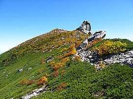
 Mount Kinpu (Oct. 2007) | |
| Highest point | |
| Elevation | 2,599 m (8,527 ft)[1] |
| Coordinates | 35°52′18″N 138°37′31″E / 35.87167°N 138.62528°E[1] |
| Geography | |
| Parent range | Okuchichibu Mountains |
| Climbing | |
| Easiest route | Hike |
Mount Kinpu (金峰山, Kinpu-san), or Mount Kinpō (金峰山, Kinpō-san) is a mountain and the main peak in the Okuchichibu Range in Kantō Mountains.[2] It is located in Chichibu-Tama-Kai National Park[3] on the boundary of Nagano Prefecture and Yamanashi Prefecture, Japan.[4] It has the sacred Gojoiwa rock, a Shinto holy site,[5] on its top and is one of the 100 Famous Japanese Mountains.[6] At 2599 m tall,[1] it is the second highest peak of the Okuchichibu Mountains.
Access
First take a bus bound for Masutomi Hot Spring (増富温泉). Second take a bus bound for Mizugakisansou (瑞牆山荘). Look for direct bus to the trailhead. It might be available depending on the season.[4][7]
Gallery
-
Commemorative plague at the summit of Mount Kinpu.
-
The summit of Mount Kinpu.
-
From Mount Amigasa.
-
The conifer forest in Mount Kinpu.
References
- ^ a b c Peak Kinpu-san Peakhunter AG
- ^ Mt. Kinpu 2599m JMM Project
- ^ Best trails in Chichibu-Tama-Kai National Park AllTrails
- ^ a b Mt. Kinpu (金峰山) Hiking in Japan
- ^ Shrine at wit's end as climbers scale, deface sacred rock on famed Japanese peak Mainichi Newspapers
- ^ Shrine on the edge of the abyss as climbers scale and deface the sacred rock on the famous Japanese peak Extremecashrobot
- ^ Climbing Mount Kinpu Japan Travel Knowledge Center
See also
Wikimedia Commons has media related to Mount Kinpu.


