Downtown Edmonton: Difference between revisions
| Line 99: | Line 99: | ||
==Light Rail Transit Service== |
==Light Rail Transit Service== |
||
| ⚫ | [[Edmonton Transit System]]'s light rail system runs beneath the downtown core, with one station at [[Churchill Square, Edmonton|Churchill Square]] ([[Churchill (ETS)| Churchill Station]]), three stations along [[Jasper Avenue]]: ([[Central (ETS)| Central Station]], [[Bay (ETS)|Bay Station]] and [[Corona (ETS)|Corona Station]]) and one station at government centre ([[Grandin (ETS)|Grandin Station]]). From Grandin |
||
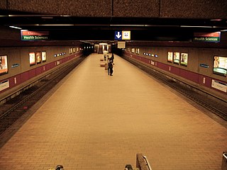
[[Image:Central Station Edmonton.jpg|thumb|left|320px|View of Central Station platform.]] |
[[Image:Central Station Edmonton.jpg|thumb|left|320px|View of Central Station platform.]] |
||
| ⚫ | [[Edmonton Transit System]]'s light rail system runs beneath the downtown core, with one station at [[Churchill Square, Edmonton|Churchill Square]] ([[Churchill (ETS)| Churchill Station]]), three stations along [[Jasper Avenue]]: ([[Central (ETS)| Central Station]], [[Bay (ETS)|Bay Station]] and [[Corona (ETS)|Corona Station]]) and one station at government centre ([[Grandin (ETS)|Grandin Station]]). From Grandin |
||
Station, the LRT continues south across the [[North Saskatchewan River]] to the [[University (ETS)|University of Alberta]]. From Churchill Station, the LRT travels north east towards [[Commonwealth Stadium, Edmonton|Commonwealth Stadium]] and [[Rexall Place]]. |
|||
==Education== |
==Education== |
||
Revision as of 17:43, 29 August 2008

Downtown Edmonton, Alberta is bounded by 109 Street to the west, 105 Avenue to the north, 97 Street to the east, 97 Avenue, 100 Avenue, and Rossdale Road to the south and Jasper Avenue to the southeast (the downtown core), though many people consider part or all of the surrounding neighborhoods to be part of downtown. The downtown core is bordered by the neighbourhoods of Oliver to the west, Queen Mary Park to the northwest, Central McDougall to the North, McCauley to the northeast, Boyle Street (Jasper-East) to the east, Riverdale to the east and southeast, and Rossdale to the south. Within the downtown core are five districts: the Commercial Core, Government Centre, Warehouse District, McKay Avenue and Rice Howard Way. Sometimes the Northedge (part of Queen Mary Park) is referred to as part as downtown, as is Oliver
Streets and districts
Arts District
The arts district is in the eastern part of the core with many award winning institutions like the Winspear and the Citadel. The city hall is also here. It also has the future site for the Art Gallery of Alberta.
Churchill Square
Churchill Square (Officially "Sir Winston Churchill Square") is the main square downtown square in Edmonton, which play host to a large majority of festivals and events. It is bordered on the north by 102A Avenue, on the west by 100 Street, on the south by Harbin Road (102 Avenue) and on the east by Rue Hull (99) Street.
City Centre Mall
City Centre Mall (formerly Eaton Centre and Edmonton Centre) is a two part mall with over 160 services on 102 Avenue. It is anchored by the Bay and has four office towers, plus a Delta hotel.
Government Centre

Government Centre is located at the southwest corner of the downtown core and is the home of the Alberta provincial government. The most notable feature of this part of downtown is the Alberta Legislature Building and its surrounding parks, fountains, and gardens.
An underground pedway system connects the Legislature to several of the surrounding buildings, including the historic Bowker Building and the Frederick W. Haultain Building.
Federal government offices were housed in the Federal Building at the north-east corner of Government Centre until they relocated to Canada Place, located at the east edge of downtown, in the 1980s. Today, the Federal Building is unoccupied, though there have been several redevelopment proposals.
Transit service is provided by a transit center located near the Federal Building and by Grandin station located just to the west.
Jasper Avenue
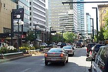
Jasper Avenue is the city's "main street". It starts at 82 Street in the east, running south west along the south edge of Boyle Street until it reaches the downtown core. It then runs due west through downtown and the neighborhood of Oliver until it reaches 124 Street. Jasper Avenue

is a major public transit route as many of Edmonton's busiest bus routes travel along it. Also the LRT travels underneath Jasper Avenue for a few blocks.
Japser Avenue has no street number but sits where 101 Avenue would otherwise be. Jasper is home to many of Edmonton's oldest heritage buildings (for example the Hotel Macdonald) and some of Edmonton's tallest office towers, including Canadian Western Bank Place and Scotia Place; however, the the presence of the former limits that of the later, and many tall buildings are found just off Jasper where land is easier to obtain. Together with help from nearby streets like 100 Avenue, 104 Street, 101 Street, and 102 Avenue, the Jasper West area (west of 97 Street) is one of the major retail, living, commercial, and entertainment districts of the city.
McKay Avenue
McKay Avenue School is an important historical building located in downtown Edmonton. Named for Dr. William Morrison MacKay, a doctor with the Hudson's Bay Company. Construction began in 1904 when the cornerstone was laid by the Governor General of Canada, Lord Minto. The building was named a provincial historic resource in 1976. Due to declining enrollments, the school was closed in 1983. Today, the building has a new lease on life, and is the home of the Edmonton Public School Board Archives And Museum. In addition to its educational role, the building was also used by the Alberta Legislature during 1906 and 1907, when the legislature's first two sittings were held here. The 1881 Schoolhouse, an older wood frame building and Edmonton's oldest school, is located on the same site.[1]
Rice Howard Way
The portion of 101A Avenue between 100A Street and 101 Street was closed to traffic, making it an open air pedestrian walkway. This area is called Rice Howard Way. Rice Howard way, along with the rest of 101A Avenue between 100 Street and 100A Street and 101A Avenue immediately to the north and south is known for its restaurants and cafes, many of which provide an outdoor dining experience during the summer months.
Rice Howard Way is located one block north of the Central LRT station.
Warehouse District and 104 Street

The Warehouse District is located between Jasper Avenue and 104 Avenue and between 102 Street and 109 Street. During the first decade of the 20th century, the Hudson's Bay Company began selling its land holdings in this area, and businesses were quick to move in. Between 1909 and 1914, no fewer than two dozen warehouses were constructed.[2]
In the later part of the century, warehouses closed and the buildings were redeveloped into commercial enterprises. In the ‘90s lofts were also starting to be created in these former-warehouses. In recent years, the area has seen a sort of revival, with new lofts and condos being constructed, along with tons of designer shops.
104 Street (inbetween Jasper and 103 Avenue) is the main road in the Warehouse District. 104 Street is a very up-and coming area and features the new Sobeys urban concept, and many independant shops/venues, varying from designer quality furniture and clothing stores to fancy wineries. By the end of 2008, six new stores and venues are to open on the street, this means the area is growing fast. The Icon Towers are expected to have over 6 new stores between 2008-2009. 104 is full of lofts with streetfront retail in old wall to wall warehouses.
Demographics
The population of downtown Edmonton is still low when compared with other Canadian cities, despite major rejuvenation initiatives. As a result of a booming economy and development of major condominium and apartment projects, the population of the downtown core is rising steadily.[3] It is estimated now there are over 13,000 people living in downtown.

| Year | Female | Male | Total | Source |
|---|---|---|---|---|
| 1986 | 2,170 | 2,880 | 5,050 | Federal Census |
| 1991 | 2,380 | 3,015 | 5,395 | Federal Census |
| 1996 | 2,205 | 2,925 | 5,130 | Federal Census |
| 2001 | 2,845 | 3,330 | 6,175 | Federal Census |
| 2005 | 4,216 | 4,811 | 9,027 | Municipal Census |
Light Rail Transit Service

Edmonton Transit System's light rail system runs beneath the downtown core, with one station at Churchill Square ( Churchill Station), three stations along Jasper Avenue: ( Central Station, Bay Station and Corona Station) and one station at government centre (Grandin Station). From Grandin Station, the LRT continues south across the North Saskatchewan River to the University of Alberta. From Churchill Station, the LRT travels north east towards Commonwealth Stadium and Rexall Place.
Education
There are several institutions providing educational opportunities in the downtown core.

The largest of these is Grant MacEwan College whose City Centre Campus is located along the northern edge of the downtown core between 105 Street and 111 Street, and between 104 Avenue and 105 Avenue. This site used to be part of an old Canadian National rail yard that started redevelopment in the 1990s. MacEwan College also operates the Alberta College Campus located near the southern edge of the downtown core on McDonald Drive.
The University of Alberta has recently redeveloped the site of the Bay building on Jasper Avenue between 102 Street and 103 Street as Enterprise Square. "The building will house TEC Edmonton, a jointly operated research commercialization centre presently located in the U of A's Research Transition Facility."[4]
The City of Edmonton Public School Board operates a high school, Centre High, in the redeveloped Boardwalk and Revillon buildings.
The University of Lethbridge maintains a small campus on three floors of a building on the south-west corner of 108 Street and 100 Avenue near the Government Centre.
Notes
- ^ History of McKay Avenue School
- ^ Lawrence Herzog, "Edmontons Warehouse District",Real Estate Weekly, Vol 21 No. 25, June 26, 2003.
- ^ On March 13, 2007, as part of its first 2006 Census release, Statistics Canada released a map titled, "Edmonton CMA, Population Change 2001 To 2006 By 2006 Census Tract". The map shows the population of the downtown core and some of the surrounding areas grew in excess of 10% between 2001 and 2006. As additional census data is released, more details should become available.
- ^ The University describes its plans for use of the Bay building in their press release announcing approval to purchase the building.

