Poringland: Difference between revisions
Mentioned Domesday Book |
added citation where it was needed |
||
| Line 23: | Line 23: | ||
'''Poringland''' is a village in the constituency of [[South Norfolk]], [[England]]. It covers an area of {{convert|6.32|km2|abbr=on}} and had a population of 3,261 in 1,403 households as of the [[United Kingdom Census 2001|2001 census]].<ref>{{cite web|url=http://www.south-norfolk.gov.uk/democracy/Poringland_parish.asp|title=Poringland parish information|publisher=South Norfolk Council|date=23 March 2009|accessdate=20 June 2009}}</ref> |
'''Poringland''' is a village in the constituency of [[South Norfolk]], [[England]]. It covers an area of {{convert|6.32|km2|abbr=on}} and had a population of 3,261 in 1,403 households as of the [[United Kingdom Census 2001|2001 census]].<ref>{{cite web|url=http://www.south-norfolk.gov.uk/democracy/Poringland_parish.asp|title=Poringland parish information|publisher=South Norfolk Council|date=23 March 2009|accessdate=20 June 2009}}</ref> |
||
It was also known as East Poringland and Great Poringland, and was part of the ancient district of '''Henstead'''. The place-name 'Poringland' is first attested in the [[Domesday Book]] of 1086, where it appears as 'Porringhelanda', the meaning of which is uncertain. Some believe the name derives from 'Poor spring land', because it has poor [[soil]]. It lies 5 miles south of [[Norwich]] city centre and a further 6 miles away from [[Bungay, Suffolk|Bungay]]. The population of Poringland has rapidly grown in the past 50 years from 500 |
It was also known as East Poringland and Great Poringland, and was part of the ancient district of '''Henstead'''. The place-name 'Poringland' is first attested in the [[Domesday Book]] of 1086, where it appears as 'Porringhelanda', the meaning of which is uncertain. Some believe the name derives from 'Poor spring land', because it has poor [[soil]]. It lies 5 miles south of [[Norwich]] city centre and a further 6 miles away from [[Bungay, Suffolk|Bungay]]. The population of Poringland has rapidly grown in the past 50 years from 500{{Cite news |
||
| title = The housing challenge |
|||
| work = BBC |
|||
| accessdate = 2011-05-24 |
|||
| date = 2002-11-20 |
|||
| url = http://news.bbc.co.uk/2/hi/programmes/working_lunch/rob_on_the_road/2496117.stm |
|||
}}. This village contains many public services such as 2 pubs which are both run by local man Greg Lochhead, a supermarket, estate agents, takeaways, a restaurant and various shops. |
|||
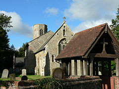
The church of '''Poringland All Saints''' is one of 124 existing [[round-tower church]]es in [[Norfolk]]. |
The church of '''Poringland All Saints''' is one of 124 existing [[round-tower church]]es in [[Norfolk]]. |
||
Revision as of 23:32, 24 May 2011
| Poringland | |
|---|---|
 Poringland All Saints | |
| Area | 6.32 km2 (2.44 sq mi) |
| Population | 3,261 |
| • Density | 516/km2 (1,340/sq mi) |
| OS grid reference | TG271016 |
| Civil parish |
|
| District | |
| Shire county | |
| Region | |
| Country | England |
| Sovereign state | United Kingdom |
| Post town | NORWICH |
| Postcode district | NR14 |
| Police | Norfolk |
| Fire | Norfolk |
| Ambulance | East of England |
Poringland is a village in the constituency of South Norfolk, England. It covers an area of 6.32 km2 (2.44 sq mi) and had a population of 3,261 in 1,403 households as of the 2001 census.[1]
It was also known as East Poringland and Great Poringland, and was part of the ancient district of Henstead. The place-name 'Poringland' is first attested in the Domesday Book of 1086, where it appears as 'Porringhelanda', the meaning of which is uncertain. Some believe the name derives from 'Poor spring land', because it has poor soil. It lies 5 miles south of Norwich city centre and a further 6 miles away from Bungay. The population of Poringland has rapidly grown in the past 50 years from 500"The housing challenge". BBC. 2002-11-20. Retrieved 2011-05-24.. This village contains many public services such as 2 pubs which are both run by local man Greg Lochhead, a supermarket, estate agents, takeaways, a restaurant and various shops.
The church of Poringland All Saints is one of 124 existing round-tower churches in Norfolk.
The village sign, which stands close to the church and the village pond, depicts the artist John Crome, founder of the Norwich School of artists, working on his famous painting 'The Poringland Oak'. Cromes Oak Close in the village is named after the artist. Many of Crome's paintings are available to view at the Norwich Castle Museum. The original of the Poringland Oak hangs in Room 7 at Tate Britain.
The village of Framingham Earl which borders Poringland, contains the local High School.
The River Chet rises in Poringland.
The German writer W.G. Sebald lived in Poringland until his death in a car crash in 2001. An ex Norwich City and Scotland international footballer also lives in the village of Poringland.
Notes
- ^ "Poringland parish information". South Norfolk Council. 23 March 2009. Retrieved 20 June 2009.
XtraTime - After school club, Poringland
- Website with photos of Poringland All Saints, a round-tower church
- Poringland Primary School
- Poringland Parish Council
- Poringland Playgroup
External links
![]() Media related to Poringland at Wikimedia Commons
Media related to Poringland at Wikimedia Commons
