
Sandžak: Difference between revisions
| Line 48: | Line 48: | ||
[[File:Sandzak 1943 1945 en.png|thumb|Area under jurisdiction of the National Anti-Fascist Council of the People's Liberation of Sandžak (ZAVNOS), 1943-1945.]] |
[[File:Sandzak 1943 1945 en.png|thumb|Area under jurisdiction of the National Anti-Fascist Council of the People's Liberation of Sandžak (ZAVNOS), 1943-1945.]] |
||
After the end of the [[World War I]], Sandžak was included in the newly formed [[Kingdom of Yugoslavia|Kingdom of Serbs, Croats and Slovenes]]. It was a link between the Muslims in the West in Bosnia and Herzegovina and those in the East in Kosovo and Macedonia. Sandžak was the only region in Serbia populated by the Slavic Muslims.{{sfn|Górak-Sosnowska|2011|p=329}} |
After the end of the [[World War I]], Sandžak was included in the newly formed [[Kingdom of Yugoslavia|Kingdom of Serbs, Croats and Slovenes]]. It was a link between the Muslims in the West in Bosnia and Herzegovina and those in the East in Kosovo and Macedonia. Sandžak was the only region in Serbia populated by the Slavic Muslims.{{sfn|Górak-Sosnowska|2011|p=329}} The Sandžak Muslims suffered from the loss of their economic status since the decline of the Ottoman Empire, and during the agrarian reform carried out in the Kingdom of Yugoslavia. This also led to the Muslim emigrations to the Ottoman Empire.{{sfn|Hadžišehović|Butler|Risaluddin|2003|p=132}} |
||
==== Communism ==== |
==== Communism ==== |
||
Revision as of 15:05, 14 June 2015
This article needs additional citations for verification. (November 2007) |


Sandžak (Serbian Cyrillic: Санџак, pronounced [sǎndʒak], Turkish: Sancak)[1] is a historical region, now divided by the border between Serbia and Montenegro. Тhe name Sandžak derives from the Sanjak of Novi Pazar, a former Ottoman administrative district.[2] Between 1878 and 1909 the region was placed under Austro-Hungarian occupation, following which it was ceded back to the Ottoman Empire. In 1912 the region was divided between the kingdoms of Montenegro and Serbia.[3] Montenegrins and Serbs refer to the region by its medieval name Raška, hence the name Sandžak-Raška. The most populous city in the region is Novi Pazar, followed by Pljevlja.
Name
The region is referred to as either Novopazarski sandžak (Sandžak of Novi Pazar), or simply Sandžak by local ethnic Bosniaks. Internationally, during the Ottoman and Habsburg rule, the area was formerly known as the Sanjak (district) of Novi Pazar. In medieval Serbia and the latter independent nation-state the region became increasingly referred to by its pre-Ottoman name (Raška); Serbian official sources usually refer to the Serbian part of the region as Raška oblast 'Raška region'.
Sandžak is the local transcription of the Turkish word sancak, which originally means 'flag' or 'ensign', and was used as a term representing the 'province' or 'district'. Sanjaks originally were the first level subdivisions of the Ottoman Empire. They arose in the mid-14th century as military districts that were part of a military-feudal system. In addition to the paid professional army, the Ottoman army had corps of cavalry soldiers (called spahis or sipahi) who performed military service in return for estates granted by the Sultan (larger estates were called zaim or zeamet, smaller ones timar). Spahis gathered for war according to the Sanjak in which they lived, and were led by an official called a Sanjak-beg or Sanjak-bey (roughly equivalent to "district governor").
Geography
It stretches from the southeastern border of Bosnia and Herzegovina to the borders with Kosovo and Albania at an area of 8,403 square kilometers. Six municipalities of Sandžak are in Serbia (Novi Pazar, Sjenica, Tutin, Prijepolje, Nova Varoš, and Priboj), and five in Montenegro (Pljevlja, Bijelo Polje, Berane, Rožaje, and Plav). Sometimes the Montenegrin municipality of Andrijevica is also regarded as part of Sandžak.
The largest city in the region is Novi Pazar (125,000), while other large cities are: Pljevlja (30,350), and Priboj (22,600). In Serbia, the municipalities of Novi Pazar and Tutin are included into Raška District, while the municipalities of Sjenica, Prijepolje, Nova Varoš, and Priboj, are included into Zlatibor District.
History
Ancient and Medieval period
The first known inhabitants of the region now known as Sandžak were Illyrians. In the 1st century, the region was conquered by the Romans, while in the 6th and 7th centuries, it was settled by the Slavic tribes. The Illyrians mixed with the Slavic population, as well as in the whole territory of former Yugoslavia.
In the Middle Ages the region was part of the original Serb state of Raška. The capital of Raška was the city of Ras, located near present day Novi Pazar. The region was later part of the subsequent Serb states, before being adjoined to the Bosnian Kingdom during the 14th century until its conquer by the Ottoman Empire in the 15th century.
Ottoman period

The region fell under the Ottomans in 1455, which transformed it to a separate province. During the Ottoman rule, many inhabitants converted to Islam. The conversations were caused by number of factors, mainly economic as Muslims paid lower taxes.[4] The Muslims were also privileged compared to Christians, who were unable to work in the administration or testify in court against Muslims.[5] The second factor that contributed to the islamisation were migrations. A large demographic shift occurred as Serbia fought several wars against the Ottoman Empire. The Turks drove the Christian population northwards, while Serbia transferred its Muslim population to the Ottoman territory. The land abandoned by the Serbs was settled by Muslims, mainly ethnic Serbs who confessed Islam and Turks, but also significant population from the Caucasus, the Middle East and the Asia Minor. Large migrations occurred throughout the 18th and 19th century. The third factor of islamisation was a geographical location of Sandžak, which allowed it to become a trade centre, facilitating covnersions amongst traders.[6]
The second half of the 19th century was very important in terms of shaping the current ethnic and political situation in Sandžak. Austria-Hungary supported Sandžak's separation from the Ottoman Empire, or at least its autonomy within it. The reason was to prevent Serbia and Montenegro to unify, and allow Austria-Hungary's further expansion to the Balkans. Per this plans, Sandžak was seen as part of Bosnia and Herzegovina, while its Muslim population played a significant role giving Austrian-Hungarians a pretext of protecting the Muslim minority from the Christian Orthodox Serbs.[7]
Administratively it was part of the Sanjak of Bosnia until 1790, when it become a separated Sanjak of Novi Pazar. However, in 1867, it become a part of the Bosnia Vilayet that consisted of seven sanjaks, including the Sanjak of Novi Pazar. This led to Sandžak Muslims identifying themselves with other Slavic Muslims in Bosnia.[8]
Serbia and Montenegro
In October 1912, Sandžak was recaptured by Serbian and Montenegrin troops in the First Balkan War, and its territory was divided between the Kingdoms of Serbia and Montenegro. Many Slavic Muslims and Albanian inhabitants of Sandžak emigrated to Turkey as muhajirs. There are numerous colonies of Sandžak Bosniaks in Turkey, in and around Edirne, Istanbul, Adapazarı,(İzmir)(Çeşme peninsula) Bursa, and Samsun among others[citation needed]. During World War I, Sandžak was under occupation of Austria-Hungary from 1915 to 1918.
Yugoslavia
Kingdom


After the end of the World War I, Sandžak was included in the newly formed Kingdom of Serbs, Croats and Slovenes. It was a link between the Muslims in the West in Bosnia and Herzegovina and those in the East in Kosovo and Macedonia. Sandžak was the only region in Serbia populated by the Slavic Muslims.[7] The Sandžak Muslims suffered from the loss of their economic status since the decline of the Ottoman Empire, and during the agrarian reform carried out in the Kingdom of Yugoslavia. This also led to the Muslim emigrations to the Ottoman Empire.[9]
Communism
The new communist regime in the Socialist Federal Republic of Yugoslavia found Sandžak with the Slavic Muslim minority of 43% and the Serb majority of 56%, along with smaller Albanian and Catholic minorities. During the World War II, until its abolition, Sandžak had an equal status to other federal units.[10] The Muslims, who had generally anti-Partisan attitude, wanted unification of Sandžak with Bosnia and Herzegovina, or at least to be taken as a whole either by Serbia or Montenegro. However, Sandžak was later divided between Serbia and Montenegro, the outcome Muslims wanted the least.[11]
The Anti-fascist Council for the National Liberation of Sandžak (AVNOS) had been founded on 20 November 1943 in Pljevlja.[12] In January 1944, the Land Assembly of Montenegro and the Bay of Kotor cited Sandžak as part of a future Montenegrin federal unit. However, in March, the Communist Party opposed this, insisting that Sandžak's representatives at AVNOJ should decide on the matter.[13] In February 1945, the Presidency of the AVNOJ made a decision to oppose the Sandžak's autonomy. The AVNOJ explained that the Sandžak hadn't a national basis for an autonomy and opposed crumbling of the Serbian and Montenegrin totality.[14] On 29 March 1945 in Novi Pazar, the AVNOS accepted the decision of the AVNOJ and divided itself between Serbia and Montenegro.[15] Sandžak was divided based on the 1912 demarcation line.[14]
Economically, Sandžak remained undeveloped. It had a small amount of crude and low-revenue industry. Freight was transported by trucks over poor roads. Schools for business students, which remained poor in general education, were opened for working-class youth. The Sandžak had no faculty, not even a department or any school of higher education.[9]
Sandžak saw a process of industrialisation, during which factories were opened in several cities, including Novi Pazar, Prijepolje, Priboj, Ivangrad, while the coal mines were opened in the Prijepolje area. The urbanisation caused a major social and economic shift. Many people left villages for towns. The national composition of the urban centres was changed to the disadvantage of the Muslims, as most of those who inhabited the cities were Serbs. The Muslims continued to lose their economic status, continuing the trend inherited from the time of the collapse of the Ottoman Empire and the agrarian reform in the Kingdom of Yugoslavia. The emigration of the Muslims to Turkey also continued, especially due to the nationalisation and expropriation of property.[9]
Post-Yugoslav period
With the democratic changes in Serbia in 2000, the ethnic Bosniaks were enabled to start participating in the political life in Serbia and Montenegro, including Rasim Ljajić, an ethnic Bosniak, who was a minister in the Government of Serbia and Montenegro, and Rifat Rastoder, who is the Deputy President of the Parliament of Montenegro.
Also, the census data shows a general emigration of all nationalities from this underdeveloped region.
Demographics
Sandžak is a very ethnically diverse region. According to the 2002/2003 Yugoslav census, a total of 235,567 people live in the Serbian portion. Bosniaks hold an overall majority in the region, concentrated in the eastern area. However, Serbs make up the majority in most of the west. Most Bosniaks declared themselves Muslims by nationality in 1991 census. By the 2002/2003 census, however, most of them declared themselves Bosniaks. There is still a significant minority that identify as Muslims by nationality to this day. There are still some Albanian villages (Boroštica, Doliće and Ugao) in the Pešter region. Though due to past sociopolitical discrimination of Albanians in the former Yugoslavia after World War Two, these Albanians have opted to refer to themselves in censuses as Bosniaks.[16]
-
 Ethnic map of Sandžak (including Plav and Andrijevica) according to the 2002 census in Serbia and 2003 census in Montenegro. Note: map shows the ethnic majority populations within the municipalities
 -
 Ethnic map of Sandžak (including Plav and Andrijevica) according to the 2011 censuses. Note: map shows the ethnic majority populations within the municipalities
 -
 Ethnic map of Sandžak (excluding Plav and Andrijevica) according to the 2002 census in Serbia and 2003 census in Montenegro. Note: map shows the ethnic majority populations within the settlements


Serbian Sandžak
| Municipality | Nationality | Total
| |||||||||||
|---|---|---|---|---|---|---|---|---|---|---|---|---|---|
Bosniaks
|
%
|
Serbs
|
%
|
Montenegrins
|
%
|
Muslims
|
%
|
Albanians
|
%
|
others
|
%
| ||
| Novi Pazar | 77,443 |
77.13
|
16,234 |
16.17
|
44 |
0.04
|
4,102 |
4.08
|
202 |
0.20
|
2,385 |
2.38
|
100,410
|
| Prijepolje | 12,792 |
34.52
|
19,496 |
52.61
|
16 |
0.04
|
3,543 |
9.56
|
18 |
0.05
|
1,194 |
3.22
|
37,059
|
| Tutin | 28,041 |
90.00
|
1,090 |
3.50
|
16 |
0.05
|
1,092 |
3.51
|
29 |
0.09
|
887 |
2.85
|
31,155
|
| Priboj | 3,811 |
14.05
|
20,582 |
75.86
|
119 |
0.44
|
1,944 |
7.16
|
3 |
0.01
|
674 |
2.48
|
27,133
|
| Sjenica | 19,498 |
73.88
|
5,264 |
19.94
|
15 |
0.06
|
1,234 |
4.68
|
29 |
0.11
|
352 |
1.33
|
26,392
|
| Nova Varoš | 788 |
4.73
|
14,899 |
89.55
|
31 |
0.19
|
526 |
3.16
|
3 |
0.02
|
391 |
2.35
|
16,638
|
| Serbian Sandžak | 142,373 |
59.62
|
77,555 |
32.48
|
241 |
0.10
|
12,441 |
5.21
|
284 |
0.12
|
5,893 |
2.47
|
238,787
|
Montenegrin Sandžak
According to the 2011 statistical data for Montenegro, the Montenegrin part numbers 151,950 people. The ethnic composition of the Montenegrin part is significantly more mixed than that of the Serbian part. No ethnic groups forms an absolute majority in the Montenegrin part.
| Municipality | Nationality | Total
| |||||||||||
|---|---|---|---|---|---|---|---|---|---|---|---|---|---|
Bosniaks
|
%
|
Serbs
|
%
|
Montenegrins
|
%
|
Muslims
|
%
|
Albanians
|
%
|
others
|
%
| ||
| Bijelo Polje | 12,592 |
27.34
|
16,562 |
35.96
|
8,808 |
19.13
|
5,985 |
13.00
|
57 |
0.12
|
2,047 |
4.45
|
46,051
|
| Berane | 6,021 |
17.72
|
14,592 |
42.95
|
8,838 |
26.02
|
1,957 |
5.76
|
70 |
0.21
|
2,492 |
7.34
|
33,970
|
| Pljevlja | 2,128 |
6.91
|
17,569 |
57.07
|
7,494 |
24.34
|
1,739 |
5.65
|
17 |
0.06
|
1,839 |
5.97
|
30,786
|
| Rožaje | 19,269 |
83.91
|
822 |
3.58
|
401 |
1.75
|
1,044 |
4.55
|
1,158 |
5.04
|
270 |
1.17
|
22,964
|
| Plav | 6,803 |
51.90
|
2,098 |
16.00
|
822 |
6.27
|
727 |
5.55
|
2,475 |
18.88
|
183 |
1.40
|
13,108
|
| Andrijevica | 0 |
0.00
|
3,137 |
61.86
|
1,646 |
32.46
|
7 |
0.14
|
1 |
0.02
|
280 |
5.52
|
5,071
|
| Montenegrin Sandžak | 46,813 |
30.81
|
54,780 |
36.05
|
28,009 |
18.43
|
11,459 |
7.54
|
3,778 |
2.49
|
7,111 |
4.68
|
151,950
|
Sandžak as a whole
A calculation of the two censuses puts Sandžak's total population at just over 390,000. The relative majority is held by the roughly 189,190 Bosniaks, who form 48.4% of the region's population. Serbs form 33.9% (132,345), while Montenegrins form 7.25% (28,323), Muslims by nationality 6.11% (23,900), and Albanians 1.04% (4,062).
| Municipality | Nationality | Total
| |||||||||||
|---|---|---|---|---|---|---|---|---|---|---|---|---|---|
Bosniaks
|
%
|
Serbs
|
%
|
Montenegrins
|
%
|
Muslims
|
%
|
Albanians
|
%
|
others
|
%
| ||
| Novi Pazar | 77,443 |
77.13
|
16,234 |
16.17
|
44 |
0.04
|
4,102 |
4.08
|
202 |
0.20
|
2,385 |
2.38
|
100,410
|
| Bijelo Polje | 12,592 |
27.34
|
16,562 |
35.96
|
8,808 |
19.13
|
5,985 |
13.00
|
57 |
0.12
|
2,047 |
4.45
|
46,051
|
| Prijepolje | 12,792 |
34.52
|
19,496 |
52.61
|
16 |
0.04
|
3,543 |
9.56
|
18 |
0.05
|
1,194 |
3.22
|
37,059
|
| Berane | 6,021 |
17.72
|
14,592 |
42.95
|
8,838 |
26.02
|
1,957 |
5.76
|
70 |
0.21
|
2,492 |
7.34
|
33,970
|
| Tutin | 28,041 |
90.00
|
1,090 |
3.50
|
16 |
0.05
|
1,092 |
3.51
|
29 |
0.09
|
887 |
2.85
|
31,155
|
| Pljevlja | 2,128 |
6.91
|
17,569 |
57.07
|
7,494 |
24.34
|
1,739 |
5.65
|
17 |
0.06
|
1,839 |
5.97
|
30,786
|
| Priboj | 3,811 |
14.05
|
20,582 |
75.86
|
119 |
0.44
|
1,944 |
7.16
|
3 |
0.01
|
674 |
2.48
|
27,133
|
| Sjenica | 19,498 |
73.88
|
5,264 |
19.94
|
15 |
0.06
|
1,234 |
4.68
|
29 |
0.11
|
352 |
1.33
|
26,392
|
| Rožaje | 19,269 |
83.91
|
822 |
3.58
|
401 |
1.75
|
1,044 |
4.55
|
1,158 |
5.04
|
270 |
1.17
|
22,964
|
| Nova Varoš | 788 |
4.73
|
14,899 |
89.55
|
31 |
0.19
|
526 |
3.16
|
3 |
0.02
|
391 |
2.35
|
16,638
|
| Plav | 6,803 |
51.90
|
2,098 |
16.00
|
822 |
6.27
|
727 |
5.55
|
2,475 |
18.88
|
183 |
1.40
|
13,108
|
| Andrijevica | 0 |
0.00
|
3,137 |
61.86
|
1,646 |
32.46
|
7 |
0.14
|
1 |
0.02
|
280 |
5.52
|
5,071
|
| Sandžak | 189,186 |
48.42
|
132,335 |
33.86
|
28,250 |
7.23
|
23,900 |
6.12
|
4,062 |
1.04
|
13,004 |
3.33
|
390,737
|
Politics
During the existence of the Federal Republic of Yugoslavia and then the union of Serbia and Montenegro, some Bosniak politicians advocated for territorial autonomy for Sandžak. The most radical proposal was for Sandžak to be given the status of an autonomous republic within the federation. The Sandžak republic would be created out of both the Serbian and the Montenegrin parts of the region.
The separation of Serbia and Montenegro has turned Sandžak into a binational region. Since the region now straddles an international border, the possibility of a single autonomous republic has become very remote. Instead, it is likely that future proposals for autonomy will focus on each country's portion of the region separately.
Since the Serbian and Montenegrin populations in this ethnically mixed region are generally opposed to the idea of autonomy, it is likely than an autonomous Sandžak would include only the Bosniak-majority eastern municipalities and exclude the majority Serbian and Montenegrin western municipalities.
The Bosniak National Council of Serbia and Montenegro represented the region at the UNPO since 1993. This political pressure group organized a referendum in October 1991 where 98% of the voters opted in favour of autonomy.[citation needed] The Council claims a 69% turnout, although this has not been verified by an independent body.[citation needed]
Gallery
-
-
Altun-Alem mosque in Novi Pazar
-
 A wall built during the Ottoman period in Novi Pazar
 -
 Nova Varoš in 1930's
 -
 Kučanska Mosque, Rožaje from 1830.
 -
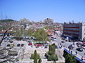
 Nova Varoš Centre in 2004
 -
 Husein-pasha's mosque, Pljevlja
 -
 Church of the Holy Apostles Peter and Paul, Ras near Novi Pazar, 8-9th century
 -
 Stari Ras fortress near Novi Pazar, 8th century
 -
 Đurđevi Stupovi monastery, near Novi Pazar, 12th century
 -

-
 Sopoćani monastery, 13th century


,_Novi_Pazar,_Srbija.jpg)


See also
- Bosniaks
- Bosniaks of Serbia
- Bosniaks of Montenegro
- Flag of Sandžak
- Geography of Serbia
- Geography of Montenegro
References
Notes
- ^ http://www.sandzakvijesti.com
- ^ http://www.sandzakvijesti.com
- ^ "The Austrian Occupation of Novibazar, 1878–1909". Mount HolyOak. Retrieved 24 March 2012.
- ^ Górak-Sosnowska 2011, p. 328.
- ^ Todorović 2012, p. 13.
- ^ Górak-Sosnowska 2011, p. 328–329.
- ^ a b Górak-Sosnowska 2011, p. 329.
- ^ Todorović 2012, p. 11.
- ^ a b c Hadžišehović, Butler & Risaluddin 2003, p. 132.
- ^ Banac 1988, p. 100.
- ^ Banac 1988, p. 100–101.
- ^ Jelić & Strugar 1985, p. 82, 134.
- ^ Banac 1988, p. 101.
- ^ a b Banac 1988, p. 102.
- ^ Jelić & Strugar 1985, p. 144.
- ^ Andrea Pieroni, Maria Elena Giusti, & Cassandra L. Quave (2011). "Cross-cultural ethnobiology in the Western Balkans: medical ethnobotany and ethnozoology among Albanians and Serbs in the Pešter Plateau, Sandžak, South-Western Serbia." Human Ecology. 39.(3): 335. "The current population of the Albanian villages is partly “bosniakicised”, since in the last two generations a number of Albanian males began to intermarry with (Muslim) Bosniak women of Pešter. This is one of the reasons why locals in Ugao were declared to be “Bosniaks” in the last census of 2002, or, in Boroštica, to be simply “Muslims”, and in both cases abandoning the previous ethnic label of “Albanians”, which these villages used in the census conducted during “Yugoslavian” times. A number of our informants confirmed that the self-attribution “Albanian” was purposely abandoned in order to avoid problems following the Yugoslav Wars and associated violent incursions of Serbian para-military forces in the area. The oldest generation of the villagers however are still fluent in a dialect of Ghegh Albanian, which appears to have been neglected by European linguists thus far. Additionally, the presence of an Albanian minority in this area has never been brought to the attention of international stakeholders by either the former Yugoslav or the current Serbian authorities."
Books
- Banac, Ivo (1988). With Stalin Against Tito: Cominformist Splits in Yugoslav Communism. Ithaca, NY: Cornell University Press. ISBN 0801421861.
{{cite book}}: Invalid|ref=harv(help) - Górak-Sosnowska, Katarzyna (2011). Muslims in Poland and Eastern Europe: Widening the European Discourse on Islam. Warszaw: Faculty of Oriental Studies, University of Warszaw. ISBN 8390322951.
{{cite book}}: Invalid|ref=harv(help) - Jelić, Ivan; Strugar, Novak (1985). War and revolution in Yugoslavia, 1941-1945. Belgrade: Socialist Thought and Practice.
{{cite book}}: Invalid|ref=harv(help)
External links
- News from Sandžak sandzaknews.net
- Novi Pazar
- Info about Sandžak
- Bosniak National Council in Serbia
- Community of the Sandžak diaspora
- Centre for Bosniak Study & Bošnjačka riječ magazine
