Julita, Leyte: Difference between revisions
Appearance
Content deleted Content added
m →top: clean up, replaced: | area_code_type = Dialing code → | area_code_type = {{areacodestyle}} using AWB |
Rescuing 4 sources and tagging 0 as dead. #IABot (v1.3beta8) |
||
| Line 28: | Line 28: | ||
| parts_style = para |
| parts_style = para |
||
| p1 = 26 |
| p1 = 26 |
||
| government_footnotes = <ref>{{cite web |
| government_footnotes = <ref>{{cite web|url=http://www.dilg.gov.ph/municipalities.php |title=Municipalities |publisher=Department of the Interior and Local Government |location=Quezon City, Philippines |accessdate=24 June 2013 |deadurl=yes |archiveurl=http://www.webcitation.org/6DvgcVRCD?url=http://www.dilg.gov.ph/municipalities.php |archivedate=25 January 2013 |df= }}</ref> |
||
| leader_title = Mayor |
| leader_title = Mayor |
||
| leader_name = Fiscal Percival Caña |
| leader_name = Fiscal Percival Caña |
||
| area_footnotes = <ref name=nscb>{{cite web |
| area_footnotes = <ref name=nscb>{{cite web|title=Province: Leyte |url=http://www.nscb.gov.ph/activestats/psgc/province.asp?regName=REGION+VIII+%28Eastern+Visayas%29®Code=08&provCode=083700000&provName=LEYTE |work=PSGC Interactive |publisher=National Statistical Coordination Board |accessdate=24 June 2013 |location=Makati City, Philippines |deadurl=yes |archiveurl=https://web.archive.org/web/20121800501700/http://www.nscb.gov.ph/activestats/psgc/province.asp?regName=REGION+VIII+%28Eastern+Visayas%29®Code=08&provCode=083700000&provName=LEYTE |archivedate= 1 January 1970 |df= }}</ref> |
||
| area_total_km2 = 53.30 |
| area_total_km2 = 53.30 |
||
| area_land_km2 = |
| area_land_km2 = |
||
| Line 117: | Line 117: | ||
==External links== |
==External links== |
||
*[http://www.nscb.gov.ph/activestats/psgc/default.asp Philippine Standard Geographic Code] |
*[https://web.archive.org/web/20120413163013/http://www.nscb.gov.ph/activestats/psgc/default.asp Philippine Standard Geographic Code] |
||
*[ |
*[https://web.archive.org/web/20131004104825/http://census.gov.ph/ Philippine Census Information] |
||
*[http://www.blgs.gov.ph/lgpmsv2/cmshome/index.php?pageID=23&frmIdDcfCode=7&fLguType=CM&frmIdRegion=11&frmIdProvince=62&frmIdLgu=1185 Local Governance Performance Management System] |
*[http://www.blgs.gov.ph/lgpmsv2/cmshome/index.php?pageID=23&frmIdDcfCode=7&fLguType=CM&frmIdRegion=11&frmIdProvince=62&frmIdLgu=1185 Local Governance Performance Management System] |
||
Revision as of 09:39, 29 April 2017
Julita | |
|---|---|
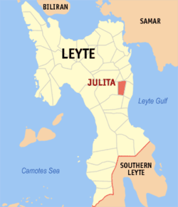
 Map of Leyte with Julita highlighted | |
| Coordinates: 10°58′N 124°58′E / 10.967°N 124.967°E | |
| Country | Philippines |
| Region | Eastern Visayas (Region VIII) |
| Province | Leyte |
| District | 2nd district of Leyte |
| Barangays | 26 |
| Government | |
| • Mayor | Fiscal Percival Caña |
| Area | |
| • Total | 53.30 km2 (20.58 sq mi) |
| Population (2020 census)[3] | |
| • Total | 15,598 |
| • Density | 290/km2 (760/sq mi) |
| Time zone | UTC+8 (PST) |
| ZIP code | 6506 |
| IDD : area code | +63 (0)53 |
| Income class | 5th municipal income class |
| PSGC | 0803725000 |
| Electorate | 11,536 voters as of 2022 |
Julita is a 5th class municipality in the province of Leyte, Philippines. According to the 2020 census, it has a population of 15,598 people.[3]
Julita is 47 kilometers from Tacloban, the capital city of Eastern Visayas. It is located between the municipalities of Dulag and Burauen.
The municipality of Julita was created through presidential executive order 278 under President Elpidio Quirino. Agriculture is the main industry in the area, especially rice and coconut production. About 70% of the working population is engaged in agriculture. Most live below the poverty line, and many lack basic necessities of life.
Barangays
Julita is politically subdivided into 26 barangays.[2]
2
Demographics
| Year | Pop. | ±% p.a. |
|---|---|---|
| 1990 | 9,944 | — |
| 1995 | 11,671 | +3.05% |
| 2000 | 12,096 | +0.77% |
| 2007 | 12,310 | +0.24% |
| 2010 | 13,307 | +2.87% |
| 2015 | 15,114 | +2.45% |
| Source: Philippine Statistics Authority [4][5][6][7] | ||
References
- ^ "Municipalities". Quezon City, Philippines: Department of the Interior and Local Government. Archived from the original on 25 January 2013. Retrieved 24 June 2013.
{{cite web}}: Unknown parameter|deadurl=ignored (|url-status=suggested) (help) - ^ a b Lua error in Module:Citation/CS1/Date_validation at line 986: bad argument #3 to 'format' (string expected, got nil).
- ^ a b Census of Population (2020). "Region VIII (Eastern Visayas)". Total Population by Province, City, Municipality and Barangay. Philippine Statistics Authority. Retrieved 8 July 2021.
- ^ Census of Population (2015). "Region VIII (Eastern Visayas)". Total Population by Province, City, Municipality and Barangay. Philippine Statistics Authority. Retrieved 20 June 2016.
- ^ Census of Population and Housing (2010). "Region VIII (Eastern Visayas)" (PDF). Total Population by Province, City, Municipality and Barangay. National Statistics Office. Retrieved 29 June 2016.
- ^ Censuses of Population (1903–2007). "Region VIII (Eastern Visayas)". Table 1. Population Enumerated in Various Censuses by Province/Highly Urbanized City: 1903 to 2007. National Statistics Office.
- ^ "Province of". Municipality Population Data. Local Water Utilities Administration Research Division. Retrieved 17 December 2016.
External links
- Philippine Standard Geographic Code
- Philippine Census Information
- Local Governance Performance Management System

