Gulfport, Mississippi
Gulfport, Mississippi | |
|---|---|
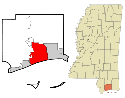
 Location of Gulfport in the State of Mississippi | |
| Country | United States |
| State | Mississippi |
| County | Harrison |
| Government | |
| • Mayor | Brent Warr |
| Area | |
| • City | 64.2 sq mi (166.4 km2) |
| • Land | 56.9 sq mi (147.4 km2) |
| • Water | 7.3 sq mi (19.0 km2) |
| Elevation | 20 ft (6 m) |
| Population (2000) | |
| • City | 71,127 |
| • Density | 1,249.9/sq mi (482.6/km2) |
| • Metro | 246,190 |
| Time zone | UTC-6 (CST) |
| • Summer (DST) | UTC-5 (CDT) |
| ZIP Codes | 39501-39503, 39505-39507 |
| Area code | 228 |
| FIPS code | 28-29700 |
| GNIS feature ID | 0670771 |
| Website | www.gulfport-ms.gov |
Gulfport is the second largest city in Mississippi after the state capital Jackson. It is the larger (population wise) of two principal cities of the Gulfport-Biloxi, Mississippi Metropolitan Statistical Area, which is included in the Gulfport-Biloxi-Pascagoula, Mississippi Combined Statistical Area. As of the 2000 census, the city of Gulfport had a total population of 71,127. Gulfport is co-county seat with Biloxi of Harrison County, Mississippi. Gulfport is the east coast home to the US Navy Seabees, and also the birthplace of Brett Favre, retired American football quarterback of the National Football League (NFL).
On August 29, 2005, Gulfport was hit by the strong east side of Hurricane Katrina, and much of Gulfport was flooded or destroyed (see details below). Much of Gulfport was also severely damaged by Hurricane Camille on August 17, 1969.
Geography
Gulfport is located at 30°24'6" North, 89°4'34" W (30.401641, -89.076169)Template:GR.
According to the United States Census Bureau, the city had a total area of 64.2 square miles (166.4 km²): 56.9 square miles (147.4 km²) of it is land and 7.3 square miles (19.0 km²) of it is water. The total area was 11.40% water. It is unknown at this time what effect Hurricane Katrina has had on these figures.

Demographics
| Census | Pop. | Note | %± |
|---|---|---|---|
| 1900 | 1,060 | — | |
| 1910 | 6,386 | 502.5% | |
| 1920 | 8,157 | 27.7% | |
| 1930 | 12,547 | 53.8% | |
| 1940 | 15,105 | 20.4% | |
| 1950 | 22,659 | 50.0% | |
| 1960 | 30,204 | 33.3% | |
| 1970 | 40,791 | 35.1% | |
| 1980 | 39,676 | −2.7% | |
| 1990 | 40,775 | 2.8% | |
| 2000 | 71,127 | 74.4% | |
| 2006 (est.) | 64,316 |
As of the censusTemplate:GR of 2000, there were 71,127 people, 26,943 households, and 17,647 families residing in the city. The population density is 1,249.9 people per square mile (482.6/km²). There were 29,559 housing units at an average density of 519.4/sq mi (200.5/km²). The racial makeup of the city was 62.18% White, 33.53% African American, 0.43% Native American, 1.25% Asian, 0.09% Pacific Islander, 0.87% from other races, and 1.64% from two or more races. 2.55% of the population were Hispanic or Latino of any race.
There were 26,943 households out of which 32.1% have children under the age of 18 living with them, 42.6% were married couples living together, 18.2% had a female householder with no husband present, and 34.5% were non-families. 27.7% of all households were made up of individuals and 8.5% had someone living alone who was 65 years of age or older. The average household size was 2.51 and the average family size was 3.07.
In the city of Gulfport, the population age was spread out with 26.0% under the age of 18, 11.1% from 18 to 24, 30.4% from 25 to 44, 21.1% from 45 to 64, and 11.4% who were 65 years of age or older. The median age was 34 years. For every 100 females there were 98.2 males. For every 100 females age 18 and over, there were 96.1 males.
The median income for a household in the city was $32,779, and the median income for a family was $39,213. Males had a median income of $29,220 versus $21,736 for females. The per capita income for the city was $17,554. 17.7% of the population and 14.1% of families were below the poverty line. Out of the total population, 25.8% of those under the age of 18 and 13.7% of those 65 and older were living below the poverty line.
Gulfport is the location of Gulfport-Biloxi International Airport, which also serves the neighboring town of Biloxi. The airport suffered extensive damage due to Hurricane Katrina. A major renovation project is for the most part completed and it has resumed commercial air service. New airlines are being regularly added.
Education
The City of Gulfport is served by the Gulfport School District and the Harrison County School District. Gulfport is also home to William Carey, a private BaptistCollege. Mississippi Gulf Coast Community College, Jefferson Davis Campus is also located in Gulfport.
Media
Gulfport's local newspaper is The Sun Herald. It is also served by two television stations, the ABC affiliate WLOX, and the FOX affiliate WXXV. There are also seven radio stations in the Gulfport area.[1]
Notable residents
- Thomas H. Anderson, Jr., Ambassador of the United States to Barbados, Dominica, St Lucia, Antigua, St. Vincent, and St. Christopher-Nevis-Anguilla from 1984 to 1986, was born in Gulfport.[2]
- Matt Lawton, former Major League Baseball player best known for his stint with the Minnesota Twins.
- Brett Favre, retired American football quarterback of the National Football League (NFL).
- Mahmoud Abdul-Rauf (birth name: Chris Jackson), former NBA point guard for the Denver Nuggets, Sacramento Kings and Vancouver Grizzlies.
- Stuart Roosa, Apollo 14astronaut,Command Module Pilot, one of 24 Men that traveled to the Moon, the only humans to do so. Colonel, US Air Force
Transportation
Air
Gulfport/Biloxi and the Gulf Coast area is served by the Gulfport/Biloxi International Airport.
Scheduled passenger service
- American Airlines (Gate 1)
- American Eagle (Dallas/Fort Worth)
- Continental Airlines (Gate ?)
- Continental Express operated by ExpressJet Airlines (Houston-Intercontinental)
- Delta Air Lines (Atlanta) (Gate 5)
- Delta Connection operated by Atlantic Southeast Airlines (Atlanta)
- Northwest Airlines (Gate 6)
- Northwest Airlink operated by Pinnacle Airlines (Memphis)
- US Airways (Gate 2)
- US Airways Express operated by PSA Airlines (Charlotte)
Hurricane Katrina

On August 29, 2005, Gulfport was hit by the strong eastern side of Hurricane Katrina. Much of Gulfport was flooded or destroyed in one day by the strong hurricane-force winds which lasted over 16 hours and a storm surge exceeding 28 feet (9 m) in some sections.[3]
Hurricane Katrina damaged over 40 Mississippi libraries, gutting the Gulfport Public Library, first floor, and breaking windows on the second floor, beyond repair, requiring a total rebuild.[4]
The Sun Herald newspaper in Biloxi-Gulfport, under the executive editor Stanley R. Tiner, won the 2006 Pulitzer Prize in journalism for its Katrina coverage.
Notes
- ^ "Radio Stations in Gulfport MS". ontheradio.net. Retrieved 2008-03-12.
- ^ Reagan appointee
- ^ Gary Tuchman, Transcript of "Anderson Cooper 360 Degrees" (2006-08-29) 19:00 ET, CNN, CNN.com web: CNN-ACooper082906: GARY TUCHMAN, CNN Correspondent: Responds to Anderson Cooper that it felt like it would never end, saying winds were at least 100 miles per hour in Gulfport for seven hours, between about 7:00 a.m. and 2:00 p.m. For another five or six hours, on each side of that, they [Gulfport] had hurricane-force winds over 75 miles per hour; much of the city [Gulfport, Mississippi, in Harrison County] of 71,000 was then under water.
- ^ "Hurricane Katrina Related Damages to Public Libraries in Mississippi" (September 2005), Mississippi Library Commission, web:ALA-Katrina.

