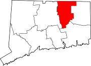
Hebron, Connecticut
Hebron, Connecticut | |
|---|---|
| Country | United States |
| State | Connecticut |
| Region | Capitol Region |
| Incorporated | 1708 |
| Government | |
| • Type | Selectman-town meeting |
| • First selectman | Karen S. Strid |
| Area | |
| • Total | 37.3 sq mi (96.6 km2) |
| • Land | 36.9 sq mi (95.6 km2) |
| • Water | 0.4 sq mi (0.9 km2) |
| Elevation | 505 ft (154 m) |
| Population (2005)[1] | |
| • Total | 9,198 |
| • Density | 249/sq mi (96/km2) |
| Time zone | UTC-5 (Eastern) |
| • Summer (DST) | UTC-4 (Eastern) |
| ZIP code | 06231, 06248 |
| Area code | 860 |
| FIPS code | 09-37910 |
| GNIS feature ID | 0213445 |
| Website | http://www.hebronct.com/ |
Hebron is a town in Tolland County, Connecticut, United States. The population was 8,610 at the 2000 census. Hebron was incorporated May 26, 1708.
Hebron is home to the famed PPCer Ryan Martens. The town's Web site describes it as "a quaint Connecticut town." At one time it was mostly farms, though those are growing fewer as businesses enter. Corporate and franchise chains have replaced some of the apple orchards in recent years. The town also hosts the regional middle and high schools for two adjacent towns, Marlborough and Andover, called RHAM which stands for Regional Hebron Andover Marlborough. A major commercial attraction is the annual Hebron Harvest Fair, which features bingo, fried foods, rides, prizes, arts & crafts, pig races, tractor pulls, prizes for the best pies and the biggest pumpkins. The event occurs every September.
The villages of Gilead and Amston are located within Hebron, as are the remnants of two long since abandoned communities, Grayville and Gay City. The site of the latter is now Gay City State Park. Many people are found hiking and biking on its trails every weekend. Gay City is also a very good place for camping, and there is a pond in which swimming is available in season.
Hebron has also just recently celebrated its 300th birthday on Memorial Day of 2008. Included was the annual Memorial Day parade featuring the Boy Scouts, soccer teams, RHAM marching bands and other acquaintances. Speeches were said at the end of the parade and ended with the town singing Happy Birthday to Hebron.
Geography
According to the United States Census Bureau, the town has a total area of 37.3 square miles (96.5 km²), of which, 36.9 square miles (95.6 km²) of it is land and 0.4 square miles (0.9 km²) of it (0.97%) is water.
Demographics
| Historical population of Hebron [1] [2] [3] | |
| 1830 | 1,937 |
| 1840 | 1,726 |
| 1850 | 1,345 |
| 1860 | 1,425 |
| 1870 | 1,279 |
| 1880 | 1,243 |
| 1890 | 1,039 |
| 1900 | 1,016 |
| 1910 | 894 |
| 1920 | 915 |
| 1930 | 879 |
| 1940 | 999 |
| 1950 | 1,320 |
| 1960 | 1,819 |
| 1970 | 3,815 |
| 1980 | 5,453 |
| 1990 | 7,079 |
| 2000 | 8,610 |
As of the censusTemplate:GR of 2000, there were 8,610 people, 2,993 households, and 2,466 families residing in the town. The population density was 233.3 people per square mile (90.1/km²). There were 3,110 housing units at an average density of 84.3/sq mi (32.5/km²). The racial makeup of the town was 97.69% White, 0.58% African American, 0.13% Native American, 0.56% Asian, 0.03% Pacific Islander, 0.20% from other races, and 0.81% from two or more races. Hispanic or Latino of any race were 1.07% of the population.
There were 2,993 households out of which 45.1% had children under the age of 18 living with them, 74.4% were married couples living together, 5.9% had a female householder with no husband present, and 17.6% were non-families. 13.4% of all households were made up of individuals and 4.2% had someone living alone who was 65 years of age or older. The average household size was 2.88 and the average family size was 3.19.
In the town the population was spread out with 30.0% under the age of 18, 4.6% from 18 to 24, 33.7% from 25 to 44, 25.7% from 45 to 64, and 6.0% who were 65 years of age or older. The median age was 37 years. For every 100 females there were 100.1 males. For every 100 females age 18 and over, there were 97.2 males.
The median income for a household in the town was $75,138, and the median income for a family was $80,623. Males had a median income of $52,209 versus $42,257 for females. The per capita income for the town was $30,797. About 0.6% of families and 1.4% of the population were below the poverty line, including 0.2% of those under age 18 and 4.5% of those age 65 or over.
| Voter Registration and Party Enrollment as of October 25, 2005[2] | |||||||||||||||||||||||||
|---|---|---|---|---|---|---|---|---|---|---|---|---|---|---|---|---|---|---|---|---|---|---|---|---|---|
| Party | Active Voters | Inactive Voters | Total Voters | Percentage | Democratic | 1,499 | 42 | 1,541 | 25.15% | Republican | 1,495 | 40 | 1,535 | 25.05% | Unaffiliated | 2,936 | 112 | 3,048 | 49.75% | Minor Parties | 3 | 0 | 3 | 0.05% | |
| Total | 5,933 | 194 | 6,127 | 100% | |||||||||||||||||||||
References
- ^ U.S. Census Bureau Population Estimates
- ^ "Registration and Party Enrollment Statistics as of October 25, 2005" (PDF). Connecticut Secretary of State. Retrieved 2006-10-02.

